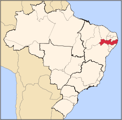
Lagoa do Carro
Lagoa do Carro is a city in Pernambuco, Brazil. It is located in Zona da mata Pernambucana region at 60 km of the state capital Recife.
Lagoa do Carro | |
|---|---|
City | |
 Lagoa do Carro Lagoa do Carro located in Brazil Map | |
| Coordinates: 07°50′42″S 35°19′12″W | |
| Country | |
| State | Pernambuco |
| Region | Zona da mata |
| Area | |
| • Total | 68.87 km2 (26.59 sq mi) |
| Elevation | 128 m (420 ft) |
Geography
- State - Pernambuco
- Region - Zona da mata Pernambucana
- Boundaries - Carpina (N and E); Lagoa do Itaenga (S); Limoeiro (W)
- Area - 68.87 km2
- Elevation - 128 m
- Hydrography - Capibaribe and Goiana Rivers
- Vegetation - Subcaducifólia forest
- Climate - Hot tropical and humid
- Distance to Recife - 60 km
Economy
The main economic activities in Lagoa do Carro are based in industry and agribusiness; especially cattle, goats, pigs and chickens.
Economic Indicators
| Population[1] | GDP x(1000 R$).[2] | GDP pc (R$) | PE |
|---|---|---|---|
| 15.230 | 48.376 | 3.364 | 0.08% |
Economy by Sector (2006)
| Primary sector | Secondary sector | Service sector |
|---|---|---|
| 18.63% | 8.26% | 73.11% |
Health Indicators
| HDI (2000)[3] | Hospitals (2007) | Hospitals beds (2007) | Children's Mortality every 1000 (2005) |
|---|---|---|---|
| 0.654 | 1 | 13 | 20.2 |
gollark: https://wiki.haskell.org/Web/Frameworks
gollark: Yesod is the big popular one.
gollark: > are there any good web frameworks for haskellServant, for APIs?
gollark: Great idea.
gollark: You introduce types to part of your codebase.
References
This article is issued from Wikipedia. The text is licensed under Creative Commons - Attribution - Sharealike. Additional terms may apply for the media files.
