Nazareth Bank
Nazareth Bank is a large submerged bank in the Indian Ocean.
Nazareth Bank | |
|---|---|
Submerged bank
 Nazareth Bank (Indian Ocean) | |
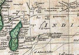 Nazareth Bank and Saya de Malha on a 1794 Samuel Dunn map section | |
| Country | Mauritius |
| Area | |
| • Total | 7,625 - 26,000 km2 (−2,414 sq mi) |
Geography
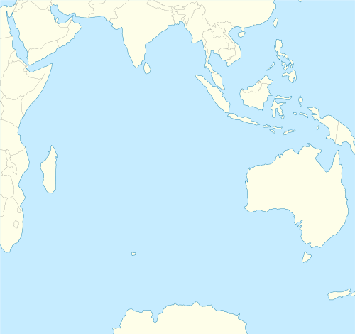
It lies about 1040 km east of northern Madagascar and 280 km south of Saya de Malha Bank. The closest land is Cargados Carajos shoals, a small and remote dependency of Mauritius located 140 km to the southwest. The Nazareth Bank is part of the vast undersea Mascarene Plateau[1] and of the Reunion hotspot track.[2]
The center of the bank is at 14°30′0.0″S 60°40′0.00″E. Its extent is about 176 km north-south and up to 87 km east-west, with a surface of about 11,000 km².[3] This undersea bank is administered by Mauritius.
gollark: Tagenkan ***SPOKE***.
gollark: You're not defining ignorant, learn or learn_anyways.
gollark: `unequip [side]`
gollark: ```2018/08/22 13:14:48 Duplicate detected: I had a drink without using a goblet. That's very annoying.— Sarvesh Febgireth, hammerer```
gollark: ```I was in a snow storm. It's annoying.— Limul ùshrirtarem, Woodworker```
See also
References
- Mascarene Plateau, Western Indian Ocean
- Geochronology of Basement Rocks from the Mascarene Plateau, the Chagos Bank and the Maldives Ridge
- Sources cite area figures between 7,625 and 26,000 km²
External links
Fishing industry by region | ||
|---|---|---|
| By country |  | |
| Fishing banks | ||
| By species | ||
| Other areas | ||
| Fisheries |  | |
|---|---|---|
| Fishing | ||
| Industry |
| |
| Recreation | ||
| Techniques | ||
| Tackle | ||
| Locations |
| |
Outer islands of Mauritius | |||||
|---|---|---|---|---|---|
| Outer islands | .svg.png) | ||||
| Islets |
| ||||
| Fishing banks | |||||
| |||||
| Subdivisions |
| | ||||||||||||
|---|---|---|---|---|---|---|---|---|---|---|---|---|---|---|
| Politics |
| |||||||||||||
| Economy | ||||||||||||||
| Society |
| |||||||||||||
This article is issued from Wikipedia. The text is licensed under Creative Commons - Attribution - Sharealike. Additional terms may apply for the media files.