Lowland, Tennessee
Lowland is an unincorporated community in Hamblen County, Tennessee, United States.
Lowland, Tennessee | |
|---|---|
Unincorporated community | |
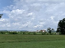 Site of former Liberty Fibers/Enka/BASF plant in Lowland | |
 Lowland  Lowland | |
| Coordinates: 36°09′29″N 83°12′30″W | |
| Country | United States |
| State | Tennessee |
| County | Hamblen |
| Elevation | 1,050 ft (320 m) |
| Time zone | UTC-5 (Eastern (EST)) |
| • Summer (DST) | UTC-4 (EDT) |
| ZIP code | 37778 |
| Area code(s) | 423 |
| GNIS feature ID | 1292236[1] |
History
Lowland has historically been the site of many synthetic fiber plants; the American Enka Company, BASF, and Liberty Fibers once operated on the same plant site in the community.[2][3][4][5]
Geography
Lowland is located near Tennessee State Route 160, Interstate 81 and the Norfolk Southern Railway 6.2 miles (10.0 km) southeast of Morristown.[6]
Lowland had a post office from February 1, 1949, to June 11, 2011; it still has its own ZIP code, 37778.[7][8]
The former industrial site of the Liberty Fibers/Enka/BASF plant and its adjacent wastewater treatment plant have since been annexed into the City of Morristown.[9]
Historic sites
The properties of Rural Mount and St. Paul Presbyterian Church in Lowland are both listed on the National Register of Historical Places.
References
- "Lowland". Geographic Names Information System. United States Geological Survey.
- "The Word for Corporations in Tennessee is 'Build'". New York Times. August 21, 1965. Retrieved February 12, 2015. – via New York Times (subscription required)
- "BASF to stop producing nylon polymer in Tenn". Women's Wear Daily. October 11, 1994. Archived from the original on June 10, 2014. Retrieved December 14, 2012. – via HighBeam Research (subscription required)
- "Liberty Fibers faces another shutdown". Newport Plain Talk. April 7, 2008. Archived from the original on December 2, 2013. Retrieved December 14, 2012.
- "Liberty Fibers Corp. Closes Plant, Files For Bankruptcy Protection". The Greeneville Sun. October 1, 2005. Archived from the original on July 28, 2020. Retrieved July 28, 2020.
- Hamblen County, Tennessee General Highway Map (PDF) (Map). Tennessee Department of Transportation. 2009. Archived from the original (PDF) on July 16, 2012. Retrieved November 22, 2012.
- United States Postal Service (2012). "USPS - Look Up a ZIP Code". Retrieved 2012-02-15.
- "Postmaster Finder - Post Offices by ZIP Code". United States Postal Service. Retrieved December 14, 2012.
- "Am I In Morristown City Limits?". Morristown-Hamblen GIS Group. Retrieved July 29, 2020.
Municipalities and communities of Hamblen County, Tennessee, United States | ||
|---|---|---|
| City | ||
| Town | ||
| Unincorporated communities | ||
| Footnotes | ‡This populated place also has portions in an adjacent county or counties | |