List of listed buildings in Muthill, Perth and Kinross
List
| Name | Location | Date Listed | Grid Ref. [note 1] | Geo-coordinates | Notes | LB Number [note 2] | Image |
|---|---|---|---|---|---|---|---|
| Muthill, Drummond Street (S), A. Fotheringham | 56°19′55″N 3°50′06″W | Category C(S) | 18142 |  | |||
| Muthill, The Cross. House Belonging To W. Macallister | 56°19′55″N 3°49′56″W | Category C(S) | 18164 | | |||
| Muthill, Drummond Street (N) Wm. Campbell's Property | 56°19′56″N 3°50′01″W | Category C(S) | 18168 | | |||
| Culdees, Stables | 56°19′28″N 3°47′56″W | Category B | 18050 | | |||
| Aldonie Cottage | 56°18′02″N 3°51′13″W | Category B | 18053 | | |||
| Muthill, Willoughby Street (S), Drummond Castle Property J. Mcculloch And W. Haldane Tenants | 56°19′43″N 3°49′48″W | Category B | 18055 | | |||
| Muthill, Willoughby Street (S), 'Ingleneuk' (Hutcheson) | 56°19′44″N 3°49′51″W | Category C(S) | 18061 | | |||
| The Croft, (Rosebank Cottage On Map) | 56°19′43″N 3°49′58″W | Category B | 18070 | | |||
| Drummond Castle, Keep | 56°20′26″N 3°52′18″W | Category B | 18078 | 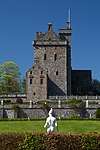 | |||
| Muthill, Willoughby Street (E), 'Lilyfield' (Mcilvride) | 56°19′49″N 3°49′56″W | Category C(S) | 18083 | | |||
| Muthill, Willoughby Street (E), Greenfield House (Mr T. Russell) | 56°19′47″N 3°49′55″W | Category C(S) | 18089 | | |||
| Muthill, Willoughby Street (N) Mcgregor | 56°19′44″N 3°49′48″W | Category C(S) | 18098 | | |||
| Muthill, Drummond Street (S), 'Lea Cottage' Mr. Culloch | 56°19′55″N 3°50′09″W | Category C(S) | 18104 | | |||
| Muthill, Willoughby Street (W), Former House, Now Store W. Of Post Office, The Property Of Cecil Taylor | 56°19′54″N 3°49′57″W | Category C(S) | 18106 | | |||
| Muthill, Willoughby Street (E), 'sydbar' (Mrs. Mackintosh) | 56°19′55″N 3°49′56″W | Category C(S) | 18111 | | |||
| Muthill, Willoughby Street (E), Tansey's Property | 56°19′54″N 3°49′56″W | Category C(S) | 18113 | | |||
| Muthill, Drummond Street (N) Surgery (Drs. Penny, Wishart & Mitchell) | 56°19′56″N 3°50′02″W | Category C(S) | 18124 | | |||
| Muthill, Drummond Street (S), Commercial Hotel | 56°19′55″N 3°50′01″W | Category C(S) | 18135 | | |||
| Muthill, Drummond Street (S), 'Garry Cottage' | 56°19′55″N 3°50′01″W | Category C(S) | 18136 | | |||
| Parkhead Farmhouse | 56°20′17″N 3°46′57″W | Category C(S) | 46523 | | |||
| Underhill Farmhouse | 56°19′34″N 3°50′14″W | Category B | 19852 | | |||
| Muthill, Drummond Street (S), Mrs. J. Malloch's Property | 56°19′55″N 3°50′04″W | Category C(S) | 18140 | | |||
| Muthill Old Parish Churchyard | 56°19′57″N 3°49′58″W | Category B | 18160 | | |||
| Muthill, The Cross, Property Belonging To Miss E. Williamson | 56°19′56″N 3°49′56″W | Category C(S) | 18166 | | |||
| Muthill, Willoughby Street (S) 'Boyton' | 56°19′43″N 3°49′49″W | Category C(S) | 18057 | | |||
| Muthill, Pitkellony Street, Property Occupied By Mrs. Sprunt And Mr. And Mrs Mccluskey | 56°19′44″N 3°49′52″W | Category C(S) | 18063 | | |||
| Strageath Mill Farm House | 56°20′42″N 3°48′37″W | Category B | 18074 | | |||
| Muthill, Willoughby Street (E), 'Newra House' (Mooney Kellog And Others) | 56°19′47″N 3°49′55″W | Category C(S) | 18087 | | |||
| Muthill, Drummond Street (S), | 56°19′55″N 3°50′07″W | Category C(S) | 18102 | | |||
| Muthill, Drummond Street (N) 3 Houses, Mcclelland And Miss Nish | 56°19′56″N 3°50′05″W | Category C(S) | 18127 | | |||
| Muthill, The Lurg | 56°18′44″N 3°50′38″W | Category C(S) | 51357 | | |||
| Muthill, Willoughby Street (W), 'Ruaig' Miss Orist | 56°19′51″N 3°49′57″W | Category C(S) | 19853 | | |||
| Muthill, Drummond Street (S), D. Scobie's Property (Tenant D. Gillies) | 56°19′55″N 3°49′59″W | Category C(S) | 19854 | | |||
| Muthill New Parish Church | 56°19′56″N 3°49′48″W | Category B | 18161 | 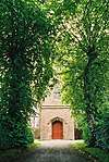 | |||
| Muthill New Parish Church, Gates | 56°19′56″N 3°49′52″W | Category C(S) | 18162 | | |||
| Muthill, Pitkellony Street, Cowan | 56°19′44″N 3°49′56″W | Category C(S) | 18067 | | |||
| Bennybeg Smithy | 56°20′51″N 3°50′36″W | Category B | 18076 | | |||
| Muthill, Willoughby Street (E), 'Laurel Cottage' (Mcmillan) | 56°19′49″N 3°49′56″W | Category C(S) | 18084 | | |||
| Muthill, Willoughby Street (S) 'Far Hills' (Formerly 'Garthland House') | 56°19′43″N 3°49′47″W | Category C(S) | 18100 | | |||
| Muthill, Drummond Street (S), Gambon Cottage D. Donaldson | 56°19′55″N 3°50′08″W | Category C(S) | 18103 | | |||
| Muthill, Willoughby Street (W), 'Nethercote' And Post Office | 56°19′54″N 3°49′56″W | Category C(S) | 18105 | | |||
| Muthill, Drummond Street (N) 'West End Cottage' Sweeney | 56°19′56″N 3°50′09″W | Category C(S) | 18131 | | |||
| Drummond Castle, Formal Garden | 56°20′22″N 3°52′15″W | Category A | 19883 | 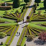 | |||
| Muthill, Drummond Street (S), A. Williamson | 56°19′55″N 3°50′02″W | Category C(S) | 18138 | | |||
| Muthill, Drummond Street (N) Macrae Building | 56°19′56″N 3°49′58″W | Category C(S) | 18167 | | |||
| Mill Of Steps Bridge, Over Machany Water | 56°18′51″N 3°50′29″W | Category B | 18051 | | |||
| Muthill, Willoughby Street (S), 'Arrascote' (Petrie) | 56°19′44″N 3°49′50″W | Category C(S) | 18058 | | |||
| Muthill, Willoughby Street (S), 'Leanna' Mrs. Robertson | 56°19′44″N 3°49′50″W | Category C(S) | 18060 | | |||
| Muthill, Pitkellony Street, Thomas Melville | 56°19′44″N 3°49′54″W | Category C(S) | 18065 | | |||
| Muthill, Pitkellony Street, Mr. Lang | 56°19′44″N 3°49′55″W | Category C(S) | 18066 | | |||
| Highlandman's Park, Rubble Retaining Wall And Dyke | 56°19′44″N 3°49′57″W | Category C(S) | 18069 | | |||
| Muthill, Willoughby Street (E), 'st. Ann's' (C. Mackintosh) | 56°19′51″N 3°49′56″W | Category C(S) | 18080 | | |||
| Muthill, Willoughby Street (E), 'Park House' (Mrs. Milroy) | 56°19′46″N 3°49′55″W | Category C(S) | 18090 | | |||
| Muthill, Willoughby Street (N), Maccraw | 56°19′45″N 3°49′51″W | Category C(S) | 18096 | | |||
| Muthill, Willoughby Street (N), 'Belmont' And 'Cottage Clare' | 56°19′44″N 3°49′49″W | Category C(S) | 18097 | | |||
| Muthill, Willoughby Street (W), 'Leny House' Anderson | 56°19′51″N 3°49′57″W | Category C(S) | 18110 | | |||
| Muthill, Willoughby Street (E), Whyte's Building | 56°19′53″N 3°49′55″W | Category C(S) | 18119 | | |||
| Muthill, Willoughby Street (E), (Miss Ness) | 56°19′52″N 3°49′55″W | Category C(S) | 18120 | | |||
| Muthill, Drummond Street (N) Property Owned By Wm. Campbell, Mcgregor Tenant | 56°19′56″N 3°50′02″W | Category C(S) | 18122 | | |||
| Muthill, Drummond Street (N) Younger 'Dilwara' | 56°19′56″N 3°50′03″W | Category C(S) | 18125 | | |||
| Muthill, Drummond Street, (N) Drummond Castle Property Tenanted By R. Taylor | 56°19′56″N 3°50′04″W | Category C(S) | 18126 | | |||
| Muthill, Drummond Street (N) Smith, Fletcher, Boyd & Steven | 56°19′56″N 3°50′08″W | Category C(S) | 18130 | | |||
| Pitkellony House, Walled Garden | 56°19′47″N 3°50′16″W | Category C(S) | 50899 | | |||
| Muthill, The Cross, 'Machany Cottage' | 56°19′55″N 3°49′55″W | Category C(S) | 19855 | | |||
| Thornhill, N.E. Section, Drummond Castle Policies | 56°20′18″N 3°52′32″W | Category C(S) | 18044 | | |||
| Drummond Bridge Over Machany Water | 56°19′14″N 3°52′51″W | Category B | 18052 | | |||
| Muthill, Pitkellony Street, 'Crossways' (Misses Mackie) | 56°19′44″N 3°49′54″W | Category B | 18064 | | |||
| Muthill, Willoughby Street (E), Watson 'Parkview' | 56°19′45″N 3°49′53″W | Category C(S) | 18093 | | |||
| Muthill, Willoughby Street (E.-W. Section - N.) 'Dunsinnane' (Rintoul) | 56°19′45″N 3°49′52″W | Category C(S) | 18095 | | |||
| Muthill, Willoughby Street (W), 'Polythack Cottage' | 56°19′53″N 3°49′57″W | Category C(S) | 18107 | | |||
| Muthill, Willoughby Street (W). Mackintosh | 56°19′53″N 3°49′56″W | Category C(S) | 18108 | | |||
| Muthill, Willoughby Street (E), Property E. Of 'The Roundel' Occupied By Mcainsh Gow And Dinnie | 56°19′53″N 3°49′55″W | Category C(S) | 18117 | | |||
| Muthill, Willoughby Street (E), 'The Roundel' Gow | 56°19′53″N 3°49′55″W | Category B | 18118 | | |||
| Muthill, Drummond Street (N) 'Cruachan' | 56°19′56″N 3°50′07″W | Category B | 18129 | | |||
| Muthill, Drummond Street, Taylor's Property | 56°19′56″N 3°50′00″W | Category C(S) | 18469 | | |||
| Muthill, Drummond Street (S), 'Diamond House' | 56°19′55″N 3°50′02″W | Category C(S) | 18137 | | |||
| Muthill Old Parish Church (A Ruin) | 56°19′57″N 3°49′58″W | Category A | 18159 | | |||
| Muthill, The Cross 'Old Schoolhouse' | 56°19′56″N 3°49′56″W | Category C(S) | 18165 | | |||
| Drummond Castle West Lodge | 56°20′24″N 3°53′01″W | Category B | 18045 | | |||
| Culdees Castle | 56°19′27″N 3°48′17″W | Category B | 18049 | | |||
| Muthill, Willoughby Street (S), 'Myrtle Cottage' Robertson | 56°19′44″N 3°49′50″W | Category C(S) | 18059 | | |||
| Dog Head Well, Highlandman's Park, At Junction Of Pitkellony Street And Willoughby Street | 56°19′44″N 3°49′54″W | Category B | 18068 | | |||
| Strageath Mill | 56°20′43″N 3°48′34″W | Category C(S) | 18075 | | |||
| Muthill, Willoughby Street (E), 'struthill House' (Stalker) | 56°19′47″N 3°49′55″W | Category C(S) | 18088 | | |||
| Muthill, Willoughby Street (E), 'st. John's Cottages' Haldane And Campbell | 56°19′45″N 3°49′53″W | Category C(S) | 18094 | | |||
| Muthill, Drummond Street (S), Mrs. Ballantine | 56°19′55″N 3°50′06″W | Category C(S) | 18101 | | |||
| Muthill, Willoughby Street (W), Masonic Lodge Property | 56°19′52″N 3°49′57″W | Category C(S) | 18109 | | |||
| Muthill, Willoughby Street (E) 'Casa Manda'. Mcainsh | 56°19′53″N 3°49′55″W | Category C(S) | 18116 | | |||
| Muthill, Drummond Street (S) Mrs. W. Tainsh | 56°19′55″N 3°49′58″W | Category C(S) | 18132 | | |||
| Muthill, Drummond Street (S) 'st. Nicholas' (Wm. Milne) | 56°19′55″N 3°49′58″W | Category C(S) | 18133 | | |||
| Dalliotfield | 56°20′07″N 3°49′40″W | Category C(S) | 50822 | | |||
| Wester Ochtermuthill | 56°19′44″N 3°53′44″W | Category B | 19851 | | |||
| Drummond Castle, Mansion | 56°20′27″N 3°52′14″W | Category B | 18042 | 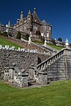 | |||
| Balloch Mill, Miller's House And Adjoining Buildings | 56°21′09″N 3°52′29″W | Category B | 18046 | | |||
| Balloch Mill, Threshing Mill | 56°21′08″N 3°52′30″W | Category C(S) | 18047 | | |||
| Balloch Mill, Former Mill Buildings | 56°21′08″N 3°52′27″W | Category C(S) | 18048 | | |||
| Muthill, K6 Telephone Kiosk Close To Old Parish Church | 56°19′55″N 3°49′56″W | Category B | 18054 | | |||
| Pitkellony Lodge, Thornhill House Including Dairy, Ancillary Building, Gates, Gatepiers And Boundary Walls | 56°19′45″N 3°50′00″W | Category C(S) | 18071 | | |||
| Drummond Castle Gates & East Lodge | 56°20′34″N 3°50′27″W | Category B | 18077 | | |||
| Muthill, Willoughby Street (E), 'Dunvegan' | 56°19′52″N 3°49′55″W | Category C(S) | 18079 | | |||
| Muthill, Willoughby Street (E), 'Ivydale' Ross | 56°19′50″N 3°49′56″W | Category C(S) | 18081 | | |||
| Muthill, Willoughby Street (E), Mrs. Corse | 56°19′50″N 3°49′56″W | Category C(S) | 18082 | | |||
| Muthill, Willoughby Street (E), 'Gowanlea' Miss M. Tainsh | 56°19′48″N 3°49′56″W | Category C(S) | 18086 | | |||
| Muthill, Willoughby Street (E), Drummond Cottage (Cameron, Drummond Cas. Property) | 56°19′54″N 3°49′55″W | Category C(S) | 18114 | | |||
| Muthill, Drummond Street (N) Property Owned By Mrs. J. Gow, Mcallister, Tenant | 56°19′56″N 3°50′02″W | Category C(S) | 18123 | | |||
| Muthill, Drummond Street (S) Mr Ginlay 'Hillview' | 56°19′55″N 3°49′59″W | Category C(S) | 18134 | | |||
| Pitkellony House | 56°19′49″N 3°50′13″W | Category C(S) | 50898 | | |||
| Muthill, Drummond Street (S), 'Drumbeg' (Owner: Cummings, Tenant: Burns) | 56°19′55″N 3°50′03″W | Category C(S) | 18139 | | |||
| Muthill, Drummond Street (S), Mrs. J. Malloch | 56°19′55″N 3°50′04″W | Category C(S) | 18141 | | |||
| St. James Episcopal Church, Muthill (Including Hall And Vestry) | 56°19′55″N 3°49′53″W | Category B | 18163 | | |||
| Drummond Castle - Statue Said To Be Of Jupiter On Avenue S. Of Castle | 56°20′14″N 3°52′11″W | Category B | 18043 | | |||
| Muthill, Willoughby Street (S), 'Dunbrae' Mrs. Westwood | 56°19′43″N 3°49′48″W | Category C(S) | 18056 | | |||
| Muthill, Willoughby Street (S), 'Auchindoir' (Now Mrs Clarke) Balmora L Castle | 56°19′44″N 3°49′52″W | Category C(S) | 18062 | | |||
| Underhill Steading | 56°19′35″N 3°50′15″W | Category C(S) | 18072 | | |||
| Bishop's Bridge Over Machany Water | 56°19′02″N 3°49′12″W | Category C(S) | 18073 | | |||
| Muthill, Willoughby Street (E), 'Parkside' | 56°19′48″N 3°49′56″W | Category C(S) | 18085 | | |||
| Muthill, Willoughby Street (E), 'Little Culdees' Miss Gibson | 56°19′46″N 3°49′54″W | Category B | 18091 | | |||
| Muthill, Willoughby Street (E), Drummond Castle Houses Tenanted By Mrs Mccurrach & Mrs. Birnie | 56°19′45″N 3°49′54″W | Category C(S) | 18092 | | |||
| Muthill, Willoughby Street (N), 'Viewfield' (Cooper) | 56°19′44″N 3°49′47″W | Category C(S) | 18099 | | |||
| Muthill, Willoughby Street (E), 'Lime Tree View' | 56°19′55″N 3°49′56″W | Category C(S) | 18112 | | |||
| Muthill, Willoughby Street (E), Mcdougal Property | 56°19′54″N 3°49′55″W | Category C(S) | 18115 | | |||
| Muthill, Willoughby Street (E), 'Victoria House' Miss Ellis | 56°19′52″N 3°49′55″W | Category C(S) | 18121 | | |||
| Muthill, Drummond Street (N) Stratton 'sundial' | 56°19′56″N 3°50′06″W | Category C(S) | 18128 | |
Key
The scheme for classifying buildings in Scotland is:
- Category A: "buildings of national or international importance, either architectural or historic; or fine, little-altered examples of some particular period, style or building type."[1]
- Category B: "buildings of regional or more than local importance; or major examples of some particular period, style or building type, which may have been altered."[1]
- Category C: "buildings of local importance; lesser examples of any period, style, or building type, as originally constructed or moderately altered; and simple traditional buildings which group well with other listed buildings."[1]
In March 2016 there were 47,288 listed buildings in Scotland. Of these, 8% were Category A, and 50% were Category B, with the remaining 42% being Category C.[2]
Notes
- Sometimes known as OSGB36, the grid reference (where provided) is based on the British national grid reference system used by the Ordnance Survey.
• "Guide to National Grid". Ordnance Survey. Retrieved 2007-12-12.
• "Get-a-map". Ordnance Survey. Retrieved 2007-12-17. - Historic Environment Scotland assign a unique alphanumeric identifier to each designated site in Scotland, for listed buildings this always begins with "LB", for example "LB12345".
gollark: It tries between 1 and 4 bytes and sees if any work.
gollark: It's not a length terminated int, just 1 to 4 bytes some endianness.
gollark: I have a C implementation.
gollark: If I remember right, the computers of the time weren't good enough to stand up to proper glorious length terminated strings.
gollark: Oh, I designed this format retroactively.
References
- All entries, addresses and coordinates are based on data from Historic Scotland. This data falls under the Open Government Licence
- "What is Listing?". Historic Environment Scotland. Retrieved 29 May 2018.
- Scotland's Historic Environment Audit 2016 (PDF). Historic Environment Scotland and the Built Environment Forum Scotland. pp. 15–16. Retrieved 29 May 2018.
This article is issued from Wikipedia. The text is licensed under Creative Commons - Attribution - Sharealike. Additional terms may apply for the media files.