List of listed buildings in Dunning, Perth and Kinross
List
| Name | Location | Date Listed | Grid Ref. [note 1] | Geo-coordinates | Notes | LB Number [note 2] | Image |
|---|---|---|---|---|---|---|---|
| Keltie Castle Bridge Over Keltie Burn | 56°18′05″N 3°36′19″W | Category C(S) | 5913 |  | |||
| 'Dunglas', Chalmers Street | 56°18′45″N 3°35′07″W | Category C(S) | 5925 | | |||
| 'Glenannia', 'Harry's Muir', 'Blair Cottage', Upper Granco Street | 56°18′45″N 3°35′05″W | Category C(S) | 5934 | | |||
| 'Fonab' Lower Granco Street | 56°18′47″N 3°35′09″W | Category C(S) | 5937 | | |||
| 'Harlaw', Lower Granco Street | 56°18′48″N 3°35′10″W | Category C(S) | 5940 | | |||
| Pitcairns House Including Gatepiers, Quadrant Walls And Boundary Walls To Forgandenny Road | 56°18′34″N 3°34′25″W | Category B | 5950 | | |||
| St. John's Masonic Lodge, Yetts Of Muckhart Road, Including Front Area Wall Gatepiers And Lampholder | 56°18′40″N 3°35′15″W | Category B | 5953 | | |||
| Fraser, Thimblerow, Bridge Of Earn Road | 56°18′42″N 3°35′09″W | Category C(S) | 5960 | | |||
| 'skyemore', Bridge Of Earn Road | 56°18′43″N 3°35′07″W | Category C(S) | 5966 | | |||
| County Council Houses, St. Serf's Terrace, Perth Road | 56°18′44″N 3°35′09″W | Category C(S) | 5967 | | |||
| Findlay, Perth Road | 56°18′46″N 3°35′08″W | Category C(S) | 5971 | | |||
| 'Kirkgate House' (Miss Fanning) And Mcnamee, Tron Square | 56°18′44″N 3°35′15″W | Category C(S) | 5977 | | |||
| Dunning Hotel, 1 Station Road, A. P. Arnot's Shop And 'Maule House', Station Road And Auchterarder Road | 56°18′45″N 3°35′19″W | Category C(S) | 5979 | | |||
| Alex Millar's, Kirkstyle Square | 56°18′44″N 3°35′14″W | Category C(S) | 5986 | | |||
| G. & M. Goodwin's Property, Tron Square And Yetts Of Muckhart Road | 56°18′45″N 3°35′16″W | Category C(S) | 6025 | | |||
| Thomson, Chalmers Street | 56°18′45″N 3°35′06″W | Category C(S) | 5927 | | |||
| War Memorial, Chalmers Street And Perth Road | 56°18′45″N 3°35′07″W | Category C(S) | 5928 | | |||
| Lawson And Nicholson, Upper Granco Street | 56°18′45″N 3°35′03″W | Category C(S) | 5930 | | |||
| 'Caber Feidh', Upper Granco Street | 56°18′44″N 3°35′03″W | Category C(S) | 5932 | | |||
| Gatepiers Of 'Old Bank House' | 56°18′48″N 3°35′09″W | Category C(S) | 5944 | | |||
| Newton Of Pitcairns School, North Block | 56°18′39″N 3°35′02″W | Category C(S) | 5948 | | |||
| Stewart's Property, Perth Road | 56°18′47″N 3°35′08″W | Category C(S) | 5973 | | |||
| Crow, Perth Road | 56°18′43″N 3°35′09″W | Category C(S) | 5974 | | |||
| 'Ardshiel', Auchterarder Road | 56°18′44″N 3°35′18″W | Category C(S) | 5983 | | |||
| Robertson And 'Crossways', Auchterarder Road And Yetts Of Muckhart Road | 56°18′44″N 3°35′17″W | Category C(S) | 5984 | | |||
| 'Thorntree Villa', (Miss E. Mailer's Property), Yetts Of Muckhart Road | 56°18′42″N 3°35′15″W | Category C(S) | 6000 | | |||
| Parish Churchyard, Walls, Monument And Session House | 56°18′45″N 3°35′14″W | Category B | 6019 | 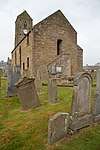 | |||
| Mr. Crow's Store, Kirk Wynd | 56°18′46″N 3°35′16″W | Category C(S) | 6021 | | |||
| J.S. Calderwood's Property, Kirk Wynd And Tron Square | 56°18′46″N 3°35′16″W | Category C(S) | 6022 | | |||
| Maggie Walls Monument | 56°18′32″N 3°36′29″W | Category B | 5911 | | |||
| Garvock House Burial Enclosure | 56°18′54″N 3°33′23″W | Category C(S) | 5917 | | |||
| Leadketty Farm House | 56°19′16″N 3°35′28″W | Category B | 5919 | | |||
| 'Grampian View', Chalmers Street | 56°18′45″N 3°35′06″W | Category C(S) | 5926 | | |||
| 'Hazelwood' And Adjoining Workshop. Upper Granco Street | 56°18′46″N 3°35′04″W | Category C(S) | 5931 | | |||
| Philp, Upper Granco Street | 56°18′45″N 3°35′05″W | Category C(S) | 5935 | | |||
| Hutchison And 'Cadzow', Lower Granco Street | 56°18′48″N 3°35′08″W | Category C(S) | 5941 | | |||
| 'Granco House', Lower Granco Street | 56°18′50″N 3°35′11″W | Category B | 5947 | | |||
| Newton Of Pitcairns School, South Block | 56°18′39″N 3°35′00″W | Category C(S) | 5949 | | |||
| D. & J. Henderson's, Bridgend (Bridge Of Earn Road) | 56°18′43″N 3°35′11″W | Category C(S) | 5955 | | |||
| 'Rowanbank', Thimblerow, Bridge Of Earn Road | 56°18′42″N 3°35′08″W | Category C(S) | 5958 | | |||
| Laing, Thimblerow, Bridge Of Earn Road | 56°18′42″N 3°35′09″W | Category C(S) | 5959 | | |||
| Boag, Auchterarder Road | 56°18′42″N 3°35′20″W | Category C(S) | 5980 | | |||
| Farquharson And Church Hall, Kirkstyle Square | 56°18′44″N 3°35′13″W | Category C(S) | 5987 | | |||
| Clark, Yetts Of Muckhart Road | 56°18′44″N 3°35′16″W | Category C(S) | 5992 | | |||
| 'shandene' (Storrar), Yetts Of Muckhart Road | 56°18′44″N 3°35′16″W | Category C(S) | 5994 | | |||
| 'Glenfoot' (Graham), Yetts Of Muckhart Road | 56°18′41″N 3°35′14″W | Category C(S) | 5996 | | |||
| 'Tron House', Tron Square | 56°18′45″N 3°35′17″W | Category C(S) | 6023 | | |||
| Duncrub Dovecot | 56°19′01″N 3°35′39″W | Category A | 5915 | | |||
| Baldinnies Farmhouse | 56°19′57″N 3°34′41″W | Category B | 5920 | | |||
| Whytock, Chalmers Street | 56°18′45″N 3°35′07″W | Category C(S) | 5924 | | |||
| Batchelor, Upper Granco Street | 56°18′44″N 3°35′03″W | Category C(S) | 5933 | | |||
| 'Kilard', Lower Granco Street | 56°18′48″N 3°35′09″W | Category C(S) | 5938 | | |||
| House (Aineas Dougal), Lower Granco Street | 56°18′48″N 3°35′09″W | Category B | 5943 | | |||
| Hollybank, Yetts Of Muckhart Road | 56°18′39″N 3°35′15″W | Category C(S) | 5952 | | |||
| Dr. Janet Mclaren's Surgery, Bridge Of Earn Road | 56°18′43″N 3°35′10″W | Category C(S) | 5957 | | |||
| 'Hillcrest' And 'sunnyside', Bridge Of Earn Road | 56°18′43″N 3°35′09″W | Category C(S) | 5963 | | |||
| James Crow, Perth Road | 56°18′45″N 3°35′09″W | Category C(S) | 5968 | | |||
| Kirkstyle Hotel, Kirkstyle Square | 56°18′44″N 3°35′13″W | Category B | 5985 | | |||
| Co-Operative House, Thorntree Square | 56°18′44″N 3°35′15″W | Category C(S) | 5989 | | |||
| Robertson's Bakehouse, Yetts Of Muckhart Road | 56°18′44″N 3°35′17″W | Category C(S) | 5993 | | |||
| 'Dalshian' (Wallace) Yetts Of Muckhart Road | 56°18′41″N 3°35′14″W | Category C(S) | 5997 | | |||
| J. Lester, Post Office Building, Tron Square | 56°18′45″N 3°35′16″W | Category C(S) | 6026 | | |||
| Kippen House Including Gatepiers And Quadrant Walls | 56°17′56″N 3°35′15″W | Category B | 51332 | | |||
| Mr. Philip's Property, Thimblerow, Bridge Of Earn Road | 56°18′42″N 3°35′10″W | Category C(S) | 5962 | | |||
| Thorntree Inn, Thorntree Square | 56°18′43″N 3°35′14″W | Category C(S) | 5988 | | |||
| 'Thorntree House', Thorntree Square | 56°18′43″N 3°35′16″W | Category B | 5991 | | |||
| 'Ladeside', Yetts Of Muckhart Road | 56°18′41″N 3°35′13″W | Category C(S) | 5999 | | |||
| 'straw House', Kirk Wynd (Empty: Mr. Crow) | 56°18′47″N 3°35′15″W | Category B | 6020 | | |||
| R. Arnott (Trading As D. Hogg), Tron Square And Station Road | 56°18′45″N 3°35′18″W | Category C(S) | 6024 | | |||
| Keltie Castle | 56°18′05″N 3°36′19″W | Category A | 5912 | | |||
| Thorntree Court, Off Yetts Of Muckhart Road | 56°18′43″N 3°35′17″W | Category C(S) | 67 | | |||
| J. Smith, Tron Square | 56°18′46″N 3°35′17″W | Category C(S) | 68 | | |||
| Duncrub Chapel, (Now Shed: Mr. Marshall) | 56°18′57″N 3°36′03″W | Category B | 5914 | | |||
| Inverdunning House | 56°19′39″N 3°34′33″W | Category B | 5918 | | |||
| Baldinnies Mill And Steading | 56°19′57″N 3°34′44″W | Category B | 5921 | | |||
| Broom, Smithy Filling Station Darleoch | 56°20′26″N 3°36′55″W | Category C(S) | 5922 | | |||
| 'Tarland' And 'Rose Cottage', Lower Granco Street | 56°18′47″N 3°35′08″W | Category C(S) | 5936 | | |||
| Coach House And Outbuildings Of Hollybank (Miss Fletcher), Yetts Of Muckhart Road | 56°18′40″N 3°35′14″W | Category C(S) | 5951 | | |||
| 'Clifton Bank', Bridge Of Earn Road | 56°18′43″N 3°35′08″W | Category C(S) | 5965 | | |||
| Dawson And Dixon, Perth Road | 56°18′45″N 3°35′08″W | Category C(S) | 5970 | | |||
| J. Mitchell, Auchterarder Road | 56°18′44″N 3°35′18″W | Category C(S) | 5982 | | |||
| House, Thorntree Square And Yetts Of Muckhart Road (Representatives Of Mrs. J. Miller) | 56°18′44″N 3°35′15″W | Category C(S) | 5990 | | |||
| Kippen Lodge | 56°18′02″N 3°35′05″W | Category C(S) | 51333 | | |||
| Garvock House | 56°18′58″N 3°33′22″W | Category B | 5916 | | |||
| 'The Knowes', Upper Granco Street And Bridge Of Earn Road. (Including Garden And Coach House) | 56°18′44″N 3°35′02″W | Category C(S) | 5929 | | |||
| 'Glengarry', Lower Granco Street | 56°18′48″N 3°35′10″W | Category C(S) | 5939 | | |||
| Dewar And Miss Adams, Lower Granco Street | 56°18′48″N 3°35′08″W | Category C(S) | 5942 | | |||
| 'Old Bank House' And Slater's Workshop, Lower Granco Street | 56°18′49″N 3°35′09″W | Category C(S) | 5945 | | |||
| Neave, Lower Granco Street | 56°18′49″N 3°35′10″W | Category B | 5946 | | |||
| 'Corshellach', Bridge Of Earn Road | 56°18′43″N 3°35′10″W | Category C(S) | 5956 | | |||
| Robson, Perth Road | 56°18′44″N 3°35′09″W | Category C(S) | 5975 | | |||
| 'Lynton', Chalmers Street | 56°18′44″N 3°35′08″W | Category C(S) | 66 | | |||
| Rossie Steading | 56°18′12″N 3°37′17″W | Category C(S) | 73 | | |||
| Clow Bridge Over Water Of May | 56°16′52″N 3°31′25″W | Category C(S) | 5923 | | |||
| Bridge Over Dunning Burn | 56°18′44″N 3°35′12″W | Category C(S) | 5954 | | |||
| Brown, Thimblerow, Bridge Of Earn Road | 56°18′41″N 3°35′09″W | Category C(S) | 5961 | | |||
| 'Bridgend', Bridge Of Earn Road | 56°18′43″N 3°35′08″W | Category C(S) | 5964 | | |||
| 'Dunearn', Perth Road | 56°18′45″N 3°35′08″W | Category C(S) | 5969 | | |||
| Stewart, Perth Road | 56°18′46″N 3°35′08″W | Category C(S) | 5972 | | |||
| 'Earnbank', Perth Road | 56°18′44″N 3°35′08″W | Category C(S) | 5976 | | |||
| Craigielea, Station Road | 56°18′45″N 3°35′19″W | Category C(S) | 5978 | | |||
| Town Hall, Auchterarder Road | 56°18′44″N 3°35′19″W | Category C(S) | 5981 | | |||
| Co-Operative Shop, Yetts Of Muckhart Road | 56°18′44″N 3°35′16″W | Category C(S) | 5995 | | |||
| Murray, Yetts Of Muckhart Road | 56°18′41″N 3°35′14″W | Category C(S) | 5998 | |
Key
The scheme for classifying buildings in Scotland is:
- Category A: "buildings of national or international importance, either architectural or historic; or fine, little-altered examples of some particular period, style or building type."[1]
- Category B: "buildings of regional or more than local importance; or major examples of some particular period, style or building type, which may have been altered."[1]
- Category C: "buildings of local importance; lesser examples of any period, style, or building type, as originally constructed or moderately altered; and simple traditional buildings which group well with other listed buildings."[1]
In March 2016 there were 47,288 listed buildings in Scotland. Of these, 8% were Category A, and 50% were Category B, with the remaining 42% being Category C.[2]
Notes
- Sometimes known as OSGB36, the grid reference (where provided) is based on the British national grid reference system used by the Ordnance Survey.
• "Guide to National Grid". Ordnance Survey. Retrieved 2007-12-12.
• "Get-a-map". Ordnance Survey. Retrieved 2007-12-17. - Historic Environment Scotland assign a unique alphanumeric identifier to each designated site in Scotland, for listed buildings this always begins with "LB", for example "LB12345".
gollark: Try making biodiesel.
gollark: Isn't aternos at least 0.3 bad?
gollark: Oh, I guess so.
gollark: Which implies antimemetics.
gollark: Well, you clearly erased <@528237610943119381>'s memory of the relevant scene somehow.
References
- All entries, addresses and coordinates are based on data from Historic Scotland. This data falls under the Open Government Licence
- "What is Listing?". Historic Environment Scotland. Retrieved 29 May 2018.
- Scotland's Historic Environment Audit 2016 (PDF). Historic Environment Scotland and the Built Environment Forum Scotland. pp. 15–16. Retrieved 29 May 2018.
This article is issued from Wikipedia. The text is licensed under Creative Commons - Attribution - Sharealike. Additional terms may apply for the media files.