List of listed buildings in Coupar Angus, Perth and Kinross
List
| Name | Location | Date Listed | Grid Ref. [note 1] | Geo-coordinates | Notes | LB Number [note 2] | Image |
|---|---|---|---|---|---|---|---|
| Abbey Churchyard | 56°32′38″N 3°15′53″W | Category B | 23127 |  | |||
| 3 Causewayend | 56°32′45″N 3°16′07″W | Category C(S) | 23141 | | |||
| Cumberland (Or Yeomanry Barracks, 2 Calton Street | 56°32′46″N 3°16′04″W | Category B | 23146 | | |||
| Union Bank Buildings And Bank House, Calton Street | 56°32′50″N 3°15′59″W | Category B | 23150 | | |||
| Keithick House | 56°31′56″N 3°17′50″W | Category A | 6170 | | |||
| Arthurstone House, Sundial No. 2 In Front Of Summer-House | 56°34′27″N 3°12′13″W | Category C(S) | 6159 | | |||
| Pleasance Farmhouse | 56°32′23″N 3°16′00″W | Category C(S) | 23132 | | |||
| "Millburn", George Street | 56°32′41″N 3°16′08″W | Category B | 23139 | | |||
| 7 Gray Street | 56°32′45″N 3°16′06″W | Category B | 23142 | | |||
| Keithick House, Stables And Steading | 56°31′59″N 3°18′04″W | Category B | 6142 | | |||
| Wester Balgersho Farmhouse | 56°31′48″N 3°16′53″W | Category C(S) | 6146 | | |||
| Viewbank, Farmhouse | 56°33′56″N 3°13′26″W | Category C(S) | 6151 | | |||
| Arthurstone House, Summer-House In Walled Garden | 56°34′28″N 3°12′13″W | Category C(S) | 6158 | | |||
| Union Street, Town Hall Including Boundary Walls | 56°32′49″N 3°15′56″W | Category C(S) | 51347 | | |||
| 1 Calton Street | 56°32′47″N 3°16′04″W | Category C(S) | 23148 | | |||
| "Dalblair", Union Street | 56°32′48″N 3°16′00″W | Category C(S) | 23151 | | |||
| "Beech Hill Mansion House", Beech Hill Road | 56°32′56″N 3°16′12″W | Category B | 23153 | | |||
| Ardler Manse (Formerly) | 56°33′52″N 3°11′48″W | Category B | 6167 | | |||
| Keithick South Lodge | 56°31′51″N 3°17′20″W | Category B | 6143 | | |||
| Bridge Of Couttie | 56°33′09″N 3°17′07″W | Category B | 6148 | | |||
| Larghan House | 56°33′09″N 3°15′27″W | Category B | 6149 | | |||
| Isla Park | 56°33′22″N 3°14′44″W | Category B | 6150 | | |||
| Y.W.C.A., Union Street, Former Original Secession Church | 56°32′45″N 3°16′02″W | Category B | 23134 | | |||
| Masonic Buildings (St. John Operative No. 105), Gray Street | 56°32′45″N 3°16′05″W | Category B | 23143 | | |||
| "Princeland", Blairgowrie Road | 56°33′04″N 3°16′00″W | Category B | 23152 | | |||
| Keithick, North Lodge | 56°32′08″N 3°18′25″W | Category B | 6169 | | |||
| Arthurstone House, Sundial No. 3 In Front Of Greenhouse | 56°34′28″N 3°12′10″W | Category B | 6160 | | |||
| Arthurstone House Castle Folly And Greenhouse | 56°34′28″N 3°12′10″W | Category B | 6161 | | |||
| Arthurstone House, Dovecot | 56°34′28″N 3°12′04″W | Category B | 6163 | | |||
| Arthurstone House, Sundial No. 1 At S.E. Front Of House | 56°34′21″N 3°12′13″W | Category B | 5707 | | |||
| Royal Hotel, High Street And 2 George Street (Formerly Defiance Inn And Assembly Rooms) | 56°32′43″N 3°16′03″W | Category B | 23138 | | |||
| 2 Hay Street | 56°32′47″N 3°16′05″W | Category B | 23145 | | |||
| "Aviemore", Calton Street | 56°32′49″N 3°16′01″W | Category C(S) | 23149 | | |||
| Keithick House Sundial | 56°32′00″N 3°17′58″W | Category C(S) | 6141 | | |||
| Kemphill, Farmhouse | 56°32′39″N 3°17′33″W | Category C(S) | 6144 | | |||
| Kinloch House, (Now Hotel) | 56°35′07″N 3°11′38″W | Category B | 6154 | | |||
| Cistercian Abbey, Remains Of, Queen Street | 56°32′35″N 3°15′52″W | Category B | 23125 | 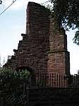 | |||
| The Steeple, Queen Street | 56°32′41″N 3°15′59″W | Category B | 23128 | | |||
| 18, 20, 22 Commercial Street | 56°32′46″N 3°16′04″W | Category C(S) | 23144 | | |||
| 4, 6 Calton Street | 56°32′47″N 3°16′03″W | Category B | 23147 | | |||
| "Gartloch Bank", Bogside Road | 56°32′52″N 3°16′28″W | Category B | 23154 | | |||
| Kinloch House, Steading | 56°35′04″N 3°11′45″W | Category B | 6152 | | |||
| Abbey Church, Parish Church Of Coupar Angus, Queen Street | 56°32′38″N 3°15′53″W | Category B | 23126 | 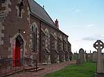 | |||
| Strathmore Hotel, Queen Street | 56°32′42″N 3°16′00″W | Category B | 23129 | | |||
| "Klydon House", Union Street | 56°32′45″N 3°15′59″W | Category B | 23133 | | |||
| N.E. Corner, The Cross, Commercial Street And Union Street (Formerly 1 Commercial Street) | 56°32′44″N 3°16′02″W | Category C(S) | 23136 | | |||
| Ardler Churchyard, Carmichael Enclosure | 56°33′49″N 3°11′50″W | Category C(S) | 6166 | | |||
| Kemphill, Steading | 56°32′39″N 3°17′25″W | Category C(S) | 6145 | | |||
| Kinloch House, Walled Garden And Sundial | 56°35′07″N 3°11′40″W | Category B | 6153 | | |||
| Arthurstone House, 'Antiquarian Corner' At N.W. Corner Of Walled Garden | 56°34′27″N 3°12′14″W | Category B | 6162 | | |||
| Ardler Church | 56°33′49″N 3°11′52″W | Category B | 6164 | _-_from_back_gate.jpg) | |||
| Abbeyhill, Precinct Street | 56°32′35″N 3°16′00″W | Category B | 23130 | | |||
| S.E. Corner, The Cross, High Street And Union Street | 56°32′44″N 3°16′02″W | Category C(S) | 23135 | | |||
| 3 Commercial Street | 56°32′45″N 3°16′03″W | Category B | 23137 | | |||
| Ardler Churchyard, Railings And Gates | 56°33′49″N 3°11′52″W | Category C(S) | 6165 | | |||
| Ardler (Formerly Washington) School | 56°33′49″N 3°11′50″W | Category C(S) | 6168 | | |||
| Balgersho House | 56°31′55″N 3°16′02″W | Category B | 6147 | | |||
| Arthurstone House | 56°34′21″N 3°12′14″W | Category B | 6155 | | |||
| Arthurstone House, Ice-House | 56°34′23″N 3°12′14″W | Category C(S) | 6156 | | |||
| Arthurstone House, Walled Garden | 56°34′27″N 3°12′09″W | Category C(S) | 6157 | |
Key
The scheme for classifying buildings in Scotland is:
- Category A: "buildings of national or international importance, either architectural or historic; or fine, little-altered examples of some particular period, style or building type."[1]
- Category B: "buildings of regional or more than local importance; or major examples of some particular period, style or building type, which may have been altered."[1]
- Category C: "buildings of local importance; lesser examples of any period, style, or building type, as originally constructed or moderately altered; and simple traditional buildings which group well with other listed buildings."[1]
In March 2016 there were 47,288 listed buildings in Scotland. Of these, 8% were Category A, and 50% were Category B, with the remaining 42% being Category C.[2]
Notes
- Sometimes known as OSGB36, the grid reference (where provided) is based on the British national grid reference system used by the Ordnance Survey.
• "Guide to National Grid". Ordnance Survey. Retrieved 12 December 2007.
• "Get-a-map". Ordnance Survey. Retrieved 17 December 2007. - Historic Environment Scotland assign a unique alphanumeric identifier to each designated site in Scotland, for listed buildings this always begins with "LB", for example "LB12345".
gollark: OIR™ has one.
gollark: How did it do *that*?
gollark: ++remind 2h fix
gollark: ++magic reload_ext irc_link
gollark: How does it keep *doing* that?
References
- All entries, addresses and coordinates are based on data from Historic Scotland. This data falls under the Open Government Licence
- "What is Listing?". Historic Environment Scotland. Retrieved 29 May 2018.
- Scotland's Historic Environment Audit 2016 (PDF). Historic Environment Scotland and the Built Environment Forum Scotland. pp. 15–16. Retrieved 29 May 2018.
This article is issued from Wikipedia. The text is licensed under Creative Commons - Attribution - Sharealike. Additional terms may apply for the media files.