List of listed buildings in Kenmore, Perth and Kinross
List
| Name | Location | Date Listed | Grid Ref. [note 1] | Geo-coordinates | Notes | LB Number [note 2] | Image |
|---|---|---|---|---|---|---|---|
| Acharn Cottages To North Of B Road From Killin To Kenmore At Acharn | 56°34′13″N 4°01′31″W | Category C(S) | 13803 |  | |||
| Kenmore Gate To Taymouth Castle, E. Side Of Square, With Flanking Walls On Either Side | 56°35′07″N 3°59′54″W | Category B | 13807 | 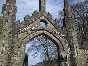 | |||
| Masonic Hall, N. Side Of Square | 56°35′07″N 3°59′57″W | Category B | 12121 | | |||
| Lawers Church | 56°31′41″N 4°09′06″W | Category B | 13806 | | |||
| Taymouth Castle | 56°35′41″N 3°58′53″W | Category A | 12093 | | |||
| Isle Of Loch Tay | 56°35′02″N 4°00′37″W | Category B | 12103 | | |||
| Bridge Over Allt A' Mhoirneas Near Rynachulig | 56°29′52″N 4°15′02″W | Category C(S) | 12110 | | |||
| Nurses' Cottage S. Side Of Square | 56°35′05″N 3°59′57″W | Category C(S) | 12128 | | |||
| Mrs. Mcdiarmid, The Brae, E. Side | 56°35′04″N 3°59′52″W | Category B | 12130 | | |||
| Kenmore Park - Wall Running From Council Housing At The Brae To Near The Killin - Aberfeldy Road Junction | 56°34′54″N 3°59′45″W | Category C(S) | 12133 | | |||
| Deuchar, The Brae, W. Side | 56°35′06″N 3°59′55″W | Category C(S) | 12134 | | |||
| Bridge Cottage (Former Orphanage) | 56°35′07″N 4°00′07″W | Category B | 12135 | | |||
| The Boathouse (Hotel Accommodation) | 56°35′07″N 4°00′00″W | Category C(S) | 12136 | | |||
| Dairy Byre, Taymouth | 56°35′13″N 3°59′10″W | Category B | 44966 | | |||
| Acharn, Fernbank | 56°34′10″N 4°01′39″W | Category B | 12434 | | |||
| Acharn, Pine Cottage | 56°34′10″N 4°01′33″W | Category B | 12085 | | |||
| The Mains Kenmore | 56°35′19″N 4°00′08″W | Category B | 12087 | | |||
| The Fort | 56°35′30″N 3°58′20″W | Category B | 12095 | | |||
| Chinese Bridge | 56°35′48″N 3°59′05″W | Category A | 12097 | .jpg) | |||
| Old Toll House. Lawers | 56°31′59″N 4°08′53″W | Category C(S) | 12105 | | |||
| Ardeonaig Church (Disused) (At The Old Manse) | 56°30′22″N 4°08′35″W | Category B | 12111 | | |||
| Parish Churchyard Wall And Wall Running N.W. From It To Grounds Of Bridge House | 56°35′04″N 4°00′04″W | Category C(S) | 12119 | | |||
| Mr Mcintyre, S. Side Of Square | 56°35′05″N 3°59′56″W | Category C(S) | 12126 | | |||
| Empty Cottage, S. Side Of Square | 56°35′05″N 3°59′58″W | Category C(S) | 12129 | | |||
| Empty Cottage, The Brae, E. Side | 56°35′04″N 4°00′03″W | Category B | 12131 | | |||
| 'Maxwell's Temple', Or 'The Cross' | 56°35′23″N 3°59′43″W | Category A | 13804 | | |||
| Urn At Termination Of Dairy Drive (Marked 'Monument' On O.S. Map) | 56°35′24″N 3°59′21″W | Category B | 13805 | | |||
| Portbane | 56°35′04″N 3°59′58″W | Category B | 12084 | | |||
| The Tower | 56°35′12″N 3°58′13″W | Category B | 12086 | | |||
| Taymouth Dairy And Terrace On West | 56°35′21″N 3°59′19″W | Category A | 12091 | | |||
| Fort Lodge | 56°35′28″N 3°58′18″W | Category A | 12096 | | |||
| Rustic Lodge | 56°36′25″N 3°58′26″W | Category A | 12100 | | |||
| Lawers Mill (Formerly Grain Mill) | 56°31′58″N 4°08′55″W | Category B | 12107 | | |||
| Remony | 56°34′19″N 4°01′05″W | Category B | 12115 | | |||
| The Beeches (Former Lodge Of Taymouth Castle) | 56°35′11″N 4°00′06″W | Category C(S) | 12139 | | |||
| Ice House, Taymouth | 56°35′44″N 3°58′52″W | Category B | 44965 | | |||
| Edramucky, Steading, Aqueduct And Water Wheel | 56°29′52″N 4°14′39″W | Category B | 12109 | | |||
| Kenmore Hotel, N Side Of Square | 56°35′07″N 3°59′57″W | Category B | 12122 | | |||
| R.D. Davidson (Post Office) S. Side Of Square | 56°35′06″N 3°59′55″W | Category C(S) | 12125 | | |||
| Manse Of Kenmore | 56°34′45″N 3°59′58″W | Category C(S) | 12140 | | |||
| Bridge Over Taymouth Burn Near Gravel Pits | 56°35′37″N 3°58′30″W | Category B | 12094 | | |||
| Delarb Rustic Lodge And Gatepiers | 56°35′01″N 4°00′56″W | Category B | 12102 | | |||
| Haugh Cottages, Acharn | 56°34′11″N 4°01′40″W | Category B | 12112 | | |||
| Bridge Carrying Aberfeldy - Kenmore Road Over Taymouth Burn | 56°35′05″N 3°58′57″W | Category B | 12088 | | |||
| Apollo's Temple | 56°35′10″N 3°59′09″W | Category B | 12089 | | |||
| Rock Lodge | 56°35′51″N 3°59′10″W | Category B | 12098 | | |||
| Star Battery, Inchadney | 56°35′43″N 3°58′31″W | Category B | 12099 | | |||
| Walled Garden | 56°35′13″N 4°00′21″W | Category B | 12101 | | |||
| Old Church, Lawers | 56°31′42″N 4°08′29″W | Category B | 12108 | | |||
| West House (Hotel Property) N. Side Of Square | 56°35′07″N 3°59′57″W | Category C(S) | 12120 | | |||
| Library And Librarian's House, N. Side Of Square, With Wall At Rear On W | 56°35′07″N 3°59′55″W | Category B | 12123 | | |||
| Miss Mcandrew, The Brae, E. Side | 56°35′04″N 3°59′58″W | Category B | 12132 | | |||
| Lawers Smithy | 56°31′58″N 4°08′57″W | Category C(S) | 12433 | | |||
| Bridge Over Taymouth Burn, E. Of Apollo's Temple | 56°35′12″N 3°59′01″W | Category B | 12090 | | |||
| Ramparts On River Bank S.W. Of Taymouth Castle | 56°35′33″N 3°59′04″W | Category B | 12092 | | |||
| Lawers Mill Bridge Over Dubh Eas | 56°31′59″N 4°08′54″W | Category C(S) | 12106 | | |||
| The Old Mill, Acharn, (Lochtayside Crafts) | 56°34′12″N 4°01′34″W | Category C(S) | 12113 | | |||
| Acharn Hermitage | 56°33′51″N 4°01′29″W | Category C(S) | 12114 | | |||
| Parish Church | 56°35′05″N 4°00′02″W | Category B | 12118 | 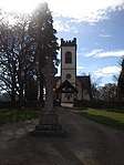 | |||
| Hotel Annexe And Gate House, S. Side Of Square | 56°35′06″N 3°59′53″W | Category C(S) | 12124 | | |||
| Mr Roy S. Side Of Square | 56°35′05″N 3°59′57″W | Category C(S) | 12127 | | |||
| Gate And Wall Running From S. Approach Of Bridge To Boathouse | 56°35′07″N 4°00′04″W | Category B | 12137 | | |||
| Kenmore Bridge Over River Tay | 56°35′09″N 4°00′07″W | Category A | 12138 | |
Key
The scheme for classifying buildings in Scotland is:
- Category A: "buildings of national or international importance, either architectural or historic; or fine, little-altered examples of some particular period, style or building type."[1]
- Category B: "buildings of regional or more than local importance; or major examples of some particular period, style or building type, which may have been altered."[1]
- Category C: "buildings of local importance; lesser examples of any period, style, or building type, as originally constructed or moderately altered; and simple traditional buildings which group well with other listed buildings."[1]
In March 2016 there were 47,288 listed buildings in Scotland. Of these, 8% were Category A, and 50% were Category B, with the remaining 42% being Category C.[2]
Notes
- Sometimes known as OSGB36, the grid reference (where provided) is based on the British national grid reference system used by the Ordnance Survey.
• "Guide to National Grid". Ordnance Survey. Retrieved 2007-12-12.
• "Get-a-map". Ordnance Survey. Retrieved 2007-12-17. - Historic Environment Scotland assign a unique alphanumeric identifier to each designated site in Scotland, for listed buildings this always begins with "LB", for example "LB12345".
gollark: Hmm...
gollark: But nobody remembers that, I'm just "the potatOS guy".
gollark: Anyway, I've made somewhat better-targeted-than-usual lasering, a cool door system, automatic inventory clearing, a haskell interpreter*, a dynmap player tracker, rednet exploits, a fixed rednet repeater, RCEoR/S, PaintEncode, Lolcrypt, useful terminal-streaming things, command-computer game of life floorboards, wireless printing, a cool screensaver, augmented reality, convenient modemless communication, and an easy-to-use trilateration system.
gollark: It was originally 14 or so because squid.
gollark: `You are muted and cannot speak for 4 days, 20 hours, 27 minutes, 59 seconds.`
References
- All entries, addresses and coordinates are based on data from Historic Scotland. This data falls under the Open Government Licence
- "What is Listing?". Historic Environment Scotland. Retrieved 29 May 2018.
- Scotland's Historic Environment Audit 2016 (PDF). Historic Environment Scotland and the Built Environment Forum Scotland. pp. 15–16. Retrieved 29 May 2018.
This article is issued from Wikipedia. The text is licensed under Creative Commons - Attribution - Sharealike. Additional terms may apply for the media files.