List of listed buildings in Blairgowrie And Rattray, Perth and Kinross
This is a list of listed buildings in the parish of Blairgowrie And Rattray in Perth and Kinross, Scotland.
List
| Name | Location | Date Listed | Grid Ref. [note 1] | Geo-coordinates | Notes | LB Number [note 2] | Image |
|---|---|---|---|---|---|---|---|
| Kirk Wynd, Tulach Including Ancillary Buildings, Boundary Walls, Gatepiers And Gates | 56°35′41″N 3°20′27″W | Category B | 22291 |  | |||
| 23 - 27 (Odd Nos) High Street | 56°35′33″N 3°20′24″W | Category C(S) | 22295 | | |||
| 20 And 22 Brown Street | 56°35′33″N 3°20′28″W | Category B | 22307 | | |||
| John Street, St Stephen's Roman Catholic Primary School Including Boundary Walls, Gatepiers And Gates | 56°35′33″N 3°20′42″W | Category B | 22313 | | |||
| 29 And 30 Wellmeadow, Bank Buildings | 56°35′29″N 3°20′15″W | Category B | 22319 | | |||
| 31, 32 And 33 Wellmeadow | 56°35′29″N 3°20′15″W | Category B | 22320 | | |||
| Rattray (New), Mount Ericht Road, Bengarth Including Ancillary Building, Boundary Walls And Gatepiers | 56°35′37″N 3°20′03″W | Category C(S) | 22326 | | |||
| Emma Terrace, Brackenbrae Including Gatepiers, Boundary Walls And Railings | 56°35′27″N 3°20′48″W | Category C(S) | 49422 | | |||
| 17 And 19 Newton Street Including Boundary Walls, Railings And Gates | 56°35′27″N 3°20′36″W | Category C(S) | 49437 | | |||
| Newton Street, Newton Castle, Old Stables And Steading | 56°35′32″N 3°21′03″W | Category B | 49440 | | |||
| 128 Perth Road, Garfield House Including Boundary Walls, Railings, Gates And Pier | 56°35′10″N 3°20′40″W | Category C(S) | 49443 | | |||
| Rattray (New), Balmoral Road, Rosebank House Including Ancillary Building, Gatepiers And Boundary Walls | 56°35′47″N 3°20′09″W | Category C(S) | 49454 | | |||
| 7 Reform Street, Blairgowrie Printers | 56°35′28″N 3°20′26″W | Category B | 49477 | | |||
| 53 Allan Street, Royal Hotel | 56°35′35″N 3°20′20″W | Category B | 22293 | | |||
| 26 Brown Street | 56°35′34″N 3°20′30″W | Category C(S) | 22306 | | |||
| 46 Leslie Street, Council Offices | 56°35′28″N 3°20′18″W | Category B | 22316 | | |||
| 28 - 32 (Even Nos) Allan Street | 56°35′33″N 3°20′19″W | Category C(S) | 49418 | | |||
| John Street, St Stephen's Roman Catholic Church | 56°35′31″N 3°20′28″W | Category B | 49432 | | |||
| Newton Street, Embden House Including Boundary Walls | 56°35′30″N 3°20′53″W | Category C(S) | 49439 | | |||
| 14 - 18 (Even Nos) Perth Street Including Boundary Walls | 56°35′27″N 3°20′27″W | Category C(S) | 49445 | | |||
| Rattray New, Hatton Road, Glenshieling House Including Boundary Walls And Gatepiers | 56°36′01″N 3°20′18″W | Category C(S) | 49469 | | |||
| Rattray (Old), New Road, Eastfield House | 56°35′43″N 3°19′25″W | Category C(S) | 49474 | | |||
| 9 Reform Street, Scotcrest Including Boundary Walls | 56°35′28″N 3°20′25″W | Category C(S) | 49478 | | |||
| Shaw Street, Greenbank Including Ancillary Building And Gatepiers | 56°35′17″N 3°20′46″W | Category C(S) | 49479 | | |||
| Upper Allan Street, Gorsehill Including Boundary Walls, Gatepiers And Gate | 56°35′41″N 3°20′30″W | Category C(S) | 49481 | | |||
| Westpark Road, Dalmor And Westerton Including Boundary Walls, Railings And Gates | 56°35′03″N 3°20′46″W | Category C(S) | 49489 | | |||
| 13 Brown Street, St Catharine's House | 56°35′34″N 3°20′27″W | Category C(S) | 22301 | | |||
| 7 George Street And 17 Brown Street | 56°35′34″N 3°20′29″W | Category B | 22302 | | |||
| 28 Brown Street | 56°35′34″N 3°20′31″W | Category B | 22305 | | |||
| Brown Street, Town Hall | 56°35′32″N 3°20′25″W | Category C(S) | 22312 | | |||
| 14 - 20 (Even Nos) Leslie Street, The Dome Restaurant | 56°35′30″N 3°20′16″W | Category B | 22315 | | |||
| 26, 27 And 28 Wellmeadow | 56°35′29″N 3°20′15″W | Category B | 22318 | | |||
| Wellmeadow Gardens, War Memorial | 56°35′30″N 3°20′13″W | Category A | 22321 | 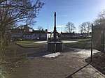 | |||
| Rattray (Old), High Street, Rattray Church Of Scotland Parish Church, Graveyard, Walls, Gatepiers And Gates | 56°35′46″N 3°19′16″W | Category C(S) | 22329 | | |||
| 13, 15 And 15A Allan Street | 56°35′33″N 3°20′16″W | Category C(S) | 49416 | | |||
| Emma Terrace, St Mary's Old Manse Including Ancillary Building, Boundary Walls And Gates | 56°35′26″N 3°20′50″W | Category B | 49423 | | |||
| Ericht Lane, Police Station Including Boundary Walls, Gatepiers And Railings | 56°35′30″N 3°20′19″W | Category C(S) | 49424 | | |||
| George Street, Wingate And Northneuk Including Boundary Walls, Railings And Gates | 56°35′27″N 3°20′33″W | Category C(S) | 49425 | | |||
| 1 High Street | 56°35′35″N 3°20′21″W | Category C(S) | 49426 | | |||
| 3 - 9 (Odd Nos) High Street | 56°35′34″N 3°20′22″W | Category C(S) | 49427 | | |||
| James Street, Blairgowrie Church Of Scotland Parish Church And Church Hall With Boundary Walls, Railings And Gates | 56°35′36″N 3°20′32″W | Category B | 49430 | | |||
| Keay Street, Drumsheen Including Gate, Gatepiers And Railings | 56°35′32″N 3°20′48″W | Category B | 49433 | | |||
| Lower Mill Street, Riverside Granary | 56°35′34″N 3°20′13″W | Category C(S) | 49436 | | |||
| Newton Terrace, Bush House Including Ancillary Building, Boundary Walls And Railings | 56°35′39″N 3°20′33″W | Category C(S) | 49441 | | |||
| Rattray (New), Mount Ericht Road, Woodville Including Boundary Walls, Gatepiers And Railings | 56°35′38″N 3°20′04″W | Category C(S) | 49473 | | |||
| 13A Wellmeadow | 56°35′31″N 3°20′13″W | Category C(S) | 49485 | | |||
| Kirk Wynd, Hill Church Including Boundary Walls, Gatepiers And Gates | 56°35′43″N 3°20′25″W | Category B | 22288 | | |||
| 31 - 37 (Odd Nos) High Street Former Institute And Library | 56°35′32″N 3°20′25″W | Category B | 22296 | | |||
| Brown Street, Old Bank House Including Ancillary Buildings, Gatepiers, Boundary Walls And Railings | 56°35′34″N 3°20′32″W | Category B | 22304 | | |||
| Rattray (New), Riverside Road, Ericht Bank Including Ancillary Buildings, Boundary Walls And Gatepiers | 56°35′34″N 3°20′05″W | Category B | 22323 | | |||
| Rattray (New), Ashgrove Road, Loon Brae Including Boundary Walls And Gatepiers | 56°35′32″N 3°19′52″W | Category B | 22327 | | |||
| Rattray (Old), High Street, Rattray Church Of Scotland Parish Church | 56°35′46″N 3°19′16″W | Category B | 22328 | | |||
| Rattray (New), Balmoral Road, Linnkeith House (Flats 1 To 4 Inclusive) And Linnkeith Cottage | 56°35′53″N 3°20′19″W | Category B | 22331 | | |||
| Keay Street, The Shieling Including Ancillary Building And Gate | 56°35′29″N 3°20′35″W | Category B | 48639 | | |||
| Coupar Angus Road, Altamount Lodge | 56°35′16″N 3°20′12″W | Category C(S) | 49421 | | |||
| 17 And 19 Perth Street, Irvine's Butcher And Knock Ma Har | 56°35′27″N 3°20′29″W | Category C(S) | 49444 | | |||
| Rattray (New), Ashgrove Road, The Haugh Including Coach House, Garden Store, Boundary Walls And Gatepiers | 56°35′18″N 3°19′44″W | Category C(S) | 49447 | | |||
| Kirkwynd, Hill Church Graveyard | 56°35′42″N 3°20′23″W | Category B | 22289 | | |||
| Reform Street, St Mary's South Church (Formerly Church Of Scotland) Including Church Hall | 56°35′25″N 3°20′19″W | Category B | 48970 | | |||
| 14, A, B, C And D Allan Street, Royal Bank Of Scotland | 56°35′32″N 3°20′18″W | Category B | 49417 | | |||
| Rattray (New), Hatton Road, Buchanan House Including Boundary Walls And Gatepier | 56°35′53″N 3°20′05″W | Category C(S) | 49456 | | |||
| Rattray (New), Hatton Road, The Marfield | 56°35′52″N 3°19′56″W | Category C(S) | 49471 | | |||
| Rattray (Old), New Road, Mansefield Including Ancillary Building And Boundary Walls | 56°35′44″N 3°19′21″W | Category C(S) | 49475 | | |||
| Tannage Street, Warehouse | 56°35′29″N 3°20′07″W | Category C(S) | 49480 | | |||
| 21, 22 And 23 Wellmeadow | 56°35′30″N 3°20′16″W | Category C(S) | 49488 | | |||
| Newton Street, Newton Castle | 56°35′31″N 3°21′01″W | Category A | 22314 | 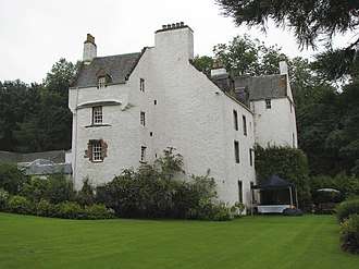 | |||
| 24 And 25 Wellmeadow | 56°35′30″N 3°20′16″W | Category C(S) | 22317 | | |||
| Coupar Angus Road, Altamount House Hotel Including Gatepiers, Boundary Walls And Railings | 56°35′09″N 3°20′11″W | Category B | 22333 | | |||
| Coupar Angus Road, Altamount House Hotel, Courtyard | 56°35′10″N 3°20′11″W | Category C(S) | 49419 | | |||
| 39 - 43 (Odd Nos) High Street Including Boundary Wall | 56°35′32″N 3°20′25″W | Category C(S) | 49429 | | |||
| Newton Street, Adylinn Including Boundary Walls, Railings And Gate | 56°35′26″N 3°20′36″W | Category C(S) | 49438 | | |||
| Perth Road, Duncraggan | 56°34′58″N 3°20′44″W | Category B | 49442 | | |||
| Rattray (New), Balmoral Road, Balmoral Hotel | 56°35′36″N 3°19′57″W | Category C(S) | 49448 | | |||
| Rattray (New), Balmoral Road, Mount Ericht Including Walled Garden, Courtyard With Ancillary Buildings, Boundary Walls, Gatepiers And Gates | 56°35′35″N 3°19′59″W | Category C(S) | 49451 | | |||
| Rattray (New), Braes Road, Croft-Na-Coille Including Boundary Walls And Gatepiers | 56°35′35″N 3°19′46″W | Category C(S) | 49455 | | |||
| Rattray (New), High Street, Elsham | 56°35′38″N 3°19′52″W | Category C(S) | 49472 | | |||
| Upper Mill Street, Millbank House Including Boundary Walls | 56°35′35″N 3°20′17″W | Category C(S) | 49483 | | |||
| 17 Wellmeadow, Cartwheel Inn | 56°35′32″N 3°20′15″W | Category C(S) | 49487 | | |||
| 1 George Street Including Boundary Walls, Railings And Gate | 56°35′35″N 3°20′29″W | Category C(S) | 22299 | | |||
| 5 George Street | 56°35′35″N 3°20′29″W | Category C(S) | 22300 | | |||
| Rattray (Old), Parkhill Road, Old Inn Including Boundary Walls | 56°35′50″N 3°19′19″W | Category B | 22330 | | |||
| 11 - 15 (Odd Nos) High Street Including Boundary Walls | 56°35′34″N 3°20′23″W | Category C(S) | 49428 | | |||
| James Street, James Street House Including Boundary Walls And Gate | 56°35′35″N 3°20′25″W | Category C(S) | 49431 | | |||
| Rattray (New), Ashgrove Road, Ericht Lodge Including Boundary Walls And Gate | 56°35′32″N 3°19′54″W | Category B | 49446 | | |||
| Rattray (New), Balmoral Road, Hope Park Lodge Including Boundary Walls, Gatepier And Railings | 56°35′53″N 3°20′14″W | Category C(S) | 49450 | | |||
| Rattray (New), Balmoral Road, Mount Ericht Lodge Including Boundary Walls, Gatepiers, Gates And Railings | 56°35′37″N 3°19′58″W | Category C(S) | 49452 | | |||
| Rattray (New), Hatton Road, The Alders Including Boundary Walls | 56°35′51″N 3°20′04″W | Category C(S) | 49470 | | |||
| 13 Wellmeadow, The Ericht Ale House | 56°35′31″N 3°20′12″W | Category C(S) | 49484 | | |||
| William Street, Ywca | 56°35′25″N 3°20′25″W | Category C(S) | 49490 | | |||
| 21 High Street And 1 - 7 (Odd Nos) Brown Street Including Railings | 56°35′33″N 3°20′23″W | Category B | 22294 | | |||
| George Street, St Catharine's Episcopal Church Including Boundary Walls, Railings And Gate | 56°35′34″N 3°20′28″W | Category B | 22297 | | |||
| 13A And 15 James Street | 56°35′36″N 3°20′28″W | Category C(S) | 22298 | | |||
| 7, 9 And 11 Allan Street, Old Brewery Building | 56°35′32″N 3°20′16″W | Category B | 22322 | | |||
| Rattray (New), Boat Brae, Riverside Methodist Church Including Church Hall, Boundary Walls, Railings And Gates | 56°35′33″N 3°20′05″W | Category B | 22324 | | |||
| Rattray (New), Balmoral Road, Keathbank Mill | 56°36′00″N 3°20′27″W | Category A | 22332 | | |||
| 1, 3 And 5 Allan Street | 56°35′32″N 3°20′15″W | Category C(S) | 49415 | | |||
| Coupar Angus Road, Altamount House Hotel, Walled Garden | 56°35′11″N 3°20′14″W | Category C(S) | 49420 | | |||
| Lochy Terrace, Greenfield Including Boundary Walls, Railings, Gatepiers And Gates | 56°35′31″N 3°20′40″W | Category C(S) | 49434 | | |||
| Lochy Terrace, The Cedars Including Ancillary Building, Boundary Walls And Railings | 56°35′26″N 3°20′44″W | Category C(S) | 49435 | | |||
| Rattray (New), Balmoral Road, Hope Park Trust-Smith Bequest, Hope Park House Including Walled Garden. Boundary Walls, Gatepiers And Railings | 56°35′57″N 3°20′13″W | Category B | 49449 | | |||
| Rattray (New), Balmoral Road, Parish Church Hall Including Boundary Walls With Inset Railings And Gates | 56°35′39″N 3°20′02″W | Category C(S) | 49453 | | |||
| Rattray (Old), Rosebank Road, Viewlands Including Ancillary Building, Boundary Walls And Gatepiers | 56°35′42″N 3°19′20″W | Category C(S) | 49476 | | |||
| Upper Allan Street, Hill Primary School Including Ancillary Buildings, | 56°35′38″N 3°20′29″W | Category B | 49482 | | |||
| 14 Wellmeadow | 56°35′32″N 3°20′14″W | Category B | 49486 | |
Key
The scheme for classifying buildings in Scotland is:
- Category A: "buildings of national or international importance, either architectural or historic; or fine, little-altered examples of some particular period, style or building type."[1]
- Category B: "buildings of regional or more than local importance; or major examples of some particular period, style or building type, which may have been altered."[1]
- Category C: "buildings of local importance; lesser examples of any period, style, or building type, as originally constructed or moderately altered; and simple traditional buildings which group well with other listed buildings."[1]
In March 2016 there were 47,288 listed buildings in Scotland. Of these, 8% were Category A, and 50% were Category B, with the remaining 42% being Category C.[2]
Notes
- Sometimes known as OSGB36, the grid reference (where provided) is based on the British national grid reference system used by the Ordnance Survey.
• "Guide to National Grid". Ordnance Survey. Retrieved 2007-12-12.
• "Get-a-map". Ordnance Survey. Retrieved 2007-12-17. - Historic Environment Scotland assign a unique alphanumeric identifier to each designated site in Scotland, for listed buildings this always begins with "LB", for example "LB12345".
gollark: ++remind "22:03:43" pizza
gollark: ++remind "tomorrow 22:03:43" pizza
gollark: ++delete <@!332271551481118732> (illegal function use)
gollark: ++remind 2mo3w6d22h Initiate Protocol Mu-4.
gollark: ++remind 3mo illegalize reminding™
References
- All entries, addresses and coordinates are based on data from Historic Scotland. This data falls under the Open Government Licence
- "What is Listing?". Historic Environment Scotland. Retrieved 29 May 2018.
- Scotland's Historic Environment Audit 2016 (PDF). Historic Environment Scotland and the Built Environment Forum Scotland. pp. 15–16. Retrieved 29 May 2018.
This article is issued from Wikipedia. The text is licensed under Creative Commons - Attribution - Sharealike. Additional terms may apply for the media files.