Harlin
Harlin is a rural town and locality in the Somerset Region, Queensland, Australia.[2][3] In the 2016 census, Harlin had a population of 173 people.[1]
| Harlin Queensland | |||||||||||||||
|---|---|---|---|---|---|---|---|---|---|---|---|---|---|---|---|
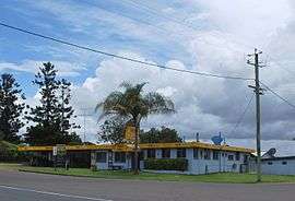 Harlin Hotel | |||||||||||||||
 Harlin | |||||||||||||||
| Coordinates | 26.9730°S 152.3566°E | ||||||||||||||
| Population | 173 (2016 census)[1] | ||||||||||||||
| • Density | 0.6766/km2 (1.752/sq mi) | ||||||||||||||
| Postcode(s) | 4314 | ||||||||||||||
| Area | 255.7 km2 (98.7 sq mi) | ||||||||||||||
| Time zone | AEST (UTC+10:00) | ||||||||||||||
| Location | |||||||||||||||
| LGA(s) | Somerset Region | ||||||||||||||
| County | Cavendish | ||||||||||||||
| Parish | Colinton | ||||||||||||||
| State electorate(s) | Nanango | ||||||||||||||
| Federal Division(s) | Blair | ||||||||||||||
| |||||||||||||||
Geography
Harlin is a small town in South East Queensland. The town is on the Brisbane Valley Highway and the Brisbane River, 131 kilometres (81 mi) north west of the state capital, Brisbane.
History
The town was named after Charlotte (née Harlin), wife of John Dunn Moore of the Colinton pastoral property. Their son William John Harlin Moore was a Member of the Queensland Legislative Assembly.[2]
Harlin Post Office opened by September 1907 (a receiving office had been open from 1905) and closed in 1989.[4]
Harlin Provisional School opened on 1908. On 1 January 1909 it became Harlin State School.[5][6]
The town was marooned during the 2011 Floods. Over 40 travellers were stranded by the dangerous and rising flood waters of the Brisbane River and the Ivory and Maronghi Creeks. They were housed by the publicans and owners of the Harlin Hotel and the Caltex service station from 9 January 2011, until the flooded creeks and rivers subsided.
At the 2011 census, Harlin and the surrounding area had a population of 534.[7]
Heritage listings
Harlin has a number of heritage-listed sites, including:
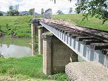
- over Ivory (formerly Maronghi) Creek: Harlin Rail Bridge[8]
- Sinnamons Lane: Yimbun Railway Tunnel[9]
Education
Harlin State School is a government primary (Prep-6) school for boys and girls at Brisbane Valley Highway (26.9740°S 152.3574°E).[10][11] In 2017, the school had an enrolment of 65 students with 5 teachers (4 full-time equivalent) and 5 non-teaching staff (3 full-time equivalent).[12]
References
- Australian Bureau of Statistics (27 June 2017). "Harlin (SSC)". 2016 Census QuickStats. Retrieved 20 October 2018.

- "Harlin - town in Somerset Region (entry 15402)". Queensland Place Names. Queensland Government. Retrieved 17 November 2019.
- "Harlin - locality in Somerset Region (entry 50296)". Queensland Place Names. Queensland Government. Retrieved 17 November 2019.
- Premier Postal History. "Post Office List". Premier Postal Auctions. Retrieved 10 May 2014.
- Queensland Family History Society (2010), Queensland schools past and present (Version 1.01 ed.), Queensland Family History Society, ISBN 978-1-921171-26-0
- "Opening and closing dates of Queensland Schools". Queensland Government. Retrieved 18 April 2019.
- Australian Bureau of Statistics (31 October 2012). "Harlin (State Suburb)". 2011 Census QuickStats. Retrieved 15 May 2015.
- "Harlin Rail Bridge (entry 602636)". Queensland Heritage Register. Queensland Heritage Council. Retrieved 12 July 2013.
- "Yimbun Railway Tunnel (entry 602637)". Queensland Heritage Register. Queensland Heritage Council. Retrieved 12 July 2013.
- "State and non-state school details". Queensland Government. 9 July 2018. Archived from the original on 21 November 2018. Retrieved 21 November 2018.
- "Harlin State School". Retrieved 21 November 2018.
- "ACARA School Profile 2017". Archived from the original on 22 November 2018. Retrieved 22 November 2018.