Hazeldean, Queensland
Hazeldean is a rural locality in the Somerset Region, Queensland, Australia.[2] In the 2016 census, Hazeldean had a population of 262 people.[1]
| Hazeldean Queensland | |||||||||||||||
|---|---|---|---|---|---|---|---|---|---|---|---|---|---|---|---|
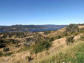 D'Aguilar Range and Somerset Dam along Esk Kilcoy Road, 2015 | |||||||||||||||
 Hazeldean | |||||||||||||||
| Coordinates | 27.0236°S 152.5463°E | ||||||||||||||
| Population | 262 (2016 census)[1] | ||||||||||||||
| • Density | 3.018/km2 (7.818/sq mi) | ||||||||||||||
| Postcode(s) | 4515 | ||||||||||||||
| Area | 86.8 km2 (33.5 sq mi) | ||||||||||||||
| Time zone | AEST (UTC+10:00) | ||||||||||||||
| LGA(s) | Somerset Region | ||||||||||||||
| State electorate(s) | Nanango | ||||||||||||||
| Federal Division(s) | Blair | ||||||||||||||
| |||||||||||||||
Geography
Lake Somerset coccupies the east of the locality. Lake Somerset is the reservoir created by the Somerset Dam impounding the Stanley River.[3][4]
The western part of the locality is elevated and remains mostly vegetated. The strip of land between the lake and the mountains is mostly rural-residential.[3]
The Deer Reserve National Park (27.0811°S 152.526°E) is in the south-west of the locality and includes Mount Brisbane (27.0886°S 152.5272°E) in the south-western corner of the locality which is 684 metres (2,244 ft) above sea level.[3][5][6] The national park is 3,228 hectares (7,980 acres) and extends into the neighbouring localities of Fulham to the west, Cooeeimbardi to the south-west and Somerset Dam (the locality) to the south.[3]
The Deer Reserve State Forest (27.0006°S 152.4947°E) is in the north-west of the locality and includes Mount Goonneringerringgi (26.9999°S 152.5215°E) at 495 metres (1,624 ft) and Mount McConnel (26.9956°S 152.5089°E) at 277 metres (909 ft).[7][8] The state forest is 2,894 hectares (7,150 acres) and extends into the neighbouring localities of Gregors Creek to the north-west and Fulham to the west.[3]
History
In the 1920s a 300 metre tramway was constructed in Hazeldean to move timber down a steep descent from mountain top to bottom.[9]
At the 2011 Australian Census the population of Hazeldean was 267.[10]
Education
Stanley River Environmental Education Centre is an Outdoor and Evironmental Education Centre at 3856 Esk-Kilcoy Road (27.0107°S 152.5526°E).[11][12]
There are no schools in Hazeldean. The nearest primary and seconary schools are in Kilcoy.[13]
Attractions
Lake Somerset Holiday Park is a large park on the edge of Somerset Dam which offers a range of accommodation including cabins and camping.
See also
References
- Australian Bureau of Statistics (27 June 2017). "Hazeldean (SSC)". 2016 Census QuickStats. Retrieved 20 October 2018.

- "Hazeldean - locality in Somerset Region (entry 48227)". Queensland Place Names. Queensland Government. Retrieved 17 November 2019.
- "Queensland Globe". State of Queensland. Retrieved 3 July 2020.
- "Lake Somerset - reservoir in the Somerset Region (entry 31392)". Queensland Place Names. Queensland Government. Retrieved 3 July 2020.
- "Deer Reserve National Park - National park in the Somerset Region (entry 44059)". Queensland Place Names. Queensland Government. Retrieved 3 July 2020.
- "Mount Brisbane - mountain in the Somerset Region (entry 4564)". Queensland Place Names. Queensland Government. Retrieved 3 July 2020.
- "Mount Goonneringerringgi - mountain in the Somerset Region (entry 14309)". Queensland Place Names. Queensland Government. Retrieved 3 July 2020.
- "Mount McConnel - mountain in the Somerset Region (entry 21317)". Queensland Place Names. Queensland Government. Retrieved 3 July 2020.
- Kerr and Philpott, JD and MM (1971). "Lars Andersen's Timber Tramways" (PDF). southburnett.biz. Queensland Heritage. Retrieved 29 December 2019.
- Australian Bureau of Statistics (31 October 2012). "Hazeldean (State Suburb)". 2011 Census QuickStats. Retrieved 21 August 2015.
- "State and non-state school details". Queensland Government. 9 July 2018. Archived from the original on 21 November 2018. Retrieved 21 November 2018.
- "Stanley River Environmental Education Centre". Retrieved 21 November 2018.
- "Queensland Globe". State of Queensland. Retrieved 17 November 2019.
External links
![]()