Bryden, Queensland
Bryden is a small rural locality in the Somerset Region, Queensland, Australia.[1]
| Bryden Queensland | |||||||||||||||
|---|---|---|---|---|---|---|---|---|---|---|---|---|---|---|---|
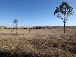 Paddocks along Corcorans Road, 2015 | |||||||||||||||
 Bryden | |||||||||||||||
| Coordinates | 27.2099°S 152.5906°E | ||||||||||||||
| Postcode(s) | 4312 | ||||||||||||||
| LGA(s) | Somerset Region | ||||||||||||||
| State electorate(s) | Nanango | ||||||||||||||
| Federal Division(s) | Blair | ||||||||||||||
| |||||||||||||||
The east of Bryden contains undeveloped bushland on the western slopes of the D'Aguilar Range.
History
The name Bryden comes from the name of the first settler in the area. The area was originally named Deep Creek.[1]
At the 2011 census Bryden was included in the population statistics for a wider area including Crossdale, which recorded a population of 190.[2]
Heritage listings
Bryden has a number of heritage-listed sites, including Castleholme Homestead along Bryden-Crossdale Road.[3]
Facilities
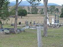
Bryden cemetery
There is a Catholic cemetery in Bryden at 27.2433°S 152.5703°E adjacent to Castleholme Homestead.[3]
gollark: It has a dedicated GLEU5-616 reactor.
gollark: There's also a factory for potatOS computers made in partnership with Microsoft.
gollark: Well, I mean, mostly just the top two.
gollark: No, most of the floors are mostly empty.
gollark: * mostly empty
References
- "Bryden (entry 44847)". Queensland Place Names. Queensland Government. Retrieved 12 July 2013.
- Australian Bureau of Statistics (31 October 2012). "Bryden (Gazetted Locality)". 2011 Census QuickStats. Retrieved 21 August 2015.

- "Castleholme Homestead (entry 600491)". Queensland Heritage Register. Queensland Heritage Council. Retrieved 12 July 2013.
This article is issued from Wikipedia. The text is licensed under Creative Commons - Attribution - Sharealike. Additional terms may apply for the media files.