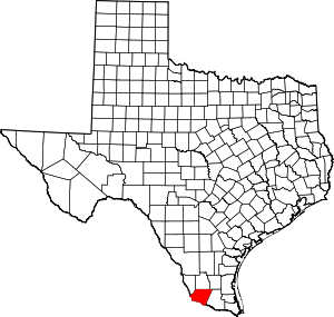
El Chaparral, Texas
El Chaparral is a census-designated place (CDP) in Starr County, Texas, United States. It is a new CDP for 2010 census with a population of 464. It was formed along with Santa Rosa CDP from the old Santa Cruz CDP. (Not to confused with the new Santa Cruz CDP.)[1]
El Chaparral, Texas | |
|---|---|
| Coordinates: 26°20′56″N 98°46′2″W | |
| Country | United States |
| State | Texas |
| County | Starr |
| Area | |
| • Total | 0.1 sq mi (0.3 km2) |
| • Land | 0.1 sq mi (0.3 km2) |
| • Water | 0.0 sq mi (0 km2) |
| Population (2010) | |
| • Total | 464 |
| • Density | 4,600/sq mi (1,800/km2) |
| Time zone | UTC-6 (Central (CST)) |
| • Summer (DST) | UTC-5 (CDT) |
| Zip Code | 78582 |
Geography
El Chaparral is located at 26°20′56″N 98°46′2″W (26.348795, -98.767339).[2]
gollark: Wait, so you're against monopolies but for authoritarian governments?
gollark: Probably money, if there's some sort of ridiculous conspiracy to make North Korea look bad.
gollark: I am *not*, since going around punishing for speech (except in rare cases of direct harm) is a very problematic and slippery slope.
gollark: If you give governments or whoever the power to go around getting rid of speech *you* don't like, they can happily proceed to do it to speech you like too.
gollark: If you can consider "saying the government is bad" harm you can consider "talking about some religion/participating in it" harm.
References
- "Population and Housing Unit Counts, 2010 Census of Population and Housing" (PDF). Texas: 2010.
- "El Chaparral, Texas :: Boundary Map of El Chaparral, Texas". Archived from the original on 2016-12-21. Retrieved 2016-12-20.
This article is issued from Wikipedia. The text is licensed under Creative Commons - Attribution - Sharealike. Additional terms may apply for the media files.
