Mi Ranchito Estate, Texas
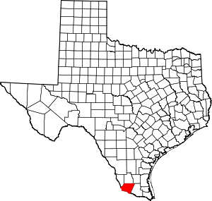
Mi Ranchito Estate is a census-designated place (CDP) in Starr County, Texas, United States. It is a new CDP for the 2010 census with a population of 281. Parts of this new CDP were formed from the former Los Villareales CDP.[1]
Mi Ranchito Estate, Texas | |
|---|---|
| Coordinates: 26°23′16″N 98°52′24″W | |
| Country | United States |
| State | Texas |
| County | Starr |
| Area | |
| • Total | 0.3 sq mi (0.8 km2) |
| • Land | 0.3 sq mi (0.8 km2) |
| • Water | 0.0 sq mi (0 km2) |
| Population (2010) | |
| • Total | 281 |
| • Density | 940/sq mi (360/km2) |
| Time zone | UTC-6 (Central (CST)) |
| • Summer (DST) | UTC-5 (CDT) |
| Zip Code | 78582 |
Geography
Mi Ranchito Estate is located at 26°23′16″N 98°52′24″W (26.387810, -98.873329).[2]
gollark: The kindle I have seems to run (some form of) Linux, on which everything runs as root.
gollark: I have one of the actual e-ink kindles. They're quite cool, though horribly insecure.
gollark: Base 3 forever!
gollark: Get waterproof paper or something.
gollark: Ah, licensing. Basically half the reason why I prefer FOSS stuff...
References
This article is issued from Wikipedia. The text is licensed under Creative Commons - Attribution - Sharealike. Additional terms may apply for the media files.
