El Mesquite, Texas
El Mesquite is a census-designated place (CDP) in Starr County, Texas, United States. This was a new CDP for the 2010 census with a population of 38.[1]
El Mesquite, Texas | |
|---|---|
| Coordinates: 26°23′5″N 98°46′18″W | |
| Country | United States |
| State | Texas |
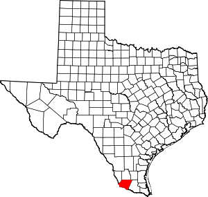
| County | Starr |
| Population (2010) | |
| • Total | 38 |
| Time zone | UTC-6 (Central (CST)) |
| • Summer (DST) | UTC-5 (CDT) |
| Zip Code | 78582 |
Geography
El Mesquite is located at 26°23′5″N 98°46′18″W (26.384685, -98.771579).[2]
gollark: You can't crash them, but they can be stopped easily.
gollark: Atomik: Ale's, my and Terra's base are connected. I am considering laser turrets on the Terra side.
gollark: Lemons are illegal.
gollark: Potatos
gollark: I ç.
References
- "Population and Housing Unit Counts, 2010 Census of Population and Housing" (PDF). Texas: 2010.
- "El Mesquite, Texas :: Boundary Map of El Mesquite, Texas". Archived from the original on 2016-12-28. Retrieved 2016-12-28.
This article is issued from Wikipedia. The text is licensed under Creative Commons - Attribution - Sharealike. Additional terms may apply for the media files.