Eaux Claires, Edmonton
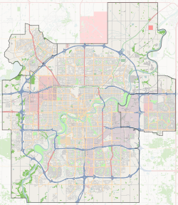
Eaux Claires is a residential neighbourhood located in north east Edmonton, Alberta, Canada. It is bounded on the north by 167 Avenue, on the west by 97 Street, and on the south by 153 Avenue. The east boundary runs along a line located between 89 Street and 90 Street. Travel north along 97 Street takes residents to CFB Edmonton while travel south along 97 Street takes residents past the Northern Alberta Institute of Technology and into the downtown core.
Eaux Claires | |
|---|---|
Neighbourhood | |
 Eaux Claires Location of Eaux Claires in Edmonton | |
| Coordinates: 53.620°N 113.487°W | |
| Country | |
| Province | |
| City | Edmonton |
| Quadrant[1] | NW |
| Ward[1] | 3 |
| Sector[2] | North |
| Area[3][4] | Lake District |
| Government | |
| • Administrative body | Edmonton City Council |
| • Councillor | Dave Loken |
| Area | |
| • Total | 1.28 km2 (0.49 sq mi) |
| Elevation | 681 m (2,234 ft) |
| Population (2012)[7]nbhds | |
| • Total | 3,235 |
| • Density | 2,527.3/km2 (6,546/sq mi) |
| • Change (2009–12) | |
| • Dwellings | 1,168 |
Housing in the neighbourhood is a mixture of single-family houses (55.7%), walk-up apartment style condominiums (32.6%), and duplexes[8] (11.7%). The majority of residential dwelling units are owner-occupied.[9]
Demographics
In the City of Edmonton's 2012 municipal census, Eaux Claires had a population of 3,235 living in 1,168 dwellings,[7] a 14.4% change from its 2009 population of 2,828.[10] With a land area of 1.28 km2 (0.49 sq mi),[6] it had a population density of 2,527.3 people/km2 in 2012.[7][6]
Eaux Claires Transit Centre
Eaux Claires Transit Centre | |
|---|---|
 | |
| Platforms | 17 bus bays[11] |
| Construction | |
| Parking | Yes |
| Bicycle facilities | Yes |
| Disabled access | Yes |
| Other information | |
| Website | Eaux Claires Transit Centre |
| History | |
| Opened | August 26, 2011[12] |
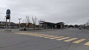
The Eaux Claires Transit Centre is situated along 97 street at 157 avenue. It has several amenities including bike racks, park and ride (300 spaces), a drop off area, vending machines and washrooms.[13][12]
The transit centre opened on August 26, 2011 with a construction cost of $12 million, in which $4 million was provided by both the provincial and federal governments.[12]
The following bus routes serve the transit centre:[14]
| To/From | Routes |
|---|---|
| Abbottsfield Transit Centre | 180 |
| Archbishop O'Leary | 145, 167 |
| Belle Rive | 191 |
| Belvedere Transit Centre | 180 |
| Bonnie Doon | 15 |
| Carlton | 168 |
| Castle Downs Transit Centre | 16, 162 |
| Century Park Transit Centre | 9 |
| Chambery | 163 |
| Clareview Transit Centre | 149, 187, 188, 190 |
| Cumberland | 168 |
| Downtown | 9, 15, 16, 162 |
| Government Centre Transit Centre | 16, 162 |
| Jasper Place Transit Centre | 150 |
| Kernohan | 187, 188 |
| Kingsway/Royal Alex Transit Centre | 9 |
| Klarvatten | 191 |
| Lago Lindo | 145 |
| Lake District | 149 |
| Lakewood Transit Centre | 15 |
| Londonderry | 187, 188, 190 |
| MacEwan | 15, 162 |
| Millgate Transit Centre | 15 |
| Mill Woods Transit Centre | 15 |
| NAIT | 9, 15 |
| Northgate Transit Centre | 9, 15, 16, 150, 168 |
| Ozerna | 190 |
| Pilot Sound | 149 |
| Queen Elizabeth | 167 |
| Schonsee | 194 |
| Southgate Transit Centre | 9 |
| West Edmonton Mall Transit Centre | 150 |
| Westmount Transit Centre | 150 |
School special routes that arrive/depart from Eaux Claires Transit Centre include routes: 9S, 16S, 140S, 145S, 163S, 167S, 805, and 806.[15]
Surrounding neighbourhoods
Surrounding residential neighbourhoods are: Baturyn, Beaumaris, Belle Rive, Evansdale, Griesbach, Klarvatten, Lago Lindo, and Lorelei.
See also
- Edmonton Transit System
References
- "City of Edmonton Wards & Standard Neighbourhoods" (PDF). City of Edmonton. Archived from the original (PDF) on May 3, 2014. Retrieved February 13, 2013.
- "Edmonton Developing and Planned Neighbourhoods, 2011" (PDF). City of Edmonton. Archived from the original (PDF) on September 4, 2013. Retrieved February 13, 2013.
- "The Way We Grow: Municipal Development Plan Bylaw 15100" (PDF). City of Edmonton. 2010-05-26. Archived from the original (PDF) on May 2, 2015. Retrieved February 13, 2013.
- "City of Edmonton Plans in Effect" (PDF). City of Edmonton. November 2011. Archived from the original (PDF) on October 17, 2013. Retrieved February 13, 2013.
- "City Councillors". City of Edmonton. Retrieved February 13, 2013.
- "Neighbourhoods (data plus kml file)". City of Edmonton. Retrieved February 13, 2013.
- "Municipal Census Results – Edmonton 2012 Census". City of Edmonton. Retrieved February 22, 2013.
- Includes triplexes and quadruplexes.
- and
- "2009 Municipal Census Results". City of Edmonton. Retrieved February 22, 2013.
- "Eaux Claires Transit Centre Map" (PDF). City of Edmonton. Retrieved 1 July 2018.
- "Governments Celebrate Completion of Eaux Claires Transit Centre". Government of Canada. 26 August 2011. Retrieved 16 March 2018.
- "Eaux Claires Transit Centre". City of Edmonton. Retrieved September 28, 2017.
- "Brochures in PDF". City of Edmonton. Retrieved 1 September 2019.
- "School Service: ETS Trip Planner". City of Edmonton. Retrieved 28 August 2019.
External links
| Wikimedia Commons has media related to Eaux Claires Transit Centre. |