County of Polwarth
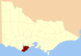
The County of Polwarth is one of the 37 counties of Victoria which are part of the cadastral divisions of Australia, used for land titles. The county is in the Western District of Victoria and includes the Cape Otway area, bounded by the Gellibrand River in the west and the Anglesea River and Barwon River in the east, in the north by a line from Winchelsea, through Colac to Larpent, and by Bass Strait to the south. The largest town is Colac. The county was proclaimed in 1849.
| Polwarth Victoria | |||||||||||||||
|---|---|---|---|---|---|---|---|---|---|---|---|---|---|---|---|
 Location in Victoria | |||||||||||||||
| |||||||||||||||
Parishes
Parishes within the county:
- Aire
- Angahook
- Bambra
- Barongarook
- Barramunga
- Barwon Downs
- Barwongemoong
- Birregurra (part in the County of Grenville)
- Boonah
- Colac
- Elliminyt
- Gerangamete
- Irrewarra
- Irrewillipe
- Kaanglang
- Krambruk
- La Trobe (part in the County of Heytesbury)
- Lorne
- Moomowroong
- Moorbanool
- Murroon
- Nalangil
- Natte Murrang
- Newlingrook
- Olangolah
- Otway
- Pirron Yaloak
- Wangerrip
- Warrion (part in the County of Grenville)
- Weeaproinah
- Wensleydale
- Whoorel
- Wongarra
- Wyelangta
- Yan Yan Gourt
- Yaugher
- Yeo
gollark: Er, yes, although I have no idea who you are.
gollark: He left AGES ago.
gollark: You don't need to go as far as wireshark or something, just shove together a simple program which listens on a port and prints things.
gollark: What stops someone from just listening to the port your thing transmits on and ignoring the bit saying who should receive the packets?
gollark: It's very unpleasant. I used it a bit
References
- Rootsweb Genealogy, Victorian Counties, retrieved 20 September 2008
External links
This article is issued from Wikipedia. The text is licensed under Creative Commons - Attribution - Sharealike. Additional terms may apply for the media files.