County of Dalhousie, Victoria
The County of Dalhousie is one of the 37 counties of Victoria which are part of the cadastral divisions of Australia, used for land titles. It is located to the north of Melbourne. It is bounded by the Coliban River to the west. The Goulburn River forms part of the boundary to the north-east. Puckapunyal is on its northern edge, and Kilmore and Woodend on its southern edge. The county was proclaimed in 1849.
| Dalhousie Victoria | |||||||||||||||
|---|---|---|---|---|---|---|---|---|---|---|---|---|---|---|---|
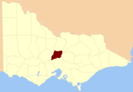 Location in Victoria | |||||||||||||||
| |||||||||||||||
Parishes
Parishes include:
- Baynton, Victoria
- Broadford, Victoria
- Bylands, Victoria
- Cobaw, Victoria
- Edgecombe, Victoria
- Emberton, Victoria
- Glenaroua, Victoria
- Glenburnie, Victoria
- Glenhope, Victoria
- Heathcote, Victoria
- Lancefield, Victoria
- Langley, Victoria
- Lauriston, Victoria
- Metcalfe, Victoria
- Mitchell, Victoria
- Moranding, Victoria
- Newham, Victoria
- Northwood, Victoria
- Panyule, Victoria
- Puckapunyal, Victoria
- Pyalong, Victoria
- Redesdale, Victoria
- Springplains, Victoria
- Trentham, Victoria
- Tylden, Victoria
- Woodend, Victoria
gollark: There's only one authority for d.osmarks.net and it's my server.
gollark: People want to be able to know the IPs for things still, I guess.
gollark: Generally you won't talk to my nameserver directly but to a recursive DNS resolver which then looks it up. The nice thing about DNS is that even on internal network-type things, DNS queries will quite likely be propagated to the outside world.
gollark: That nameserver parses the DNS query and does stuff based on its contents.
gollark: If something wants to get records for a subdomain, they talk to my nameserver.
References
- Vicnames, place name details
- Cadastral map of the county of Dalhousie in Victoria showing parish and county boundaries and topographical information., 1866, National Library of Australia
This article is issued from Wikipedia. The text is licensed under Creative Commons - Attribution - Sharealike. Additional terms may apply for the media files.