County of Tatchera
The County of Tatchera is one of the 37 counties of Victoria which are part of the cadastral divisions of Australia, used for land titles. It is located to the south of the Murray River, and to the south west of Swan Hill, with its western boundary at 143°E, and part of the southern boundary at 36°S.
| Tatchera Victoria | |||||||||||||||
|---|---|---|---|---|---|---|---|---|---|---|---|---|---|---|---|
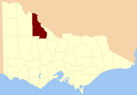 Location in Victoria | |||||||||||||||
| |||||||||||||||
Parishes
Parishes include:
- Bael Bael, Victoria
- Benjeroop, Victoria
- Berriwillock, Victoria
- Boga, Victoria
- Boort, Victoria
- Budgerum East, Victoria
- Budgerum West, Victoria
- Burra, Victoria
- Cannie, Victoria
- Carapugna, Victoria
- Castle Donnington, Victoria
- Chillingollah, Victoria
- Chinangin, Victoria
- Coonimur, Victoria
- Cooroopajerrup, Victoria
- Dartagook, Victoria
- Gnarwee, Victoria
- Gredgwin, Victoria
- Jeruk, Victoria
- Kalpienung, Victoria
- Kaneira, Victoria
- Kooem, Victoria
- Koorangie, Victoria
- Koorkahb, Victoria
- Koro-Ganeit, Victoria
- Korrak Korrak, Victoria
- Kunat Kunat, Victoria
- Lalbert, Victoria
- Leaghur, Victoria
- Marmal, Victoria
- Meatian, Victoria
- Meering, Victoria
- Meering West, Victoria
- Meran, Victoria
- Mirkoo, Victoria
- Mumbel, Victoria
- Murnungin, Victoria
- Narrung, Victoria
- Ninveunook, Victoria
- Nowie, Victoria
- Nullawil, Victoria
- Nyrraby, Victoria
- Pental Island, Victoria
- Perrit Perrit, Victoria
- Piangil, Victoria
- Piangil West, Victoria
- Pines, Victoria
- Polisbet, Victoria
- Quambatook, Victoria
- Talgitcha, Victoria
- Tittybong, Victoria
- Toort, Victoria
- Towan, Victoria
- Towaninny, Victoria
- Turoar, Victoria
- Tyntynder, Victoria
- Tyntynder North, Victoria
- Tyntynder West, Victoria
- Ultima, Victoria
- Waitchie, Victoria
- Wakool, Victoria
- Wandown, Victoria
- Wangie, Victoria
- Wewin, Victoria
- Woorinen, Victoria
- Yungiera, Victoria
gollark: People could use it to discuss currently playing tracks and such.
gollark: What if APIONET frontend for #o on the osmarks internet radio™ page?
gollark: Oh bee oh apiary form.
gollark: Oh, and how English secretly has strictish adjective ordering.
gollark: It's also been shown that if I say the the word "the" twice, you're unlikely to notice. Mostly in longer paragraphs, but it might work here too.
References
- Vicnames, place name details
- Research aids, Victoria 1910
- County of Tatchera, Cadastral map showing county and parish boundaries, categories of lands holdings and reserves., 1880s. National Library of Australia
This article is issued from Wikipedia. The text is licensed under Creative Commons - Attribution - Sharealike. Additional terms may apply for the media files.