Bass Strait
Bass Strait (/bæs/) is a sea strait separating Tasmania from the Australian mainland, specifically the state of Victoria.
| Bass Strait | |
|---|---|
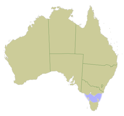 Map of Australia with Bass Strait marked in light blue | |
| Location | Indian Ocean–Pacific Ocean |
| Coordinates | 40°S 146°E |
| Type | Strait |
| Basin countries | Australia |
| Max. length | 500 kilometres (310 mi) |
| Max. width | 350 kilometres (220 mi) |
| Average depth | 60 metres (200 ft) |
| Max. depth | 155 m (509 ft) |
Extent
The International Hydrographic Organization defines the limits of Bass Strait as follows:[1]
- On the west. The eastern limit of the Great Australian Bight [being a line from Cape Otway, Australia, to King Island and thence to Cape Grim, the northwest extreme of Tasmania].
- On the east. The western limit of the Tasman Sea between Gabo Island and Eddystone Point [being a line from Gabo Island (near Cape Howe, 37°30′S) to the northeast point of East Sister Island (148°E) thence along the 148th meridian to Flinders Island; beyond this Island a line running to the Eastward of the Vansittart Shoals to [Cape] Barren Island, and from Cape Barren (the easternmost point of [Cape] Barren Island) to Eddystone Point (41°S) [in Tasmania].

Differing views of location and context
Some authorities consider the strait to be part of the Pacific Ocean[2] as in the never-approved 2002 IHO Limits of Oceans and Seas draft. In the currently in-force IHO 1953 draft, it is instead listed as part of the Indian Ocean.[1]
The Australian Hydrographic Service does not consider it to be part of the Southern Ocean, using the expanded Australian definition, and states that it lies with the Tasman Sea.[3] The strait between the Furneaux Islands and Tasmania is Banks Strait, a subdivision of Bass Strait.
Discovery and exploration
By Aboriginals
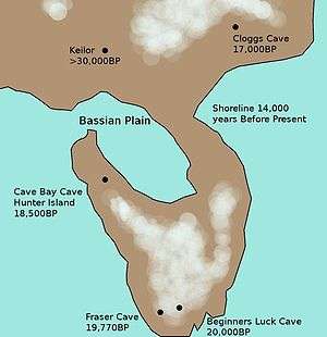
Aboriginal Tasmanians arrived in Tasmania approximately 40,000 years ago, across a land bridge called the Bassian Plain during the last glacial period.[4] Sea levels rose to form Bass Strait 8,000 years ago leaving them isolated from the rest of Australia. Aboriginal people lived on Flinders Island until around 4,000 years ago.
Based on the recorded language groups, there were at least three successive waves of aboriginal colonisation.
By Europeans
The strait was possibly detected by Captain Abel Tasman when he charted Tasmania's coast in 1642. On 5 December, Tasman was following the east coast northward to see how far it went. When the land veered to the north-west at Eddystone Point,[5] he tried to keep in with it but his ships were suddenly hit by the Roaring Forties howling through Bass Strait.[6] Tasman was on a mission to find the Southern Continent, not more islands, so he abruptly turned away to the east and continued his continent hunting.[7]
The next European to enter the strait was Captain James Cook in the Endeavour in April 1770. However, after sailing for two hours westward into the strait against the wind, he turned back east and noted in his journal that he was "doubtful whether they [i.e. Van Diemen's Land and New Holland] are one land or no",[8]
The strait was named after George Bass, after he and Matthew Flinders passed through it while circumnavigating Van Diemen's Land (now named Tasmania) in the Norfolk in 1798–99. At Flinders' recommendation, the Governor of New South Wales, John Hunter, in 1800 named the stretch of water between the mainland and Van Diemen's Land "Bass's Straits".[9] Later it became known as Bass Strait.
The existence of the strait had been suggested in 1797 by the master of Sydney Cove when he reached Sydney after deliberately grounding his foundering ship and being stranded on Preservation Island (at the eastern end of the strait). He reported that the strong south westerly swell and the tides and currents suggested that the island was in a channel linking the Pacific and southern Indian Ocean. Governor Hunter thus wrote to Joseph Banks in August 1797 that it seemed certain a strait existed.[10]
When news of the 1798 discovery of Bass Strait reached Europe, the French government despatched a reconnaissance expedition commanded by Nicolas Baudin. This prompted Governor King to send two vessels from Sydney to the island to establish a garrison at Hobart.[11]
Maritime history
Strong currents between the Antarctic-driven southeast portions of the Indian Ocean and the Tasman Sea's Pacific Ocean waters provide a strait of powerful, wild storm waves. The shipwrecks on the Tasmanian and Victorian coastlines number in the hundreds, although stronger metal ships and modern marine navigation have greatly reduced the danger.
Many vessels, some quite large, have disappeared without a trace, or left scant evidence of their passing. Despite myths and legends of piracy, wrecking and alleged supernatural phenomena akin to those of the Bermuda Triangle, such disappearances can be invariably ascribed to treacherous combinations of wind and sea conditions, and the numerous semi-submerged rocks and reefs within the Straits.[12]
Despite the strait's difficult waters, it provided a safer and less boisterous passage for ships on the route from Europe or India to Sydney in the early 19th century. The strait also saved 1,300 km (700 nmi) on the voyage.[10]
Geography

Bass Strait is approximately 250 km (160 mi) wide and 500 km (310 mi) long, with an average depth of 60 m (200 ft). The widest opening is about 350 km between Cape Portland on the North-Eastern tip of Tasmania and Point Hicks on the Australian mainland. Jennings'[13] study of the submarine topography of Bass Strait described the bathymetric Bass Basin, a shallow depression approximately 120 km (70 mi) wide and 400 km (250 mi) long (over 65,000 km2 [25,000 sq mi] in area) in the centre of Bass Strait, a maximum depth is the channel between Inner Sister and Flinders, which navigation charts indicate reaches 155 m (510 ft). Two plateaus, the Bassian Rise and King Island Rise located on the eastern and western margins of Bass Strait, respectively, are composed of a basement of Palaeozoic granite. These features form sills separating Bass Basin from the adjacent ocean basins. Associated with the less than 50 m (160 ft) deep Bassian Rise is the Furneaux Islands, the largest of which is Flinders Island (maximum elevation 760 m [2,490 ft]). The surface of the King Island Rise also occurs in water depths of less than 50 m (160 ft), and includes the shallow (40 m [130 ft]) Tail Bank at its northern margin as well as King Island itself. Subaqueous dunes (sandwaves) and tidal current ridges and subaqueous dunes cover approximately 6,000 km2 (2,300 sq mi) of the seabed in Bass Strait.[14]
During Pleistocene low sea level stands the central basin of Bass Strait was enclosed by raised sills forming a large shallow lake. This occurred during the last glacial maximum (18,000 BP) when the basin was completely isolated. Sea level rise during the marine transgression flooded the basin, forming a marine embayment from 11,800 BP to 8700 BP and the basin rim was completely flooded by about 8000 BP, at which point Bass Strait was formed and Tasmania became a separate island.[15]
Like the rest of the waters surrounding Tasmania, and particularly because of its limited depth, it is notoriously rough, with many ships lost there during the 19th century. A lighthouse was erected on Deal Island in 1848 to assist ships in the eastern part of the Straits, but there were no guides to the western entrance until the Cape Otway Lighthouse was first lit in 1848, followed by another at Cape Wickham at the northern end of King Island in 1861.
Islands
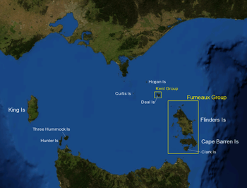
There are over 50 islands in Bass Strait. Major islands include:
Western section:
- King Island
- Three Hummock Island
- Hunter Island
- Robbins Island
South eastern section:
- Furneaux Group
- Flinders Island (where the surviving Aboriginal Tasmanians were exiled)
- Cape Barren Island
- Clarke Island
- Sister Islands Group
- and several other islands
North eastern section:
- Kent Group
- Deal Island
- and 3 smaller islands
- Hogan Island
- Curtis Island
Protected areas
Federal
Within Bass Strait there are several Commonwealth marine reserves, which are all part of the South-east Network. The two larger reserves, Flinders and Zeehan, extend mostly outside of the Bass Strait area.
State
The smaller islands of Bass Strait typically have some form of protection status. Most notably the Kent Group National Park covers the Kent Group islands of Tasmania, as well as the surrounding state waters which is a dedicated marine reserve. The national park is wholly contained by the Beagle Commonwealth Marine Reserve.
Victoria has several marine national parks in Bass Strait, and are all adjacent to the mainland coastline:
Natural resources
A number of oil and gas fields exist in the eastern portion of Bass Strait, in what is known as the Gippsland Basin. Most large fields were discovered in the 1960s, and are located about 50 to 65 km (30 to 40 mi) off the coast of Gippsland in water depths of about 70 m (230 ft).[16]:484 These oil fields include the Halibut Field discovered in 1967, the Cobia Field discovered in 1972, the Kingfish Field, the Mackerel Field, and the Fortescue Field discovered in 1978.[16]:484 Large gas fields include the Whiptail field, the Barracouta Field, the Snapper Field, and the Marlin Field.[16]:484 Oil and gas are produced from the Cretaceous-Eocene clastic rocks of the Latrobe Group, deposited with the break-up of Australia and Antarctica.[16]:485
The western field, known as the Otway Basin, was discovered in the 1990s offshore near Port Campbell. Its exploitation began in 2005.
The oil and gas is sent via pipeline to gas processing facilities and oil refineries at Longford, Western Port, Altona and Geelong, as well as by tanker to New South Wales. Pipelines from the Otway Basin gas fields lead to several processing facilities in the vicinity of Port Campbell.
In June 2017, the Government of Victoria announced a three-year feasibility study[17] for Australia's first offshore wind farm. The project, which could have 250 wind turbines within a 574 km2 (222 sq mi) area, is projected to deliver around 8,000 GWh of electricity, representing some 18 per cent of Victoria's power usage and replacing a large part of the output of Hazelwood Power Station, which was closed in early 2017.
Infrastructure
Transport
The fastest and often the cheapest method of travel across Bass Strait is by air. The major airports in Tasmania are Hobart International Airport and Launceston Airport, where the main airlines are Jetstar and Virgin Australia. Qantas also operates services. The smaller airports in the north of the state and on the islands in the strait are served either by Regional Express Airlines, QantasLink or King Island Airlines.
Ferries
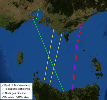
The domestic sea route is serviced by two Spirit of Tasmania passenger vehicle ferries, based in Devonport, Tasmania. The ships travel daily in opposite directions between Devonport and Station Pier in Melbourne, as overnight trips with additional daytime trips during the peak summer season.[18]
Energy
The Basslink HVDC electrical cable has been in service since 2006. It has the capacity to carry up to 630 megawatts of electrical power across the strait.
Alinta owns a submarine gas pipeline, delivering natural gas to large industrial customers near George Town, as well as the Powerco gas network in Tasmania.
Communications
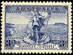
The first submarine communications cable across Bass Strait was laid in 1859. Starting at Cape Otway, Victoria, it went via King Island and Three Hummock Island, made contact with the Tasmanian mainland at Stanley Head, and then continued on to George Town. However it started failing within a few weeks of completion, and by 1861 it failed completely.
Tasmania is currently connected to the mainland via two Telstra-operated fibre optic cables; since 2006, dark fibre capacity has also been available on the Basslink HVDC cable.
Other submarine cables include:
| Date | Northern end | Southern end | Companies (Manufacturer / Operator) |
Details |
|---|---|---|---|---|
| 1859–1861 | Cape Otway | Stanley Head | Henley's Telegraph Works Tas & Vic Govts |
System 260 km (140 nmi) |
| 1869-? | ? | ? | Henley's Telegraph Works Australian Govt |
System 326 km (176 nmi) |
| 1885-? | ? | ? | Telcon Australian Government |
|
| 1909–1943 | ? | ? | Siemens Brothers Australian Government |
System 528 km (285 nmi) Was reused at Torres Strait |
| 1936 | Apollo Bay | Stanley | Siemens Brothers Australian Government |
First telephone cable, failed after only six months[19] |
| 1995- | Sandy Point | Boat Harbour | ASN Telstra |
First fibre optic cable |
| 2003- | Inverloch | Stanley | ASN Calais Telstra |
|
| 2005- | Loy Yang | Bell Bay | Basslink | First electrical transmission cable |
Popular culture
In 1978, one of the most famous UFO incidents in Australian history occurred over Bass Strait. Frederick Valentich was flying a small aeroplane over the strait when he reported to personnel at a local airport that a strange object was buzzing his plane. He then claimed that the object had moved directly in front of his plane; the airport personnel then heard a metallic "scraping" sound, followed by silence. Valentich and his plane subsequently vanished and neither Valentich nor his plane were ever seen again.
The issue of planes, ships and people having been lost in the strait over time has spawned a number of theories. Perhaps the most thorough list of losses and disappearances has been the oft reprinted book of Jack Loney[20] though it is possible that most losses can be adequately explained by extreme weather events.[21]
On the popular Australian soap Neighbours, one of its most dramatic storylines unfolded when a 1940s themed joy flight to Tasmania was sabotaged by a bomb. The plane crashed into Bass Strait in the middle of the night and many character's lives were put at risk, with some drowning.
Non-motorised crossings
Bass Strait is regularly crossed by sailing vessels, including during the annual Melbourne to Hobart Yacht Race. The Sydney to Hobart Yacht Race passes generally east of the strait but is affected by its weather conditions.
Australian Olympic bronze medalist Michael Blackburn set a record in March 2005 when he crossed the strait in just over 13 hours in a Laser sailing dinghy.[22]
Lone rower David Bowen from Mount Martha crossed Bass Strait in 1971 rowing a 6.1 m (20 ft) dory, leaving from Devonport he landed on Wilson's Promontory.[23] Tammy van Wisse swam part of the strait in 1996, from King Island to Apollo Bay in Victoria, a distance of about 100 km (60 mi) in 17 hours and 46 minutes.[24][25] Rod Harris, Ian and Peter Richards are credited with the first kayak crossing in 1971. Many sea kayakers have since made the crossing, usually by island hopping on the eastern side of the strait.[26][27][28] Fewer sea kayak crossings have been made via King Island, due to the 100 km (60 mi) leg between Cape Wickam and Apollo Bay. Andrew McAuley was the first person to cross Bass Strait non-stop in a sea kayak in 2003. He made two more crossings of Bass Strait before he died attempting to cross the Tasman Sea in February 2007.[29] The first windsurfer crossing was in 1982 by Mark Paul and Les Tokolyi.[30] Kitesurfers have also completed the crossing.[31][32] The first crossing by paddleboard was made by Jack Bark, Brad Gaul and Zeb Walsh, leaving Wilsons Promontory in Victoria on 25 February 2014 and arriving at Cape Portland in northeastern Tasmania on 4 March 2014.[33]
In March 2009 two young dinghy sailors sailed a B14 high performance skiff from Stanley in north west Tasmania to Walkerville South in Victoria. The purpose of the voyage was to raise funds for the treatment of the endangered Tasmanian Devil, an animal species suffering from a facial tumour disease and, if possible, break the dinghy sailing time record for the crossing. The sailors Adrian Beswick and Josh Philips accompanied by a support vessel successfully completed the crossing in 14 hours 53 minutes.[34][35]
See also
- South-east Commonwealth Marine Reserve Network
References
- "Limits of Oceans and Seas, 3rd edition" (PDF). International Hydrographic Organization. 1953. Archived from the original (PDF) on 8 October 2011. Retrieved 7 February 2010.
- "Marine Gazetteer Placedetails". VLIZ. Archived from the original on 19 March 2016. Retrieved 29 May 2013.
- "AHS – AA609582" (PDF). The Australian Hydrographic Service. 5 July 2012. Retrieved 29 May 2013.
- Lourandos, Harry (March 1993). "Hunter-Gatherer Cultural Dynamics: Long- and Short-Term Trends in Australian Prehistory". Journal of Archaeological Research. 1 (1): 67–88. doi:10.1007/bf01327162. JSTOR 41053069.CS1 maint: ref=harv (link)
- Schilder, Günter (1976). Australia unveiled : the share of the Dutch navigators in the discovery of Australia. Amsterdam: Theatrum Orbis Terrarum Ltd. p. 170. ISBN 9022199975.
- Valentyn, Francois (1724–1726). Oud en nieuw Oost-Indien. Dordrecht: J. van Braam. p. vol.3, p.47. ISBN 9789051942347.CS1 maint: date format (link)
- Cameron-Ash, M. (2018). Lying for the Admiralty: Captain Cook's Endeavour Voyage. Sydney: Rosenberg. p. 105. ISBN 978-0-64804-396-6.
- Beaglehole, J. C. (ed) (1955). The Journals of Captain James Cook on his Voyage of Discovery, vol 1, the Voyage of the Endeavour, 1768-1771. Cambridge University Press, London. pp. 298–99 (18, 19 April 1770).CS1 maint: extra text: authors list (link)
- Flinders, Matthew (1814). A Voyage to Terra Australis
- Blainey, Geoffrey (1966). Tyranny of Distance: How Distance Shaped Australia's History. Melbourne: Sun Books. pp. 73–4.
- Cameron-Ash, M. (2018). Lying for the Admiralty. Sydney: Rosenberg. pp. 155–162. ISBN 9780648043966.
- See section below Popular Culture and also Bass Strait Triangle for further detail
- Jennings, J. N. (1958). The submarine topography of Bass Strait. Proceedings of the Royal Society of Victoria, 71, 49-71.
- Malikides, M., Harris, P. T., Jenkins, C. J., & Keene, J. B. (1988). Carbonate sandwaves in Bass Strait. Australian Journal of Earth Science, 35, 303-311
- Blom, W. M., & Alsop, D. B. (1988). Carbonate mud sedimentation on a temperate shelf: Bass Basin, southeast Australia. Sedimentary Geology, 60, 269-280
- Hendrich, J.H., Palmer, I.D., and Schwebel, D.A., 1992, Fortescue Field, Gippsland Basin, Offshore Australia, In Giant Oil and Gas Fields of the Decade, 1978-1988, AAPG Memoir 54, Halbouty, M.T., editor, Tulsa: American Association of Petroleum Geologists, ISBN 0891813330
- Peter Plowman (2004) Ferry to Tasmania: A short history Dural, N.S.W. : Rosenberg Publishing. ISBN 1-877058-27-0
- "Apollo Bay Submarine Cable Repeater Station". Register of the National Estate. aussieheritage.com.au. Archived from the original on 12 August 2008. Retrieved 13 August 2008.
- Jack Loney, Mysteries of the Bass Strait Triangle, Neptune Press, 1st ed. 1980. 3rd ed. 1984 5th ed. 1993 (ISBN 0-909131-53-8) and later editions,
- Spirit of Tasmania I section regarding 2005 event as a good example
- "Blackburn's Bass Strait Laser Sailing Record". Laser Sailing Tips. Retrieved 12 April 2017.
- Lone Rower Safe Ashore By Patrick Boyce "The Age" 22 March 1971.
- Helen Kempton (2 September 2009). "Pair to 'fly' across Bass Strait". The Mercury.
- "Bass Strait". Tammy van Wisse. Retrieved 1 June 2013.
- Break Loose Bass Strait Crossing by sea kayak. Retrieved from Internet Archive 27 December 2013.
- "Bass Strait Crossing". Paddle with Sim. Archived from the original on 21 March 2012. Retrieved 11 June 2012.
- Archived 4 May 2006 at the Wayback Machine
- "Andrew McAuley was not crazy or reckless but crossing the Tasman Sea in a kayak was a calculated, planned gamble he lost". The Age. Melbourne. 16 February 2007.
- The Sun 5 May 1982
- "Australian kitesurfers cross the Bass Strait for the first time". Surfertoday.com. 10 September 2009. Retrieved 11 June 2012.
- "Natalie Clarke kite crosses the Bass Strait in record time". Surfertoday.com. 24 March 2010. Retrieved 19 February 2016.
- "Australians cross Bass Strait on paddleboards in 'world first'". ABC News. 5 March 2014.
- https://www.smh.com.au/national/devils-inspire-bass-strait-crossing-20090317-90fo.html
- https://www.abc.net.au/news/2009-01-04/devil-fundraising-sailors-adrian-beswick-and-josh/255980
Further reading
- Broxam and Nash, Tasmanian Shipwrecks, Volumes I and II, Navarine Publishing, Canberra, 1998 & 2000.
- Cameron-Ash, M. Lying for the Admiralty: Captain Cook's Endeavour Voyage, 2018, Rosenberg Publishing, Sydney, ISBN 9780648043966
External links
| Wikimedia Commons has media related to Bass Strait. |
- Tasmanian Department of State Development - Redi Map
- "Telstra plans second Bass Strait optical fibre cable". Sydney Morning Herald. 2 August 2002.
- "The Basslink Project". National Grid. Archived from the original on 30 April 2006.
- "History of the Atlantic Cable & Undersea Communications".
