County of Gunbower
The County of Gunbower is one of the 37 counties of Victoria which are part of the cadastral divisions of Australia, used for land titles. It is located to the south of the Murray River, from Swan Hill to Echuca.
| Gunbower Victoria | |||||||||||||||
|---|---|---|---|---|---|---|---|---|---|---|---|---|---|---|---|
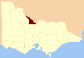 Location in Victoria | |||||||||||||||
| |||||||||||||||
The County of Gunbower was proclaimed in 1871, with others from the Loddon Land District. The name is an aboriginal word.
Parishes
Parishes include:
- Cohuna, Victoria
- Gannawarra, Victoria
- Gunbower, Victoria
- Gunbower West, Victoria
- Kerang, Victoria
- Loddon, Victoria
- Macorna, Victoria
- Millewa, Victoria
- Mincha, Victoria
- Mincha West, Victoria
- Mologa, Victoria
- Murrabit, Victoria
- Murrabit West, Victoria
- Patho, Victoria
- Terrick Terrick East, Victoria
- Terrick Terrick West, Victoria
- Tragowel, Victoria
- Torrumbarry, Victoria
- Torrumbarry North, Victoria
- Wharparilla, Victoria
- Yarrowalla, Victoria
gollark: But how can you overclock downloaded RAM? It doesn't show up in your BIOS stuff.
gollark: And you can only download 2400MHz RAM, you see, which is problematic.
gollark: I've always found downloaded RAM to be a bit unreliable, myself.
gollark: Because Windows just downloads more RAM when it runs out, obviously, due to its integrated nature.
gollark: Unfortunately, it seems that 2 VS Code windows and Switchcraft is too much for my RAM or something.
References
- Vicnames, place name details
- Research aids, Victoria 1910
- County of Gunbower, Cadastral map showing parish boundaries and land ownership, 1890. National Library of Australia
This article is issued from Wikipedia. The text is licensed under Creative Commons - Attribution - Sharealike. Additional terms may apply for the media files.