Panitya, Victoria
Panitya is a locality situated in the Sunraysia region. The place by road, is situated about 23 kilometres east from Pinnaroo and 10 kilometres west from Carina on the Mallee Highway.
| Panitya Victoria | |||||||||||||||
|---|---|---|---|---|---|---|---|---|---|---|---|---|---|---|---|
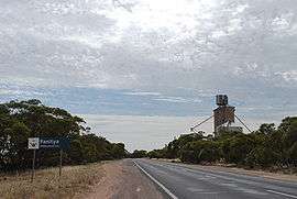 Entering Panitya | |||||||||||||||
 Panitya | |||||||||||||||
| Coordinates | 35°14′10″S 140°59′30″E | ||||||||||||||
| Postcode(s) | 3512 | ||||||||||||||
| Elevation | 91 m (299 ft) | ||||||||||||||
| Location | |||||||||||||||
| LGA(s) | Rural City of Mildura | ||||||||||||||
| State electorate(s) | Mildura | ||||||||||||||
| Federal Division(s) | Mallee | ||||||||||||||
| |||||||||||||||
Panitya is a railway station on the Ouyen to Pinnaroo line.
The Post Office opened in 1910 and was closed in 1975.[2]
The area of the locality contains a number of smaller areas, namely Panitya East which had a post office open from 1916 until 1933, Berrook which had a post office open from 1929 until 1935, Manya with a post office from 1928 until 1936, Sunset with a post office from 1921 until 1948 and, below the Mallee Highway, Ngallo.[2]
Notes and references
- Travelmate
- Premier Postal History, Post Office List, retrieved 11 April 2008
gollark: He's clearly just an AI created to popularise Krist...
gollark: If you already believe "hahahahaha i'm right because tjwld is most intelligent" then that will affect your actions.
gollark: And also just pointless anyway.
gollark: And that's one very very inaccurate test.
gollark: You could be deliberately being slower or whatever.
This article is issued from Wikipedia. The text is licensed under Creative Commons - Attribution - Sharealike. Additional terms may apply for the media files.