Columbus metropolitan area, Georgia
The Columbus, Georgia Metropolitan Statistical Area, as defined by the United States Census Bureau and colloquially known as the Chattahoochee Valley, is an area consisting of four counties in Georgia and one county in Alabama, anchored by the city of Columbus. As of the 2010 census, the MSA had a population of 296,506 (though a July 1, 2016 estimate placed the population at 308,755).[1] The Columbus metropolitan area is a component of the Columbus-Auburn-Opelika (GA-AL) Combined Statistical Area, a trading and marketing region.

Counties
Note: In 2018, the U.S. Census Bureau revised the official area definition of the Columbus, Georgia Metropolitan Statistical Area. Two additional Georgia counties, Stewart and Talbot, will be included in all statistics of the 2020 decennial census and in all annual population estimates after 2018.[2]
Communities
Places with more than 180,000 inhabitants
- Columbus, Georgia (principal city)
Places with 10,000 to 50,000 inhabitants
- Cusseta, Georgia (includes Fort Benning)
- Phenix City, Alabama
Places with 1,000 to 10,000 inhabitants
- Buena Vista, Georgia
- Hamilton, Georgia
- Ladonia, Alabama (census-designated place)
- Lumpkin, Georgia
- Manchester, Georgia (partial)
- Pine Mountain, Georgia (partial)
- Richland, Georgia
- West Point, Georgia (partial)
Places with less than 1,000 inhabitants
Demographics
As of the census[3] of 2000, there were 281,768 people, 103,982 households, and 72,632 families residing within the MSA. The racial makeup of the MSA was 54.56% White, 40.21% African American, 0.40% Native American, 1.22% Asian, 0.14% Pacific Islander, 1.01% from other races, and 1.74% from two or more races. Hispanic or Latino of any race were 4.02% of the population.
The median income for a household in the MSA was $35,262, and the median income for a family was $40,065. Males had a median income of $29,196 versus $22,834 for females. The per capita income for the MSA was $16,410.
Combined Statistical Area
See also
- Georgia census statistical areas
- Alabama census statistical areas
References
- "Table 1. Annual Estimates of the Population of Metropolitan and Micropolitan Statistical Areas: April 1, 2000 to July 1, 2016 (CBSA-EST2009-01)" (CSV). 2016 Population Estimates. United States Census Bureau, Population Division. 2010-03-23. Retrieved 2010-03-24.
- https://www.whitehouse.gov/wp-content/uploads/2018/09/Bulletin-18-04.pdf
- "U.S. Census website". United States Census Bureau. Retrieved 2008-01-31.

Greater Columbus, Georgia | ||
|---|---|---|
| Central cities/Largest cities | 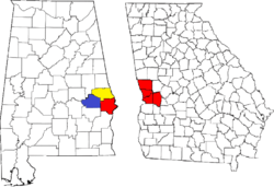 Location of the Columbus, Georgia-Auburn, Alabama CSA and its counties:
Columbus, Georgia Metropolitan Statistical Area
Auburn, Alabama Metropolitan Statistical Area
Tuskegee, Alabama Micropolitan Statistical Area (defunct) | |
| Cities in Georgia | ||
| Cities in Alabama | ||
| Counties in Georgia | ||
| Counties in Alabama | ||
Montgomery (capital) | ||
| Topics | ||
| Society |
| |
| Regions | ||
| Flora and fauna | ||
| Largest cities | ||
| Metros |
| |
| Counties |
| |
