Champdolent
Champdolent is a commune in the Charente-Maritime department in the Nouvelle-Aquitaine region in southwestern France.
Champdolent | |
|---|---|
The town hall in Champdolent | |
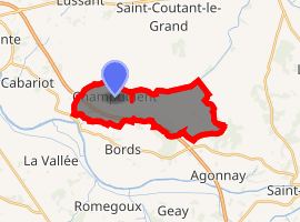
Location of Champdolent 
| |
 Champdolent  Champdolent | |
| Coordinates: 45°55′12″N 0°48′01″W | |
| Country | France |
| Region | Nouvelle-Aquitaine |
| Department | Charente-Maritime |
| Arrondissement | Saint-Jean-d'Angély |
| Canton | Saint-Jean-d'Angély |
| Government | |
| • Mayor (2008–2014) | Jean-Claude Sicard |
| Area 1 | 12.02 km2 (4.64 sq mi) |
| Population (2017-01-01)[1] | 400 |
| • Density | 33/km2 (86/sq mi) |
| Time zone | UTC+01:00 (CET) |
| • Summer (DST) | UTC+02:00 (CEST) |
| INSEE/Postal code | 17085 /17430 |
| Elevation | 1–35 m (3.3–114.8 ft) (avg. 6 m or 20 ft) |
| 1 French Land Register data, which excludes lakes, ponds, glaciers > 1 km2 (0.386 sq mi or 247 acres) and river estuaries. | |
Geography
The Boutonne forms the commune's northern and western borders.
Population
| Year | Pop. | ±% |
|---|---|---|
| 1962 | 366 | — |
| 1968 | 375 | +2.5% |
| 1975 | 332 | −11.5% |
| 1982 | 299 | −9.9% |
| 1990 | 328 | +9.7% |
| 1999 | 372 | +13.4% |
| 2008 | 389 | +4.6% |
gollark: Much of my data is just nonexistent for the past 10ish minutes.
gollark: System load is nominal, great.
gollark: It's automated.
gollark: Of course they do. And browsers WILL force HTTPS at all times on my site for security.
gollark: Probably. I can't actually get into the server to check.
References
- "Populations légales 2017". INSEE. Retrieved 6 January 2020.
| Wikimedia Commons has media related to Champdolent. |
This article is issued from Wikipedia. The text is licensed under Creative Commons - Attribution - Sharealike. Additional terms may apply for the media files.