Cabariot
Cabariot is a commune in the Charente-Maritime department in southwestern France.
Cabariot | |
|---|---|
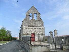 The church in Cabariot | |
Location of Cabariot 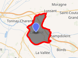
| |
 Cabariot  Cabariot | |
| Coordinates: 45°55′36″N 0°51′21″W | |
| Country | France |
| Region | Nouvelle-Aquitaine |
| Department | Charente-Maritime |
| Arrondissement | Rochefort |
| Canton | Tonnay-Charente |
| Intercommunality | Rochefort Océan |
| Government | |
| • Mayor (2014-2020) | Claude Champagne |
| Area 1 | 15.12 km2 (5.84 sq mi) |
| Population (2017-01-01)[1] | 1,341 |
| • Density | 89/km2 (230/sq mi) |
| Time zone | UTC+01:00 (CET) |
| • Summer (DST) | UTC+02:00 (CEST) |
| INSEE/Postal code | 17075 /17430 |
| Elevation | 1–27 m (3.3–88.6 ft) |
| 1 French Land Register data, which excludes lakes, ponds, glaciers > 1 km2 (0.386 sq mi or 247 acres) and river estuaries. | |
Geography
The Boutonne forms part of the commune's southeastern border, then flows into the Charente River, which forms all of its southwestern border.
Population
| Year | Pop. | ±% |
|---|---|---|
| 2004 | 1,143 | — |
| 2006 | 1,149 | +0.5% |
| 2007 | 1,193 | +3.8% |
| 2008 | 1,235 | +3.5% |
| 2009 | 1,277 | +3.4% |
| 2010 | 1,307 | +2.3% |
| 2011 | 1,330 | +1.8% |
| 2012 | 1,328 | −0.2% |
| 2013 | 1,322 | −0.5% |
| 2014 | 1,317 | −0.4% |
| 2015 | 1,323 | +0.5% |
| 2016 | 1,324 | +0.1% |
gollark: Yet my pattern terminal operates.
gollark: Contingency Measure 86Y initiatlized.
gollark: My Minecraft client is nearly loaded, of course, but in the meantime I can use the turtle swarms for interaction.
gollark: I'm sure you find it beneficial to imagine so.
gollark: GTech™ inevitably, and inescapably™.
References
- "Populations légales 2017". INSEE. Retrieved 6 January 2020.
| Wikimedia Commons has media related to Cabariot. |
| Authority control |
|
|---|
This article is issued from Wikipedia. The text is licensed under Creative Commons - Attribution - Sharealike. Additional terms may apply for the media files.