Ardillières
Ardillières is a commune in the Charente-Maritime department in the Nouvelle-Aquitaine region of southwestern France.
Ardillières | |
|---|---|
.JPG) The road into Ardillières | |
Location of Ardillières 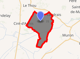
| |
 Ardillières  Ardillières | |
| Coordinates: 46°03′32″N 0°53′29″W | |
| Country | France |
| Region | Nouvelle-Aquitaine |
| Department | Charente-Maritime |
| Arrondissement | Rochefort |
| Canton | Surgères |
| Intercommunality | Aunis Sud |
| Government | |
| • Mayor (2008–2020) | Jean-Marie Targé |
| Area 1 | 15.7 km2 (6.1 sq mi) |
| Population (2017-01-01)[1] | 849 |
| • Density | 54/km2 (140/sq mi) |
| Time zone | UTC+01:00 (CET) |
| • Summer (DST) | UTC+02:00 (CEST) |
| INSEE/Postal code | 17018 /17290 |
| Elevation | 0–31 m (0–102 ft) (avg. 17 m or 56 ft) |
| 1 French Land Register data, which excludes lakes, ponds, glaciers > 1 km2 (0.386 sq mi or 247 acres) and river estuaries. | |
The inhabitants of the commune are known as Ardilliérois or Ardilliéroises[2]
Geography
Ardillières is located some 25 km south-east of La Rochelle and 20 km east of Châtelaillon-Plage. Access to the commune is by the D111 road from Ciré-d'Aunis in the west passing through the commune and the village and continuing to the east. The D208 road also goes north-east from the village to join the D939 at Le Cher. The D205E2 also goes north-west from the village to Le Thou. Apart from the village there are also the hamlets of Les Perrieres, Toucherit, Villeneuve, and Bois des Mottes. The commune is entirely farmland apart from a few small patches of forest.[3]
The southern portion of the commune is covered with a network of canals which link to the Charras Canal which crosses the south of the commune from west to east.[3]
Neighbouring communes and villages[3]
Places adjacent to Ardillières | ||||||||||
|---|---|---|---|---|---|---|---|---|---|---|
| ||||||||||
Administration
.JPG)
List of Successive Mayors[4]
| From | To | Name | Party | Position |
|---|---|---|---|---|
| 1826 | 1830 | Etienne Martin | ||
| 1971 | 2001 | Guy Caquineau | SE | |
| 2001 | 2020 | Jean-Marie Targé | SE |
(Not all data is known)
Demography
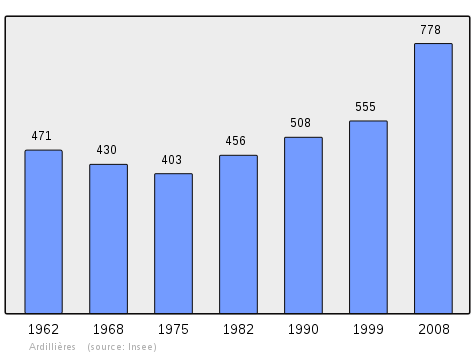
In 2009 the commune had 782 inhabitants. The evolution of the number of inhabitants is known from the population censuses conducted in the commune since 1793. From the 21st century, a census of communes with fewer than 10,000 inhabitants is held every five years, unlike larger towns that have a sample survey every year.[Note 1]
| 1793 | 1800 | 1806 | 1821 | 1831 | 1836 | 1841 | 1846 | 1851 |
|---|---|---|---|---|---|---|---|---|
| 560 | 486 | 501 | 496 | 684 | 759 | 756 | 793 | 843 |
| 1856 | 1861 | 1866 | 1872 | 1876 | 1881 | 1886 | 1891 | 1896 |
|---|---|---|---|---|---|---|---|---|
| 819 | 860 | 830 | 850 | 834 | 819 | 775 | 680 | 663 |
| 1901 | 1906 | 1911 | 1921 | 1926 | 1931 | 1936 | 1946 | 1954 |
|---|---|---|---|---|---|---|---|---|
| 607 | 604 | 588 | 485 | 502 | 454 | 425 | 409 | 444 |
| 1962 | 1968 | 1975 | 1982 | 1990 | 1999 | 2006 | 2009 | - |
|---|---|---|---|---|---|---|---|---|
| 471 | 430 | 403 | 456 | 508 | 555 | 735 | 782 | - |
Distribution of Age Groups
The population of the town is relatively young. The ratio of persons above the age of 60 years (16.5%) is lower than the national average (21.6%) and the departmental average (28.1%). Unlike national and departmental allocations, the male population of the town is greater than the female population (50.1% against 48.4% nationally and 48.2% at the departmental level).
Percentage Distribution of Age Groups in Ardillières and Charente-Maritime Department in 2009
| Ardillières | Ardillières | Charente-M | Charente-M | |
|---|---|---|---|---|
| Age Range | Men | Women | Men | Women |
| 0 to 14 Years | 24.5 | 27.2 | 17.2 | 15.1 |
| 15 to 29 Years | 13.3 | 14.1 | 16.5 | 14.4 |
| 30 to 44 Years | 27.8 | 28.2 | 18.7 | 17.9 |
| 45 to 59 Years | 18.6 | 13.3 | 21.0 | 20.8 |
| 60 to 74 Years | 11.7 | 10.5 | 17.2 | 17.8 |
| 75 to 89 Years | 4.1 | 6.2 | 9.0 | 12.4 |
| 90 Years+ | 0.0 | 0.5 | 0.5 | 1.5 |
Sources:
Culture and heritage
Civil heritage
The commune has several sites and buildings that are registered as historical monuments:
- The Château d'Ardillières (14th century).

- The Pierre Levée Dolmen (Neolithic)
- The Pierre-Fouquerée Dolmen (Neolithic)
- Other sites of interest
- The Charras Canal
- A Mill (Charles Goumard built it in the early 16th century). It contains a Lintel (1508)

- A Wind Farm
- Rural cottages
Religious heritage
The Parish Church of Saint Peter (11th century)![]()
![]()
Ardillières Picture Gallery
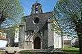 The Church of Saint Peter
.JPG) The entrance to the church
The entrance to the church.JPG) The side of the church
The side of the church.JPG) The War Memorial
The War Memorial
Notable people linked to the commune
- Pierre Le Moyne d'Iberville, Squire of Iberville and Ardillières, founder of the Louisiana colony in 1700 where he built the Fort of Biloxi.
See also
External links
- Ardillières on the National Geographic Institute website (in French)
- Ardillières on Lion1906
- Ardillières on Géoportail, National Geographic Institute (IGN) website (in French)
- Ardillières on the 1750 Cassini Map
Notes and references
Notes
- At the beginning of the 21st century, the methods of identification have been modified by Law No. 2002-276 of 27 February 2002 , the so-called "law of local democracy" and in particular Title V "census operations" allows, after a transitional period running from 2004 to 2008, the annual publication of the legal population of the different French administrative districts. For communes with a population greater than 10,000 inhabitants, a sample survey is conducted annually, the entire territory of these communes is taken into account at the end of the period of five years. The first "legal population" after 1999 under this new law came into force on 1 January 2009 and was based on the census of 2006.
References
- "Populations légales 2017". INSEE. Retrieved 6 January 2020.
- Inhabitants of Charente-Maritime (in French)
- Google Maps
- List of Mayors of France
- Ministry of Culture, Mérimée IA17006687 Château d'Ardillières (in French)

- Ministry of Culture, Mérimée PA00104598 Pierre Levée Dolmen (in French)
- Ministry of Culture, Mérimée PA00104597 Pierre-Fouquerée Dolmen (in French)
- Ministry of Culture, Palissy PM17000014 Lintel (in French)
- Ministry of Culture, Mérimée IA17006695 Parish Church of Saint Peter (in French)
- Ministry of Culture, Palissy PM17000013 Bronze Bell (in French)
| Wikimedia Commons has media related to Ardillières. |
| Authority control |
|---|