31st parallel north

The 31st parallel north is a circle of latitude that is 31 degrees north of the Earth's equatorial plane. It crosses Africa, Asia, the Pacific Ocean, North America and the Atlantic Ocean.

31°
31st parallel north
Sign marking the 31st parallel north at Cape Sata, Japan
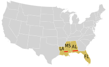
In the United States, the 31st parallel defines part of the border between Mississippi and Louisiana, and part of the border between Alabama and Florida.

Part of the border between Iran and Iraq is defined by the parallel. In the United States, it defines part of the border between the states of Mississippi and Louisiana, and most of the border between Alabama and Florida.

Andrew Ellicott surveyed this parallel in 1797, when it was the border between the United States and Spanish territory.

At this latitude the sun is visible for 14 hours, 10 minutes during the summer solstice and 10 hours, 8 minutes during the winter solstice.[1]

Around the world

Starting at the Prime Meridian and heading eastwards, the parallel 31° north passes through:

Co-ordinates Country, territory or sea Notes
31°0′N 0°0′E  Algeria
31°0′N 9°22′E  Tunisia
31°0′N 10°17′E  Libya
31°0′N 17°33′E Mediterranean Sea Gulf of Sidra
31°0′N 20°8′E  Libya
31°0′N 24°56′E  Egypt
31°0′N 28°43′E Mediterranean Sea
31°0′N 29°35′E  Egypt
31°0′N 34°21′E  Israel Passing just north of Yeruham
31°0′N 35°24′E  Jordan
31°0′N 37°30′E  Saudi Arabia Passing through Arar
31°0′N 42°14′E  Iraq Passing through Nasiriyah
31°0′N 47°42′E  Iran /  Iraq border
31°0′N 48°1′E  Iran
31°0′N 61°50′E  Afghanistan
31°0′N 66°35′E  Pakistan Balochistan
Punjab
31°0′N 74°33′E  India Punjab
Himachal Pradesh
Uttarakhand
31°0′N 79°32′E  People's Republic of China Tibet
Sichuan
Chongqing
Hubei
Anhui
Zhejiang
Jiangsu
Zhejiang - for about 5 km
Jiangsu - for about 5 km
Zhejiang - for about 11 km
Shanghai
31°0′N 121°53′E East China Sea
31°0′N 130°39′E  Japan Cape Sata, the southernmost point of the island of Kyūshū
31°0′N 130°41′E Pacific Ocean
31°0′N 116°20′W  Mexico Baja California
31°0′N 114°50′W Gulf of California
31°0′N 113°6′W  Mexico Sonora
Chihuahua
31°0′N 105°33′W  United States Texas
Louisiana
Mississippi / Louisiana border
Mississippi
Alabama
Alabama / Florida border
Georgia
31°0′N 81°28′W Atlantic Ocean
31°0′N 9°49′W  Morocco
31°0′N 3°33′W  Algeria
gollark: Not when you sell at twice the prices, hydro!
gollark: It's a backwards shop.
gollark: I do buy *manually* when I'm on.
gollark: To maintain a monopoly.
gollark: Hydronitrogen is keeping the code closed source.

See also

References

This article is issued from Wikipedia. The text is licensed under Creative Commons - Attribution - Sharealike. Additional terms may apply for the media files.