2020 Easter tornado outbreak
A widespread and deadly tornado outbreak affected the Southeastern United States on Easter Sunday and Monday, April 12–13, 2020. Several tornadoes were responsible for prompting tornado emergencies, including the first one to be issued by the National Weather Service in Charleston, South Carolina[5]. A large squall line formed and tracked through the mid-Atlantic on April 13, prompting more tornado warnings and watches. A total of 15 watches were produced during the course of the event, two of which were designated Particularly Dangerous Situations.
Part of the tornado outbreaks of 2020 | |
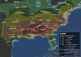 Map of tornado warnings and confirmed tornadoes from the outbreak | |
| Type | Tornado outbreak Extratropical cyclone |
|---|---|
| Duration | April 12–13, 2020 |
| Tornadoes confirmed | 140 |
| Max. rating1 | EF4 tornado |
| Duration of tornado outbreak2 | 37 hours, 24 minutes |
| Highest winds |
|
| Largest hail | 4 in (10 cm) in diameter – Del Rio and Brackettville, Texas, on April 11[3] |
| Damage | $3 billion (2020 USD)[4] |
| Power outages | 1.44 million customers at one time; over 4.3 million in total |
| Casualties | 32 fatalities (+6 non-tornadic) |
| Areas affected | Southeastern United States, Mid-Atlantic |
| 1Most severe tornado damage; see Enhanced Fujita scale 2Time from first tornado to last tornado | |
Throughout the two-day outbreak, a total of 140 tornadoes touched down across 10 states, inflicting widespread and locally catastrophic damage. The strongest tornado was rated high-end EF4 and occurred in Southern Mississippi, producing estimated winds of 190 mph (310 km/h), reaching a width of 2.25 mi (3.62 km), and causing eight deaths. With a total of 32 tornado-related fatalities, it was the deadliest tornado outbreak since April 27–30, 2014. To assist with recovery efforts, governors of five states declared a state of emergency. Relief efforts were complicated by social distancing requirements amid the ongoing coronavirus pandemic.
Meteorological synopsis
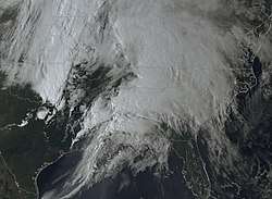
For weeks throughout March and into April, an expansive area of high pressure built across the Southeast United States,[6] contributing to abnormally warm temperatures across much of the country. The United States as a whole experienced its seventeenth warmest March, continuing the pattern that persisted throughout winter. In particular, many locations along the U.S. and Mexican Gulf coasts saw record warmest temperatures for the month.[7] Calm weather associated with the high-pressure area induced rapid warming of the Gulf of Mexico waters to their highest values in the modern record—greater than 2 °C (3.6 °F) above the 1971–2010 average—as well as a moistening of the air near the surface.[6][8] Increased instability associated with anomalously warm and moist air from the Gulf of Mexico has been associated with an increased risk of severe weather and tornado activity.[9]
The first indications of organized severe weather came on April 8, when the Storm Prediction Center (SPC) outlined 15% probabilities for severe weather within 25 mi (40 km) of a point from central Texas eastward into the Florida Panhandle and eastern Georgia valid for April 11–12.[10] These threat areas were later refined with the introduction of a day-3 moderate risk, the fourth of five threat levels, across northeastern Louisiana through central Alabama on April 10.[11] Historically, the SPC issues one day-3 moderate risk every year, and half of those over the previous decade were later upgraded to High risk, the highest threat level.[12] Over subsequent days, a significant mid-level shortwave trough progressed eastward across the United States. By the pre-dawn hours of April 12, mid-level cooling associated with the feature overspread the Edwards Plateau, Hill Country, and much of central Texas. Accordingly, an intense line of severe thunderstorms developed along a dry line while vigorous convective development formed farther east.[13] These thunderstorms were initially isolated in nature but soon coalesced into a mesoscale convective system as they encountered an enhanced corridor of warm air streaming northward, as well as very strong wind shear. These initial storms produced scattered weak tornadoes in Texas during the early stages of the outbreak.[14][15] This storm complex progressed across northern Louisiana through the late morning and early afternoon hours, and embedded circulations within the line began producing strong tornadoes, contributing to multiple tornado debris signatures visible on radar.[16] One such tornado in Monroe was rated EF3 strength, and damaged or destroyed numerous homes.[17] In advance of the line, a lifting warm front aided in the formation of a very moist, highly unstable, and highly sheared environment across and northeastern Louisiana and much of Mississippi.[18] Accordingly, the SPC issued a particularly dangerous situation tornado watch into the late evening hours.[19]
A weather balloon launch from Jackson, Mississippi, at 18:00 UTC revealed the presence of a capping inversion across the region. This cap was expected to weaken across central Mississippi,[20] while forecasters expressed more uncertainty about its longevity across southern Mississippi and Louisiana.[21] As a small area of low pressure progressed across northwestern Mississippi, it caused surface winds to turn out of the east-southeast, enhancing the potential for tornadoes. As a cluster of storms across central Mississippi progressed toward the northeast, it began to reintensify and develop embedded supercell characteristics with an attendant threat of strong tornadoes.[22] Farther south, two distinct supercells developed within an environment where long-tracked, significant tornadoes were favored, both exhibiting extremely strong rotation and distinct debris signatures.[23] Based on previous storm structures in similar environments, the SPC remarked that "this is an exceptionally rare event" and estimated tornadic winds of 170–205 mph (274–330 km/h) on the first supercell, consistent with a tornado of EF4 or EF5 intensity.[1][24][25] After conducting damage surveys, meteorologists identified two violent tornadoes with the first supercell, one that killed four people near Sartinville to southwest of Bassfield, and a second that killed eight people from south of Bassfield to southwest of Pachuta, both of EF4 intensity. A long-tracked EF3 tornado was identified with the second supercell that tracked behind the first one, producing significant damage near Oak Vale and Carson.[26]
Throughout the evening hours, the severe weather and tornado risk shifted eastward into Alabama, as the initial cluster of severe storms with numerous embedded semi-discrete supercells and comma-head circulation moved across north-central Alabama, contributing to multiple strong tornadoes. This included a damaging rain-wrapped EF2 that struck a residential area at the southwestern outskirts of Boaz.[27] This feature continued into northwestern Georgia, maintaining its well-defined structure in spite of a marginally unstable environment.[28] A high-end EF2 tornado spawned by an isolated supercell thunderstorm ahead of the main complex carved a path northwest of Chatsworth, Georgia and through the small community of Sumac, killing eight people. While local enhancement of storm activity occurred within an extensive line of convection in central Alabama,[29] dewpoints rose in the wake of the earlier storm complex across northern Georgia and southeastern Tennessee, further boosting instability values in the presence of extremely strong wind shear.[30] An EF3 tornado embedded within the main line of storms killed four people in the eastern suburbs and neighborhoods of Chattanooga, Tennessee.[31] During the early-morning hours of April 13, the pre-frontal squall line shifted eastward into eastern Georgia and the Carolinas, with numerous well-organized embedded supercells forming within the line, producing many strong tornadoes across the region. An EF3 tornado was confirmed south of Thomaston to northwest of Redbone in Georgia.[32] A second EF3 tornado from south-southeast of Westminster to west of Central in South Carolina killed one person and caused major damage in Seneca.[33] Yet another EF3 tracked from east-northeast of Elko to west-southwest of St. Matthews in South Carolina caused two more fatalities.[34] The most significant tornado to occur on April 13 was a multiple-vortex EF4 that killed five people near the South Carolina towns of Estill and Nixville. A total of eight separate EF3 tornadoes were confirmed across Georgia and South Carolina during this portion of the outbreak. Through the late morning hours of April 13, the line of intense thunderstorms continued eastward and intensified given marginal daytime heating, a steady stream of rich moisture, and intense low-level wind shear.[35] The SPC had already outlined an Enhanced risk of severe weather along the U.S. East Coast from southeastern Georgia northward into northern Virginia and damaging winds and tornadoes were reported until the storms moved offshore. Later, more severe storms formed over the Appalachian Mountains and moved into the Northeast megalopolis, where a Slight risk had been issued. These storms produced large swaths of damaging winds and isolated tornadoes throughout this area for the rest of day until the outbreak came to an end.[36]
Confirmed tornadoes
| EFU | EF0 | EF1 | EF2 | EF3 | EF4 | EF5 | Total |
|---|---|---|---|---|---|---|---|
| 0 | 31 | 74 | 19 | 13 | 3 | 0 | 140 |
Monroe, Louisiana
| EF3 tornado | |
|---|---|
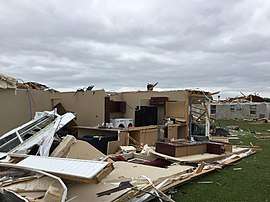 EF3 damage to a house in Monroe, Louisiana. | |
| Max. rating1 | EF3 tornado |
| Highest winds |
|
| Damage | $250 million (2020 USD)[37] |
| Casualties | None |
| 1Most severe tornado damage; see Enhanced Fujita scale | |
This strong rain-wrapped tornado first touched down just south-southwest of Brownsville-Bawcomville, Louisiana at 11:36 a.m. CDT (16:36 UTC). It caused EF1 damage as numerous trees were snapped or uprooted at the intersection of Brown Street and Evergreen Street and in neighborhoods to the northeast as the tornado moved toward Monroe. Several of these trees landed on homes, and a metal building had its overhead door blown out. In addition, several manufactured homes along Sandal Street were damaged. A trailer was tipped over at LA 34 before the tornado reached EF2 strength as it moved into West Monroe. Power poles in this area were snapped, metal trusses were broken at a paper mill, and a wood chip conveyor belt was blown over.[17][38] The tornado maintained EF2 intensity, crossed the Ouachita River two times, and impacted Riverbend Drive. In this area, many trees were snapped, a home lost its roof, and another home sustained partial wall collapse. The tornado then crossed the Ouachita River a third time and impacted neighborhoods along Business US 165 and LA 15 to the south of downtown Monroe, where a tornado emergency was issued. Multiple homes in this area had roofs torn off and a few of them also sustained some collapse of exterior walls. A large two-story home lost all of its roof, and an art museum also had severe roof damage. Numerous other homes in this area sustained roofing and window damage, and many trees and power poles were downed. Continuing northeast of Railroad Avenue, the tornado momentarily weakened to EF1 intensity as moved through additional residential areas, downing more trees and damaging the roofs of homes. Regaining EF2 strength, the tornado crossed Interstate 20 at US 165, heavily damaging a metal building and snapping several power poles along LA 594.[17][39] The tornado then reached its peak intensity as multiple well-built homes in a subdivision along Orchid Drive had roofs ripped off and multiple exterior walls collapsed, and numerous other homes sustained varying degrees of damage. Damage in this area was rated high-end EF2 to EF3. Sporadic EF1 damage was observed as the tornado proceeded to cross Powell Avenue, where homes sustained partial roof loss and trees were damaged. Northeast of this area, the tornado strengthened back to EF2 intensity as it completely destroyed a metal hangar at Monroe Regional Airport. A large metal building was also heavily damaged in this area before the tornado abruptly lifted and dissipated as it crossed an airport runway. Damage to the airport was estimated at US$25–30 million.[37]
The tornado lasted for 9 minutes, traveled 8.01 miles (12.89 km), and was given a rating of low-end EF3. Throughout Ouachita Parish, a total of 458 homes were impacted; 23 were destroyed, 108 had major damage, and 243 had minor damage. Despite the extensive damage, there were no casualties from the tornado.[37]
Hope–Sartinville–Bassfield, Mississippi
| EF4 tornado | |
|---|---|
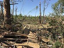
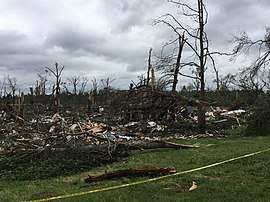 Denuded and partially debarked trees, and debris from a mobile home that was obliterated by the EF4 tornado. | |
| Max. rating1 | EF4 tornado |
| Highest winds |
|
| Casualties | 4 fatalities, at least 3 injuries |
| 1Most severe tornado damage; see Enhanced Fujita scale | |
This large and violent wedge tornado touched down just southwest of the rural Walthall County, Mississippi community of Hope, near Jefferson Road and to the east of the intersection with Jack Foil Road. The tornado quickly became strong as it moved northeastward through Hope, producing low-end EF2 damage. Rapid strengthening and widening continued as the tornado inflicted more significant damage while crossing MS 27. As it passed to the east of Sartinville, the tornado reached its peak intensity as it completely swept away a house near James Ratcliff Road, leaving only a bare foundation slab behind. This house was anchor-bolted to its foundation, though nearby trees did not sustain damage consistent with a tornado stronger than low-end EF4 strength. The anchor bolts were bent up to 90 degrees, and the foundation around the bolts was partially cracked. One tree on the property was ripped out the ground and thrown several feet. A nearby house was leveled with only a pile of debris remaining, though it was not well-anchored, and a high-end EF3 rating was applied at that location.[26][40] Northeast of this area, the tornado weakened back to EF2 strength as it snapped numerous trees, damaged several small cinder-block buildings, tore the roof off a home, and rolled a tied-down mobile home as it crossed East Sartinville Road. Crossing into the southern part of Lawrence County, the tornado reintensified to EF3 strength, denuding and partially debarking numerous trees. A double-wide mobile home was completely obliterated along Tynes Ainsworth Road, with the metal frame lofted and thrown 150 yd (140 m). A large storage garage was completely swept away in this area as well. The tornado then weakened back to EF2 intensity as it crossed Felix Road and Holmes Road, as several power poles were snapped and a large swath of trees was flattened. A one-story house at the edge of the damage path had shingles ripped off as well. EF2 damage to trees and power poles continued through unpopulated areas of northwestern Marion County until the tornado crossed River Road and Cooper Road, where EF1 tree damage occurred. Continuing into the southwestern corner of Jefferson Davis County, the weakening tornado produced EF0 to EF1 tree and tree limb damage before dissipating at Joe Dyess Road, several miles to the southwest of Bassfield, Mississippi.[40]
This tornado was on the ground for 21.21 mi (34.13 km) and reached a peak width of 1,320 yd (1,210 m), killing four people and injuring at least three others. It was rated as a low-end EF4, with winds estimated at around 170 mph (270 km/h).[26]
Bassfield–Soso–Moss–Pachuta, Mississippi
| EF4 tornado | |
|---|---|
 | |
| Max. rating1 | EF4 tornado |
| Highest winds |
|
| Casualties | 8 fatalities, at least 95 injuries |
| 1Most severe tornado damage; see Enhanced Fujita scale | |
Six minutes after the first EF4 tornado lifted far southwest of Bassfield, the same parent supercell thunderstorm produced another violent, long-tracked wedge tornado that touched down just south-southwest of the town.[26] A tornado emergency remained in effect for Bassfield due to the first tornado, giving substantial warning as the second developed.[41] The first area of damage occurred along Bassfield Cemetery Road and Bass Road, where trees and tree limbs were downed at EF0 to EF1 intensity.[40] The tornado quickly intensified as it continued to the northeast and crossed Ray Hathorn Road and South Williamsburg Road, reaching EF2 strength as it snapped and uprooted numerous large trees. Mainly EF2 damage continued within the vicinity of MS 42 just southeast of Bassfield as multiple homes sustained partial to total roof loss, and a mobile home was rolled. A small area of low-end EF3 damage along Hosey Mikel Road, where a mobile home was completely obliterated and swept away, with little debris recovered. Northeast of this point, the tornado became violent and expanded to one mile wide, as EF4-level tree damage began to occur along Pitts Lane and Reese Road. Every tree in this area was snapped or sustained severe debarking, and another mobile home was obliterated, with the damage to that structure rated EF3. A house farther away from the center of the path sustained severe roof damage as well. EF4 tree damage continued to the northeast through the intersection of Graves Key Road and Harper Road, and one tree was found with a metal mobile home frame wrapped around it. Four people were killed in this area as Mama D's, a small restaurant housed in a cinder-block building, was leveled and swept away, with the concrete slab foundation largely swept clean of debris. This structure was not well-anchored, and a high-end EF3 rating was applied to the restaurant. Cars in this area were thrown and mangled, and several homes sustained EF2 to EF3 damage, sustaining roof and exterior wall loss.[40]
The tornado then reached its peak strength as it tore through the rural community of Cantwell Mill, where a large, anchor-bolted cabin was completely swept away and reduced to a bare slab, with little debris recovered. While this structure was well-anchored, surveyors noted some minor structural defects including lack of external sheathing and flawed stud-to-sill plate nailing, while nearby trees sustained only partial debarking, and no significant ground scouring was observed. It was also noted that a vehicle may have impacted the structure as the tornado struck. Due to these limiting factors, a high-end EF4 rating was applied as a result. A truck was lofted from this location and thrown 300 yd (270 m) into a field as well, leaving it mangled beyond recognition. Extreme EF4-level tree damage continued to the northeast, along Willie Fortenberry Road, Davis Road, and Kings Road as entire groves of large trees were mowed down and completely stripped clean of all bark, livestock was killed, and vehicles were thrown hundreds of yards and destroyed. A few homes farther away from the center of the path sustained EF2 to EF3 damage, with their roofs ripped off and exterior walls collapsed.[40]
The massive tornado continued to grow in size, reaching its peak width of 2.25 mi (3.62 km) west of Seminary. An entire forest was leveled with significant debarking to some trees, while thousands to millions of other trees were damaged.[26] Multiple vortices and an intense core were evident in the damage path, and dozens of chicken houses were completely destroyed. A manufactured home was obliterated, frame homes had roofs ripped off and exterior walls collapsed, and multiple vehicles were thrown and rolled along this segment of the path, and most of the damage was rated EF3. However, one small pocket of low-end EF4 damage occurred along Cold Springs Road, where a well-built brick house was almost entirely leveled.[26] A tornado emergency was extended east-northeast downwind of the storm for Seminary and Collins, Mississippi; one of several issued for the storm.[41] The Storm Prediction Center issued a mesoscale discussion stating that a tornado with winds of 170–205 mph (274–330 km/h) was likely ongoing, and that it was an 'exceptionally rare event'.[42] The tornado then narrowed to 1.7 miles (2.7 km), but continued to produce EF3 damage as it crossed US 49 to the north-northwest of Seminary. Numerous trees were snapped and partially debarked, and two homes sustained collapse of their exterior walls in this area, while two others had much of their roofs ripped off. EF2 to EF3 damage continued as the tornado moved through rural areas to the northeast of Seminary, moving into Jones County and crossing US 84. Damage along this portion of the path consisted of mobile homes, metal buildings, outbuildings, and poultry barns destroyed, along with frame homes sustaining roof and exterior wall loss. Massive tree damage continued to occur, with large swaths of trees snapped, denuded, and partially debarked.[40]
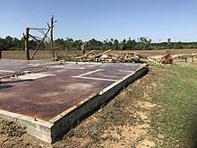
The tornado then moved through the small town of Soso, damaging or destroying multiple homes, some churches, and the local fire department building. Numerous trees were snapped throughout town, and several mobile homes were destroyed. Most of the damage in Soso was rated EF3, though a small area of low-end EF4 damage occurred along MS 28, where a well-built concrete block convenience store was completely leveled.[26] The tornado weakened to EF2 intensity as it continued to the northeast of Soso, where more trees were downed and numerous mobile homes were destroyed. Metal buildings were damaged, and outbuildings were destroyed as well. A house along Matthews Road had much of its roof torn off, and a nearby vehicle was rolled down a hill and badly mangled. After crossing MS 15 and entering Jasper County, the tornado intensified back to low-end EF4 intensity as it struck the community of Moss, where nearly every structure in town was damaged and numerous homes were destroyed. Several of these homes were flattened with only piles of rubble remaining, and one was left with only a single concrete closet standing. Half of the First Baptist Church was leveled, and a pickup truck was thrown hundreds of yards and completely destroyed. Continuing northeast of Moss, the tornado began to weaken, producing EF1 to EF2 damage. Several homes and mobile homes had metal roofing peeled back or decking exposed. Large swaths of trees were snapped for several miles, including some along Interstate 59 between the Heidelberg and Vossburg exits. Barns and outbuildings were destroyed along this segment of the path, and some power poles were snapped. Northeast of Vossburg, the tornado weakened further, inflicting EF1 damage to trees and a mobile home. EF1 damage continued as the tornado crossed into Clarke County and struck the town of Pachuta. Damage in Pachuta consisted of trees downed and moderate roof damage. North-northeast of Pachuta, the tornado finally dissipated at County Road 320, after causing some additional minor EF0 tree limb damage.[26][40]
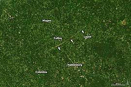
The tornado was estimated by the NWS to have been 2.25 mi (3.62 km) wide, making it the widest tornado in Mississippi state history, and the third-widest on record in the United States, just behind the 2004 Hallam tornado and the 2013 El Reno tornado. A total of eight fatalities and at least 95 injuries occurred along the path.[43][44] The tornado was also long-tracked, with a path length of 68 miles. Damage was severe to the point the path of the tornado could be seen from satellite imagery.[45] The tornado was given a high-end EF4 rating with estimated winds of 190 mph (310 km/h).[26] Debris from the tornado was carried considerable distances, with a photo from a destroyed home in Moss being found 121 miles away in Tuscaloosa, Alabama, while another one was lofted and carried 176 miles from south of Collins, Mississippi to Randolph, Alabama.[46][47]
Topeka–Oak Vale–Carson–Rose Hill, Mississippi
| EF3 tornado | |
|---|---|
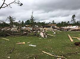 Remains of the James Hill Church, which was leveled at EF3 strength to the northeast of Carson, Mississippi. | |
| Max. rating1 | EF3 tornado |
| Highest winds |
|
| Casualties | At least 2 injuries |
| 1Most severe tornado damage; see Enhanced Fujita scale | |
This strong, long-tracked wedge tornado was spawned by a supercell thunderstorm that tracked closely behind, and just north of the supercell that produced the previous two EF4 tornadoes. It first touched down along Price Road in Lawrence County, Mississippi, east-southeast of the small community of Topeka. Damage at the beginning of the path consisted of a few trees uprooted at EF0 strength. The tornado continued to the northeast, quickly reaching EF2 intensity as it crossed Given Road, where a large swath of trees was flattened. EF2 damage continued to the northeast, with many large trees being snapped and uprooted. A house along Rayborn Lane sustained EF1 roof damage, and two nearby sheds were damaged as well. The tornado strengthened further and reached EF3 strength as it moved through a wooded area near the Pearl River, where a log cabin was destroyed numerous trees were snapped and partially debarked. After crossing the Pearl River, the tornado passed near Oak Vale where some homes sustained roof and exterior wall loss, numerous trees were snapped, a metal building was destroyed, and damage was rated EF2 to EF3. Crossing into Jefferson Davis County, EF2 damage occurred in areas to the northeast of Oak Vale, where numerous trees and power poles were snapped, outbuildings were destroyed, homes sustained severe roof damage, and a mobile home was destroyed. A small area of EF3 damage occurred along Kirkley Lane, where some trees were denuded and partially debarked. A home and an outbuilding farther away from the center of the damage path sustained EF1 damage as well. Additional EF2 damage occurred to the west and north of Carson, where a small business housed in a manufactured structure was completely destroyed, many trees were downed, and two well-built homes had their roofs torn off. EF2 damage continued to the northeast of Carson, where several mobile homes were destroyed, another house had its roof ripped off, and multiple other homes sustained less severe roof damage.[40]
Crossing MS 35, the tornado again attained EF3 strength as the James Hill Church was completely leveled, a nearby home sustained collapse of its exterior walls, and trees were denuded and partially debarked. Multiple mobile homes were also destroyed in this area, and power poles were snapped. Additional EF3 tree damage occurred along Terrell Road before the tornado crossed into Covington County. EF3 tree damage continued along Three Notch Road, while a mobile home and two frame homes were destroyed nearby. The tornado weakened back to EF2 intensity as it approached and crossed US 84, snapping and uprooting numerous trees and destroying numerous chicken houses. As the tornado continued to the northeast, it produced EF1 to EF2 damage as it approached and crossed US 49 to the northwest of Collins, downing many trees, some of which landed on homes and mobile homes. A small silo was blown over, outbuildings were destroyed, a mobile home was blown away and destroyed, and some houses sustained roof damage. Crossing Jones Chapel Road to the northeast, the tornado weakened to EF1 strength, with damage limited to downed trees. EF1 tree and outbuilding damage continued through the northwestern corner of Jones County and the southwestern corner of Smith County, and a church sustained some damage along this segment of the path as well. EF1 damage continued into Jasper County, where a house and a chicken farm were damaged, and many trees were downed in and around the small community of Stringer. EF1 tree and outbuilding damage continued along the remainder of the path and through the rural community of Paulding until the tornado dissipated along County Road 31 to the south of Rose Hill.[26][40]
Remaining on the ground for 84.1 mi (135.3 km), this was the longest-tracked tornado of the outbreak. It reached a peak width of 2,040 yd (1,870 m), and resulted in at least two injuries, but no fatalities. It was rated mid-range EF3.[26]
Chatsworth–Fashion–Sumac–Cisco, Georgia
| EF2 tornado | |
|---|---|
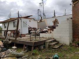 EF2 damage to a house in Sumac, Georgia. | |
| Max. rating1 | EF2 tornado |
| Highest winds |
|
| Damage | $500,000 (2020 USD)[48] |
| Casualties | 8 fatalities, 24 injuries |
| 1Most severe tornado damage; see Enhanced Fujita scale | |
An EF0 tornado touched down along Mitchell Bridge Road, just northwest of Chatsworth near the Indian Trace Golf Course and headed north-northeast, snapping or uprooting some trees and causing minor roof and siding damage to several homes. The tornado began to grow in size and reached EF1 intensity after crossing SR 286 and moving into a neighborhood just southwest of Fashion. Exterior damage to homes became more severe, and numerous trees were snapped and uprooted. One home in this area had a large portion of its roof torn off. The tornado then downed a large swath of trees before crossing Norton Bridge Road and reaching EF2 strength. It then moved through the west side of Fashion, obliterating at least eight double-wide manufactured homes along Deer Park Drive while damaging several others. Continuing north-northeast, additional manufactured homes were destroyed as the tornado paralleled SR 225 and crossed Ridgeview Lane and Fieldview Court. The tornado then reached its peak intensity as a recently built cell tower was blown over and crumpled at high-end EF2 intensity. The tornado maintained EF2 intensity as it moved into the southern part of the rural community of Sumac and crossed Zion Hill Church Road. A mobile home was destroyed in this area, a small frame home had its roof torn off and sustained partial exterior wall collapse, and numerous trees were snapped. A few other nearby homes sustained roof damage as well. The tornado then weakened slightly, but maintained EF2 intensity as it crossed SR 255 and moved directly through the central part of Sumac, where a house was destroyed and a few others sustained minor damage. It also heavily damaged a large metal chicken house in this area. The tornado then began to weaken and narrow as it continued north, where it destroyed or damaged multiple chicken houses along Jim Petty Road. Debris from these structures was scattered hundreds of yards away, and damage in this area was rated high-end EF1 to EF2. The tornado weakened further as it continued to the north-northeast at EF0 strength, downing a few trees and causing minor damage to an outbuilding. EF0 damage continued as the tornado downed a few tree limbs along Halls Chapel Road, and then lifted just before reaching Sumac Ridge to the southwest of Cisco.[40]
The tornado was on the ground for 10 minutes, traveled 8.88 miles (14.29 km), had a maximum width of 860 yards (790 m), and was given a rating of high-end EF2. Eight people were killed by the tornado, including one person who died of his injuries the following month. A total of 24 other people were injured.[49][32][50] A tornado warning was not issued for the storm until the tornado had already been on the ground for eight minutes.[51]
Fort Oglethorpe, Georgia/Chattanooga–Ooltewah, Tennessee
| EF3 tornado | |
|---|---|
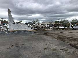 EF3 damage to an auto-parts store in the East Brainerd area of Chattanooga, Tennessee. | |
| Max. rating1 | EF3 tornado |
| Highest winds |
|
| Damage | ≥$250,000 (2020 USD)[52][53][54] |
| Casualties | 2 fatalities, 18 injuries |
| 1Most severe tornado damage; see Enhanced Fujita scale | |
Around 11:15 p.m. EDT on April 12 (03:15 UTC, April 13), an EF0 tornado embedded within a strong QLCS touched down near Chickamauga and Chattanooga National Military Park in Fort Oglethorpe, Georgia. It moved northeast and quickly strengthened, impacting an industrial area on the south side of town at high-end EF1 strength. Multiple businesses and metal buildings along SR 2 were damaged and a weather station at the Public Works Department measured a wind gust of 106 mph (171 km/h) in this area. As the tornado tracked through Fort Oglethorpe, EF1 damage continued as a car wash was destroyed, a McDonald's was damaged, light poles were downed, and the front wall of a Sherwin-Williams paint store was blown in. Several other businesses were also damaged. Trees and tree limbs in Fort Oglethorpe were downed, and some homes and apartment buildings sustained roof damage. Thereafter, the tornado exited Fort Oglethorpe and continued to the northeast, weakening to EF0 intensity as it produced minor tree and roof damage intermittently. It then crossed Interstate 75 before moving into Tennessee, entering the eastern neighborhoods and suburbs of Chattanooga.[32] The tornado then strengthened to EF1 intensity again as it impacted the Harris Hills neighborhood, snapping and uprooting numerous trees in residential areas. It then entered the East Brainerd area and crossed East Brainerd Road, rapidly becoming strong and producing EF3 damage. An auto-parts store in this area was leveled and a strip mall was severely damaged, with a barbecue restaurant on the east side of the building completely destroyed. A nearby doctor's office building was heavily damaged as well, and East Brainerd Elementary School had its roof torn off. Dozens of homes in residential areas along this segment of the path also sustained major structural damage, some of which were large and well-built. As the tornado continued northeast, a tornado emergency was issued for Collegedale and Ooltewah. The tornado then reached its peak width as it entered the Drake Forest neighborhood of Chattanooga while still at EF3 intensity. Numerous well-built homes in this area had their roofs torn off and sustained collapse of their exterior walls, and numerous trees were snapped or denuded. EF2 to EF3 damage continued through the Holly Hills neighborhood where additional trees were snapped, power poles were downed, and many homes and apartment buildings sustained roof and exterior wall loss. Multiple buildings were severely damaged at the Grace Baptist Academy as well. The tornado then abruptly narrowed and weakened back to EF1 strength as it passed just northwest of Collegedale and directly into Ooltewah. Many trees were downed along this portion of the path, and multiple apartment buildings sustained roof damage as the tornado hit the Integra Hills Preserve Apartments. The tornado then weakened and caused EF0 strength tree damage as it crossed into Bradley County and over White Oak Mountain before dissipating south of McDonald around 11:33 p.m. (03:33 UTC).[55]
The tornado was on the ground for 18 minutes, traveled 18.37 miles (29.56 km), was 1,500 yards (1,400 m) wide, and was rated EF3.[55] Throughout the Chattanooga metropolitan area, 2,718 properties sustained damage, of which 254 were destroyed and 259 had major damage. Total damages were reported as reaching $225 million and two people were killed, while an additional 18 were injured.[31][56][57]
Westminster–Seneca–Clemson, South Carolina
| EF3 tornado | |
|---|---|
 EF3 damage to the BorgWarner plant in Seneca, South Carolina. | |
| Max. rating1 | EF3 tornado |
| Highest winds |
|
| Damage | $100 million (2020 USD)[58][59] |
| Casualties | 1 fatality, 5 injuries |
| 1Most severe tornado damage; see Enhanced Fujita scale | |
This high–end EF3 tornado initially touched down around 3:21 a.m. EDT (07:21 UTC) on April 13, touching down near Stonewall Drive to the south-southeast of Westminster, inflicting EF0 damage to homes and trees. It then moved to the northeast along the north side of South Retreat Road as it moved directly into Retreat. Trees and homes in this area suffered EF0 to EF1 damage as the tornado crossed over SC 11 and SC 24. EF1 damage continued as the tornado approached and crossed Brown Farm Road and Radisson Road. Damage rapidly became more severe and widespread as the tornado continued to the northeast and moved into more populated areas in the southwestern part of Seneca. Reaching EF3 strength, the tornado first struck a BorgWarner plant at the end of Evalona Drive, inflicting major structural damage to the facility and scattering large amounts of debris throughout the area. A security guard on the property was killed when a concrete-block guard shack was completely destroyed. A block-foundation house in this area was swept away at high-end EF3 strength, and a vehicle parked at this residence was blown into the basement. Other vehicles were flipped or damaged at the plant, and the large letter "B" from the BorgWarner sign was found in the yard of a residence in Liberty, 18 miles (29 km) away.[60] The large tornado then crossed the Wells Highway and moved through residential areas of Seneca. Many homes in this area sustained EF2 to EF3 damage, with roofs ripped off and exterior walls collapsed. Detached garages were destroyed, a gas station awning was shredded, and numerous trees and power lines were downed throughout this part of the path. The tornado had grown to a half–mile wide at this point, and various degrees of damage was inflicted to numerous other homes in Seneca. Damage severity then began to quickly lessen, and the damage path narrowed as the tornado passed through the north edge of Utica and directly into the Jordania community. Mainly EF1 damage was noted as dozens of homes were damaged along this segment of the path, and many large trees were snapped or uprooted, some of which landed on structures. The tornado maintained EF1 strength as it as it crossed US 123 and continued to the northeast, where EF1 damage was inflicted to numerous trees just north of Keowee. The tornado than crossed Hartwell Lake northwest of Clemson and produced some EF0 tree damage before lifting due-west of Central at 3:36 a.m. EDT (07:31 UTC).
The tornado was on the ground for 15 minutes, traveled 16.71 miles (26.89 km), and reached a maximum width of 1,000 yards (910 m). There was one fatality and five injuries. Damages in Seneca alone were reported as being in excess of $200 million.[33][61]
Estill–Nixville–Fechtig, South Carolina
| EF4 tornado | |
|---|---|
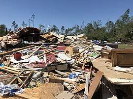 EF4 damage to a two-story house to the northeast of Nixville, South Carolina. | |
| Max. rating1 | EF4 tornado |
| Highest winds |
|
| Casualties | 5 fatalities, 65 injuries[62] |
| 1Most severe tornado damage; see Enhanced Fujita scale | |
This large, violent multiple-vortex tornado first touched down in Hampton County, South Carolina at 6:10 a.m. EDT (10:10 UTC) on April 13, west-northwest of Scotia, producing EF1-strength tree damage along Collie Road. It quickly became strong as it moved northeast, crossed Old Orangeburg Road, and impacted Federal Correctional Institution, Estill, which was significantly damaged. The damage to the medium-security prison was so severe that occupying inmates were relocated to Pennsylvania.[63] The tornado then strengthened further shortly after crossing over Steep Bottom Road and US 321 south of Estill, with EF2 to EF3 damage was inflicted to homes and mobile homes along Sprayfield Road. The tornado than crossed over the Lena Expressway and destroyed another residence at EF3 intensity before reaching it maximum width of ~3⁄4 mile (1.2 km) and mowing down a large swath of trees and destroying a cell tower. Some trees in this area were denuded and partially debarked, and vehicles were thrown/rolled 50–75 yards (46–69 m) and mangled. The tornado then turned deadly as it crossed over SC 3 and US 601 to the northwest of the small community of Nixville, killing two people in an obliterated mobile home. It then impacted another group of homes to north the of town on the Turner Expressway, heavily damaging or destroying them and killing three in the area. The tornado then moved directly through Speak Mills, crossing over 2 Sisters Ferry Road before reaching its peak intensity along Lento Road. Here, a well-built two story home was leveled with only a pile of debris remaining, and some of its debris scattered into the yard. Damage to the residence was rated EF4. Another home across the street sustained EF3 damage as well, sustaining roof and exterior wall loss. The tornado than began a weakening trend as it continued to move northeastward toward US 278. Damage was mainly limited to trees and outbuildings in this area, and the scope of the damage began to narrow and become less severe as the tornado crossed US 278 and the Coosawhatchie River before paralleling Camp Branch. It than moved away from the tributary and tracked through rural areas to the south of Varnville, producing only minor damage to trees and residences as it crossed Miles Road and SC 68. The tornado continued to inflict minor tree damage to the northeast of here before dissipating at 6:37 a.m. EDT (10:37 UTC), to the north-northeast of Fechtig near the Hampton-Colleton County line.[62][64]
The tornado was on the ground for 27 minutes, reached a maximum width of 1,300 yards (1,200 m), traveled 23.73 miles (38.19 km) and was rated EF4. The tornado killed five people in the hardest hit areas just south of Estill and in Nixville. A total of 65 others were injured, including several individuals that were thrown 30–50 yards (27–46 m) from mobile homes as well as the homes that received EF3-EF4 damage. This was the first F4 or EF4 in the state since 1995 and the first in the South Carolina Lowcountry on record. The National Weather Service Forecast Office in Charleston referred to it as an "unusually long track and wide tornado."[65] The tornado was associated with a tornado family that began in Screven County, Georgia and traveled northeast for over 150 miles (240 km) before shifting offshore in Berkeley County, South Carolina.[62]
Non-tornadic impacts
Heavy rainfall across eastern Texas led to flash flooding and multiple road closures throughout many communities. Downed trees and powerlines caused additional road closures.[66] Gusty winds in Upshur County, Texas killed one man after a tree fell on him in his driveway.[67] As the storms progressed into Arkansas, widespread damaging winds were observed, causing the collapse of old buildings and the historic Centennial Baptist Church in downtown Helena-West Helena.[68] The 9-1-1 and emergency dispatch were disrupted throughout the city, and scattered debris obstructed ambulances from reaching hospitals.[69] The strong winds toppled numerous trees, powerlines, and fences throughout the southern portions of the state.[70] Additional damage was inflicted to structures such as greenhouses, poultry farms, sheds, barns, and docks. The downed trees blocked numerous highways.[71] In White Hall, one downed tree fell onto a home and killed an occupant. More than 143,000 customers were left without power in Arkansas in the storms' wake.[72] In Mississippi, heavy rainfall overspread Panola County, where Mississippi Emergency Management Personnel donated sandbags to prevent flooding.[73] Widespread rainfall amount of 3–4 in (76–102 mm), locally exceeded 6 in (150 mm), across northern Alabama prompted significant flooding across DeKalb County. There, about 50 roadways were temporarily closed. Floodwaters inundated some businesses in Collinsville. In nearby Fort Payne, waters inundated several businesses, forcing about 35 people from the flooded areas. Multiple roads were reportedly washed out.[74] Significant flooding was likewise reported across Madison, Morgan, and Jackson counties.[75]
Farther north in Tennessee, a 33-year-old woman was swept away and drowned by rushing water at a bridge in Kimball.[31] Four bridges in total were damaged by the flooding, including three in South Pittsburg.[76] Nashville recorded a daily rainfall record of 2.23 in (57 mm).[77] Heavy rainfall fell throughout the Tennessee Valley in the wake of the wettest first three months of any year on record, causing the Chickamauga Dam and Watts Bar Lake to climb about 1.5 ft (0.46 m) above normal summertime pool levels.[78] Numerous roads were blocked in Rutherford, Williamson,[79] and Washington counties.[80] The McFarland Park in Florence was submerged as the Tennessee River spilled its banks.[81] Across Unicoi County, multiple roads were washed out. The rising waters prompted an evacuation order for the Temple Hill community.[82] High waters flowed through homes around Hampton and Valley Forge in Carter County.[83] The Beaver Creek in Bristol overflowed its banks, flooding intersections.[84] The Kingsport Fire Department rescued 21 people as the city was threatened by rising waters.[85] A total of 27 roads were closed throughout Sullivan County.[86] In northeastern Tennessee, flooding damaged two bridges in the Johnson City area. Some residents in the community of Sinking Creek were cut off as several low-level areas were inundated. In Carter County, the Gap Creek overflowed its banks and closed roadways.[87]
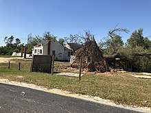
Widespread damaging winds rolled across North Carolina, leaving behind extensive damage. Approximately 200,000 people lost power state-wide.[88] A person was killed by a fallen tree in Davidson County.[89] A microburst near Wallace in Marlboro County, South Carolina, produced winds of 100–110 mph (160–180 km/h) over an area 2–3 mi (3.2–4.8 km) wide and 4–5 mi (6.4–8.0 km) long. Several homes had their roof blown off and an unanchored mobile home was flipped off its foundation. Hundreds of hardwood and softwood trees were snapped throughout the area.[2] Statewide, approximately 300,000 people lost power.[90]
Outside the warm sector of the broad system, an unseasonable snowstorm and gale-force winds affected regions from the northern Plains into the Midwestern United States. Sioux Falls, South Dakota, recorded 5.2 in (130 mm) on April 12, a daily record and the second snowiest Easter Sunday on record.[91] The Twin Cities recorded 5.1 in (130 mm) of snow, setting a new Easter Sunday record going back to 1891.[92] Accumulations totaling to nearly a foot across portions of southern Minnesota caused multiple spinouts and crashes, principally along Interstate 35 south of the Twin Cities, Interstate 90 between Albert Lea and Rochester, and U.S. Highway 52 between Rochester and the Twin Cities. Traffic, though, was lighter than usual given the stay-at-home order for the ongoing coronavirus pandemic.[93] State patrol reported 140 crashes, 126 vehicle that spun out, and 6 semi-trucks that jackknifed on slippery roads. Fourteen people were injured.[94] In Wisconsin, a band of 6–15 in (150–380 mm) accumulations fell north of a Marshfield to Wausaukee line.[95] Daily snowfall records were set in Rochester and Eau Claire.[96][97] Winds exceeding gale threshold backed up waters on the Fox and East rivers, causing minor flooding in Green Bay.[95] In Michigan, areas of the Upper Peninsula between Marquette and Munising recorded 18–24 in (460–610 mm) of snow.[98] Wave heights of 7.5–8.5 ft (2.3–2.6 m) were estimated on Lake Michigan.[99]
Powerful winds associated with the parent storm system impacted much of the Northeastern United States on April 13. Hurricane-force wind gusts were observed in Delaware and New Jersey, reaching 82 mph (132 km/h) in Island Beach State Park, New Jersey, and 79 mph (127 km/h) in Sussex County, Delaware.[100] More than 56,000 customers were left without power in New Jersey. In Cresskill, a tree fell onto a home.[101]
Aftermath and records
| State | Fatalities | Ref. |
|---|---|---|
| Arkansas | 1 | [72] |
| Georgia | 8 | [102] |
| Mississippi | 14 | [103] |
| North Carolina | 1 | [89] |
| South Carolina | 9 | [90] |
| Tennessee | 4 | [31][104] |
| Texas | 1 | [67] |
| Total | 38 | |
More than 1.44 million customers from Texas into Pennsylvania lost power at one time during the storm, and more than 4.3 million customers in total were impacted.[105] In the wake of the outbreak, recovery efforts were hampered by the ongoing pandemic and the American Red Cross resorted to readying hotel rooms, not mass shelters, for affected residents.[106] State of emergencies were declared in Louisiana, Mississippi, Alabama,[107] Georgia,[108] and South Carolina.[109] Southern Baptist disaster relief agencies established relief operations centered in Soso, Mississippi, and Chattanooga, Tennessee. Assisting members were provided personal protective equipment to reduce the risk of exposure to COVID-19.[110]
In heavy-hit Monroe, Louisiana, the National Guard was deployed to assist in debris removal.[111] Drax Biomass, headquartered in the city, donated $10,000 to tornado relief.[112] At emergency shelters, masks and gloves were provided to residents. The city sought to acquire 200 hotel rooms to house victims as a countermeasure to mass gatherings.[113]
Of Mississippi's 82 counties, 33 reported damage from the tornado and severe weather event. At least 1,200 homes and 75 businesses were damaged or destroyed and losses exceeded $10 million.[114][115] On April 18, President Donald Trump approved federal disaster declarations for Covington, Jefferson Davis, and Jones counties in Mississippi.[116] With a declaration already in effect for COVID-19, this is believed to be the first instance of concurrent federal disaster declarations in state history.[117] Collectively, 333 homes were damaged or destroyed in the counties.[116] Jones County established a base of operations in Bassfield to coordinate relief efforts. Tarps and water were supplied to affected persons. The Salvation Army assisted in providing food to displaced residents and the Sartinville United Methodist Church coordinated relief with nonprofit agencies. Power was restored to all homes capable of receiving power in Jones, Walthall, and Yazoo counties by April 18.[118] Local news agencies under the Mississippi Gray Television network—WLBT, WDAM, WLOX, WMC, and WTOK—established a fundraiser with the Red Cross. Gray Television itself donated $10,000.[119][120]
On April 14, Chattanooga, Tennessee, was toured by the state's governor, Bill Lee; it marked the second time the governor had surveyed tornado damage in a little over a month following the deadly tornado outbreak of March 2–3, 2020.[121] More than 500 emergency responders were deployed city-wide for search and rescue. Sixty-five residents of an Alzheimer's living facility were relocated to a hotel due to structural damage.[113] Through April 20, Chattanooga public works removed 3,890 tons of debris from the city. Tennessee Emergency Management Agency officials applied for a federal disaster assistance.[56]
After what was the deadliest day for tornadoes in South Carolina since the March 1984 outbreak, the Red Cross sheltered 236 displaced residents in hotels.[122] Widespread damage in Seneca, prompted a curfew for the city.[123] A medium-security prison in Hampton County, South Carolina, was directly impacted by an EF4 tornado, with resultant damage so severe that occupying inmates were relocated to Pennsylvania. The state's governor, Henry McMaster, toured the damage on April 14.[63] By April 16, 600 people utilized housing and meals from the Red Cross.[124] Throughout Orangeburg County, 54 single-family homes, 27 mobile homes, and 10 businesses suffered damage from tornadoes; total losses reached $2.98 million.[125] Pickens County reported $1 million in damage.[126]
For the 24-hour period ending 12:00 UTC April 13, the National Weather Service issued 141 tornado warnings, the most in one day since the tornado outbreak of March 2–3, 2012.[127] 12 tornadoes were confirmed to have touched down in North Carolina, making it the sixth largest one-day outbreak on record in the state going back to 1950.[128] With 12 significant (EF2+) tornadoes recorded statewide—eight of which were rated at EF3 or stronger—the outbreak set records for the greatest number of EF2+ tornadoes registered in a single day in South Carolina. With nine fatalities, the outbreak was also the second deadliest on record in the state since 1950, behind only the outbreak of March 28, 1984.[129]
See also
- 1994 Palm Sunday tornado outbreak, a similar deadly tornado outbreak in the same regions
- Tornado outbreak of April 23, 2000, another tornado outbreak that occurred on Easter Sunday in 2000
References
- Nick Nauslar; John Hart. "Storm Prediction Center Mesoscale Discussion 360". Storm Prediction Center.
- "Wallace SC Microbursts". Iowa Environmental Mesonet. National Weather Service Forecast Office in Wilmington, North Carolina. April 14, 2020. Retrieved April 15, 2020.
- "20200411's Storm Reports (20200411 1200 UTC - 20200412 1159 UTC)". Storm Prediction Center. April 15, 2020. Retrieved April 15, 2020.
- "Billion-Dollar Weather and Climate Disasters: Events | National Centers for Environmental Information (NCEI)". www.ncdc.noaa.gov. Retrieved August 7, 2020.
- "This was the first one issued by our office". Twitter. Retrieved August 9, 2020.
- "Summerlike Heat Will Set Record-High Temperatures in Parts of the South Into This Weekend". The Weather Channel. March 23, 2020. Retrieved April 12, 2020.
- Bob Henson (April 8, 2020). "U.S. Stays on a Warm, Mostly Wet Track in March". Weather Underground. Retrieved April 12, 2020.
- Bob Henson (April 12, 2020). "Severe Outbreak to Rip from Texas to Mid-Atlantic Sunday into Monday". Weather Underground. Retrieved April 12, 2020.
- Matthew Cappucci (March 31, 2020). "Abnormally warm Gulf of Mexico could intensify the upcoming tornado and hurricane seasons". The Washington Post. Retrieved April 12, 2020.
- Andy Dean; Greg Dial. "Day 4-8 Severe Weather Outlook Issued on Apr 8, 2020". Storm Prediction Center.
- Andy Dean; Greg Dial. "Storm Prediction Center Apr 10, 2020 0730 UTC Day 3 Severe Thunderstorm Outlook". Storm Prediction Center.
- Matthew Cappucci (April 10, 2020). "Severe weather likely in South on Easter weekend, including powerful tornadoes". The Washington Post. Retrieved April 12, 2020.
- Brynn Kerr; Rich Thompson. "Storm Prediction Center Mesoscale Discussion 345". Storm Prediction Center.
- Brynn Kerr. "Storm Prediction Center Mesoscale Discussion 346". Storm Prediction Center.
- Brynn Kerr. "Storm Prediction Center Mesoscale Discussion 348". Storm Prediction Center.
- Aaron Gleason. "Storm Prediction Center Mesoscale Discussion 351". Storm Prediction Center.
- Eleven Tornadoes Confirmed in April 12th Event (Report). Iowa Environmental Mesonet. National Weather Service Weather Forecast Office in Shreveport, Louisiana. April 15, 2020. Retrieved April 15, 2020.
- Aaron Gleason; Jeremy Grams. "Storm Prediction Center Mesoscale Discussion 350". Storm Prediction Center.
- Jeremy Grams. "Storm Prediction Center PDS Tornado Watch 106". Storm Prediction Center.
- Aaron Gleason. "Storm Prediction Center Mesoscale Discussion 357". Storm Prediction Center.
- Jeremy Grams; Aaron Gleason. "Storm Prediction Center Mesoscale Discussion 353". Storm Prediction Center.
- Aaron Gleason. "Storm Prediction Center Mesoscale Discussion 355". Storm Prediction Center.
- Nick Nauslar; John Hart. "Storm Prediction Center Mesoscale Discussion 362". Storm Prediction Center.
- Steve Goss. "Storm Prediction Center Mesoscale Discussion 368". Storm Prediction Center.
- Steve Goss. "Storm Prediction Center Mesoscale Discussion 369". Storm Prediction Center.
- NWS Damage Survey For 04/12/2020 Tornado Event- Update #8 (Report). Iowa Environmental Mesonet. National Weather Service Weather Forecast Office in Jackson, Mississippi. April 17, 2020. Retrieved April 17, 2020.
- Steve Goss (April 12, 2020). "Mesoscale Discussion Number 363". Storm Prediction Center. Retrieved April 14, 2020.
- Steve Goss (April 12, 2020). "Mesoscale Discussion Number 369". Storm Prediction Center. Retrieved April 14, 2020.
- Steve Goss (April 12, 2020). "Mesoscale Discussion Number 371". Storm Prediction Center. Retrieved April 14, 2020.
- Steve Goss (April 12, 2020). "Mesoscale Discussion Number 373". Storm Prediction Center. Retrieved April 14, 2020.
- "Update: NWS: "At least an EF3" tornado struck Chattanooga Sunday night, 10 dead in area". WTCV. April 13, 2020. Retrieved April 13, 2020.
- NWS Damage Survey for 04/12-13/2020 Tornado Event (Report). Iowa Environmental Mesonet. National Weather Service Weather Forecast Office in Peachtree City, Georgia. April 22, 2020. Retrieved April 22, 2020.
- NWS Damage Survey for EF3 Tornado Event (Report). Iowa Environmental Mesonet. National Weather Service Weather Forecast Office in Greenville-Spartanburg, South Carolina. April 13, 2020. Retrieved April 13, 2020.
- Summary of All Damage Surveys in Central SC and East-Central GA for the April 13, 2020 Tornado Event (Report). Iowa Environmental Mesonet. National Weather Service Weather Forecast Office in Columbia, South Carolina. April 17, 2020. Retrieved April 17, 2020.
- Brynn Kerr (April 13, 2020). "Mesoscale Discussion Number 379". Storm Prediction Center. Retrieved April 14, 2020.
- Elizabeth Leitman (April 13, 2020). "Apr 13, 2020 0600 UTC Day 1 Convective Outlook". Storm Prediction Center. Retrieved April 14, 2020.
- Louisiana Event Report: EF3 Tornado. National Weather Service (Report). National Centers for Environmental Information. Retrieved July 17, 2020.
- "Tornado Warning". Iowa Environmental Mesonet. National Weather Service Weather Forecast Office in Shreveport, Louisiana. April 12, 2020. Retrieved April 14, 2020.
- KNOE. "NWS: Three tornadoes hit Ouachita Parish on Easter Sunday". www.knoe.com. Retrieved April 17, 2020.
- "NWS Damage Assessment Toolkit". National Oceanic and Atmospheric Administration. 2020. Retrieved April 25, 2020.
- "IEM :: Valid Time Event Code (VTEC) App". Iowa Environmental Mesonet. Iowa State University. Retrieved April 13, 2020.
- M.Ed, Bryan Schuerman (April 12, 2020). "UPDATE: @NWSSPC has chimed in with those two supercell thunderstorms that has tornadoes on them, one of them being extremely violent... saying this is an EF-4 to EF-5 tornado, calling it an exceptionally rare event... #MSWX pic.twitter.com/PAloI1h9FX". @BSchuermanWX. Retrieved April 17, 2020.
- "More Than Two-Mile-Wide Mississippi Easter Tornado, One of Largest Ever Documented in U.S., Was State's Widest on Record". The Weather Channel. Retrieved April 17, 2020.
- Michaels, Chris (April 17, 2020). "Mississippi tornado becomes third-widest on record, according to the National Weather Service". WSLS. Retrieved April 17, 2020.
- "Satellite Images Show the Scar From Long-Track EF4 Mississippi Tornado on Easter Sunday". The Weather Channel. Retrieved April 17, 2020.
- Spann, James (April 14, 2020). "This picture has been identified. It was lofted by an EF-4 at Moss, Mississippi. Traveled 121 miles to Tuscaloosa County Alabama. One of those that lived in the home is in critical condition". @spann. Retrieved April 17, 2020.
- Spann, James (April 14, 2020). "This photo was found by Michelle Gewalt at Randolph, AL. The bride in the picture is Heather Lail. It was at a family member's home in Collins, MS, hit by an EF-4 tornado Sunday. The pic was in a container in a shed that is no longer there; it was lofted and carried 176 miles". @spann. Retrieved April 20, 2020.
- Georgia Event Report: EF2 Tornado. National Weather Service (Report). National Centers for Environmental Information. Retrieved July 17, 2020.
- "EMA Director: 8th Murray County resident dies of tornado-related injuries". newschannel9.com. WTVC. May 8, 2020. Retrieved April 18, 2020.
- ""War zone:" At least 7 dead in Murray County from Sunday's storms, at least 23 injured". WTVC. April 13, 2020. Retrieved April 13, 2020.
- "TORFFC". Iowa Environmental Mesonet. April 12, 2020. Retrieved April 23, 2020.
- Georgia Event Report: EF1 Tornado. National Weather Service (Report). National Centers for Environmental Information. Retrieved July 17, 2020.
- Tennessee Event Report: EF3 Tornado. National Weather Service (Report). National Centers for Environmental Information. Retrieved July 17, 2020.
- "Tennessee Event Report: EF0 Tornado". National Weather Service. National Centers for Environmental Information. Retrieved July 17, 2020.
- NWS Damage Survey for 04/12/2020 Tornado Event Update #2 (Report). Iowa Environmental Mesonet. National Weather Service Weather Forecast Office in Morristown, Tennessee. April 18, 2020. Retrieved April 18, 2020.
- "Chattanooga Tornado Damage Put At $225 Million; 2,718 Properties Suffered Damages From Easter Storm". The Chattanoogan. April 21, 2020. Retrieved April 21, 2020.
- Alund, Natalie (April 16, 2020). "Four-year-old boy among those killed after tornado tears through Chattanooga". tennessean.com. Tennessean. Retrieved May 18, 2020.
- South Carolina Event Report: EF3 Tornado. National Weather Service (Report). National Centers for Environmental Information. Retrieved July 17, 2020.
- South Carolina Event Report: EF0 Tornado. National Weather Service (Report). National Centers for Environmental Information. Retrieved July 17, 2020.
- Acoba, Paulo (April 16, 2020). "The F3 tornado that hit Seneca, South Carolina carried that letter over 18 miles away". tiremeetsroad.com. Tire Meets Road. Retrieved May 13, 2020.
- Asia Wilson (April 17, 2020). "More than $200 million in property damages projected after Seneca tornado". WSPA. Retrieved April 18, 2020.
- South Carolina Event Report: EF4 Tornado. National Weather Service (Report). National Centers for Environmental Information. Retrieved July 17, 2020.
- Lou Bezjak; Stephen Fastenau (April 15, 2020). "Tornado damage forces federal prison in SC to move inmates out of state". The State. Retrieved April 15, 2020.
- "NWS Damage Assessment Toolkit". apps.dat.noaa.gov. Retrieved July 15, 2020.
- National Weather Service Forecast Office in Charleston, South Carolina [@NWSCharlestonSC] (April 24, 2020). "The Hampton County, SC tornado from 4/13 has been upgraded to an EF-4 tornado. It becomes the first F/EF-4 on record in the Lowcountry region of SC and the first F/EF-4 tornado in SC since 11/7/1995 (Marion County). Details here bit.ly/2xadSm4. #scwx" (Tweet). Retrieved April 24, 2020 – via Twitter.
- Matthew Copeland (April 12, 2020). "NWS confirms EF-1 tornado in Harrison County, damage, flooding reported in several area across East Texas". KYTX. Retrieved April 13, 2020.
- Alex Leroux (April 13, 2020). "Upshur County man dies after tree falls on him during storm". KLTV. Retrieved April 13, 2020.
- Camille Connor (April 13, 2020). "Strong storms strike Helena-West Helena, Arkansas over Easter weekend". WMC-TV. Retrieved April 13, 2020.
- Zachary Downes (April 12, 2020). "Severe storms bring flooding, high winds and damages to Mid-South". WREG-TV. Retrieved April 13, 2020.
- "Easter Sunday Arkansas storm damage reports from National Weather Service". KLRT-TV. April 12, 2020. Retrieved April 13, 2020.
- "SPC Storm Reports for 04/12/20". Storm Prediction Center. April 12, 2020. Retrieved April 16, 2020.
- "1 dead after tree falls on home in White Hall". KATV. April 13, 2020. Retrieved April 13, 2020.
- "Panola County hit by severe floods". WHBQ-TV. April 12, 2020. Retrieved April 13, 2020.
- Steven Stiefel (April 13, 2020). "Flood waters damage DeKalb bridges, homes and businesses". Times-Journal. Retrieved April 13, 2020.
- Will Robinson-Smith (April 13, 2020). "Storm Damage, Flooding Reported across North America". WAAY-TV. Retrieved April 13, 2020.
- Collins Parker (April 13, 2020). "Marion County reports one flooding fatality in the storms". WDEF-TV. Retrieved April 13, 2020.
- Natalie Neysa Alund; Brinley Hineman (April 13, 2020). "At least 21 people hospitalized, fatalities reported after storms and EF-3 tornado batter Chattanooga area". The Tennessean. Retrieved April 13, 2020.
- Dave Lessner (April 13, 2020). "Lake levels, river currents rise as Tennessee Valley receives a month's worth of rain in 18 hours". Chattanooga Free Press. Retrieved April 13, 2020.
- "Storms cause flooding, prompt water rescue". WTVF. April 12, 2020. Retrieved April 13, 2020.
- Preston Ayres (April 13, 2020). "Flooding Blocks Roads in Washington Co., TN". WCYB-TV. Retrieved April 13, 2020.
- Elizabeth Gentle (April 13, 2020). "McFarland Park filling up with water; Tennessee River spills over banks". WAFF. Retrieved April 13, 2020.
- Preston Ayres (April 13, 2020). "Flooding Reported Monday Morning". WCYB-TV. Retrieved April 13, 2020.
- "Flooding in Carter County". WCYB-TV. April 13, 2020. Retrieved April 13, 2020.
- "Overnight storms leave flooding and power outages in Bristol". WYCB-TV. April 13, 2020. Retrieved April 13, 2020.
- Slater Teague (April 13, 2020). "Kingsport Fire Department rescues 21 from community threatened by floodwaters". WJHL-TV. Retrieved April 13, 2020.
- Kristen Gallant (April 13, 2020). "Flooding in Sullivan County closes more than two dozen roads". WJHL-TV. Retrieved April 13, 2020.
- "Northeast Tennessee flooded overnight, several roads impassable". Johnson City Press. April 13, 2020. Retrieved April 13, 2020.
- Mitchell Willetts (April 13, 2020). "Destructive storms' aftermath captured in photos and on video in North Carolina". The Charlotte Observer. Retrieved April 16, 2020.
- "Storms tear through US south, leaving at least 20 people dead". The Guardian. April 13, 2020. Retrieved April 13, 2020.
- Bristow Marchant (April 15, 2020). "On top of coronavirus, SC tornado damage now officially a 2nd emergency". The State. Retrieved April 16, 2020.
- "Easter Storm Brings Snow & Wind Across the Region". National Weather Service. National Weather Service Weather Forecast Office in Sioux Falls, South Dakota. April 13, 2020. Retrieved April 13, 2020.
- Ron Trenda (April 12, 2020). "Impressive Sunday snow totals; cool start to the week, then temps rebound by Thursday". KNOW-FM. Retrieved April 13, 2020.
- Andrew Krueger (April 12, 2020). "Spring storm brings heavy snow to southern Minnesota". KNOW-FM. Retrieved April 13, 2020.
- "Easter lays an egg, nearly a foot of snow in parts of Minnesota". KARE. April 13, 2020. Retrieved April 13, 2020.
- "April 12–13 Snow/Wind Storm Summary". National Weather Service. National Weather Service Weather Forecast Office in Green Bay, Wisconsin. April 13, 2020. Retrieved April 13, 2020.
- "Record-breaking Easter Sunday snowfall". KTTC. April 13, 2020. Retrieved April 13, 2020.
- "A record Easter snowfall for Eau Claire". WEAU. April 12, 2020. Retrieved April 13, 2020.
- "Some areas of the U.P. got nearly two feet of snow – in April..." WXYZ-TV. April 13, 2020. Retrieved April 13, 2020.
- "Warning: 'Dangerous Conditions' As Waves Rise Over 8 Feet On Lake Michigan". WWJ. April 13, 2020. Retrieved April 13, 2020.
- National Weather Service Forecast Office in Mount Holly, New Jersey [@NWS_MountHolly] (April 14, 2020). "Here's a list of the strongest measured wind gusts from Monday's powerful storm system. A complete list of gusts and wind damage reports can be found here: tinyurl.com/rpzju43. A list of rainfall reports can be found here: tinyurl.com/qtjqa5b. #NJwx #DEwx #PAwx #MDwx" (Tweet). Retrieved April 15, 2020 – via Twitter.
- Zurita, Anthony. "Thousands of power outages reported across North Jersey as storm moves through the state". North Jersey.
- "Death toll rises for 2-day outbreak of storms in the South". ABC News. The Associated Press. April 16, 2020. Retrieved April 16, 2020.
- Jacob Gallant (April 16, 2020). "Death toll from Easter Sunday storms rises to 14". WLBT3. Retrieved April 16, 2020.
- Sarah Grace Taylor (April 16, 2020). "Hamilton County estimates as much as $300 million in damage, 450 people displaced after deadly storms". Chattanooga Times Free Press. Retrieved April 16, 2020.
- PowerOutages.us [@PowerOutage_us] (April 17, 2020). "April 2020 Storm Summary 2020/04/12 - 2020/04/16. Max customers out at one time: 1.44 Million. Total customers affected: Over 4.3 Million. 399k in #NorthCarolina, 391k in #SouthCarolina, 353k in #Texas, 243k #Alabama, 226k #Virginia, 204k #Arkansas" (Tweet). Retrieved April 17, 2020 – via Twitter.
- "No hugs or handshakes: Pandemic complicates storm relief". WTSP. April 15, 2020. Retrieved April 16, 2020.
- Marc Nathanson (April 13, 2020). "6 dead, half a million without power as storms batter South". ABC News. Retrieved April 13, 2020.
- "Kemp declares state of emergency for severe weather damage". WTVC. April 13, 2020. Retrieved April 15, 2020.
- Tyria Goines (April 15, 2020). "McMaster declares state of emergency for Monday's severe weather event". Retrieved April 15, 2020.
- Diana Chandler (April 15, 2020). "Disaster relief crews deal with tornadoes during COVID-19". Baptist Standard. Retrieved April 18, 2020.
- "April 15: Monroe officials address tornado aftermath". KNOE-TV. April 15, 2020. Retrieved April 16, 2020.
- "Drax Biomass donates $30,000 to help communities affected by COVID-19 and Easter tornadoes". KTVE. April 15, 2020. Retrieved April 15, 2020.
- Ron Brackett and Jan Wesner Childs (April 13, 2020). "Tornado Outbreak Tears Across the South, Killing 33". The Weather Channel. Retrieved April 16, 2020.
- "Mississippi disaster declaration approved for Easter storms". The Meridian Star. Associated Press. April 17, 2020. Retrieved April 18, 2020.
- Lici Beveridge (April 21, 2020). "Mississippi tornadoes: What we know about the April 19 storms. One tornado was massive". Jackson Clairon Ledger. Retrieved April 21, 2020.
- "Three Mississippi Counties Declared Federal Disasters Following Easter Storms". Mississippi Emergency Management Agency. April 17, 2020. Retrieved April 18, 2020.
- Ellen Ciurczak (April 17, 2020). "Tornado survivors in three Mississippi counties urged to apply for federal assistance". Hattiesburg American. Retrieved April 18, 2020.
- Justin Vicory (April 18, 2020). "Mississippi tornadoes: 'Still a lot of work to do' in counties struck by Easter storms". Mississippi Clarion Ledger. Retrieved April 18, 2020.
- "Mississippi Strong: WDAM, Red Cross team up for tornado relief fundraiser". WDAM. April 16, 2020. Retrieved April 18, 2020.
- "WTOK, Red Cross partner to help Mississippi tornado victims". WTOK. April 15, 2020. Retrieved April 18, 2020.
- "Tennessee Governor Bill Lee tours 2nd round of tornado damage within weeks". WZTV. April 15, 2020. Retrieved April 16, 2020.
- "Gov. McMaster issues state of emergency after severe weather in SC". WSAV-TV. April 15, 2020. Retrieved April 16, 2020.
- Jon Randall (April 13, 2020). "City of Seneca says curfew will go into effect Monday night following deadly storms". Fox Carolina. Retrieved April 13, 2020.
- Noah Fitt (April 16, 2020). "More tornadoes possible after SC was just hit by at least 16, weather officials say". The State. Retrieved April 16, 2020.
- Bardley Harris (April 21, 2020). "FEMA to survey tornado damage; storm losses now estimated at almost $3M". The Times and Democrat. Retrieved April 21, 2020.
- Jason Evans (April 21, 2020). "Estimates for storm damage cost top $1M". Pickens County Courier. Retrieved April 21, 2020.
- Daryl Herzmann [@akrherz] (April 13, 2020). "My unofficial data has 141 Tornado Warnings issued by the @NWS for the 12z to 12z (7 AM CDT) period ending this morning (13 April 2020). This is the largest number of warnings since 285 on 2-3 March 2012. 27-28 Apr 2011 is largest on record at 450" (Tweet). Retrieved April 14, 2020 – via Twitter.
- Kathie Dello [@KathieDello] (April 14, 2020). "It ranks as the 6th most number of confirmed tornadoes in 1 day in North Carolina, dating back to 1950 (s/o to Tim for asking the q)" (Tweet). Retrieved April 14, 2020 – via Twitter.
- South Carolina State Climatology Office (April 21, 2020). "South Carolina Tornado Outbreak 4/13/2020 (Preliminary Report)" (PDF) (Press release). Columbia, South Carolina: South Carolina Department of Natural Resources. National Weather Service. Retrieved April 22, 2020.
External links
- Easter Tornado Outbreak 2020: Major Tornadoes Tear Through Mississippi, Georgia, Tennessee, & More on YouTube