Tornado outbreak of May 15–17, 2013
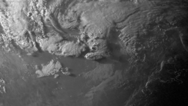
The tornado outbreak of May 15–17, 2013 was a small but intense and deadly tornado outbreak that produced several damaging tornadoes in northern Texas, south-central Oklahoma, northern Louisiana, and northern Alabama. In mid-May 2013, an upper-level shortwave trough tracked across the Southern Plains of the United States. An associated low-pressure area and atmospheric instability resulted in the formation of tornadoes across northern Texas and Oklahoma on May 15. Afterwards the storm system weakened as it tracked westward, though six additional tornadoes were reported in Texas, Louisiana, and Alabama in the two days following May 15.[1][2] Over a period of nearly two days, the storm system produced 26 tornadoes in four states. The strongest of these was an EF4 tornado which struck Hood County, Texas on May 15. However, on May 16 and May 17 no tornadoes were confirmed to have been stronger than EF1 intensity. In addition to tornadoes, large hail was reported, peaking at 4 in (10 cm) in diameter near Mineral Wells, Texas on May 15.
Part of the Tornadoes of 2013 | |
 | |
| Type | Tornado outbreak |
|---|---|
| Duration | May 15–17, 2013 |
| Tornadoes confirmed | 26 |
| Max. rating1 | EF4 tornado |
| Duration of tornado outbreak2 | 1 day, 21 hours, 13 minutes |
| Highest winds |
|
| Largest hail | 4 in (10 cm) in diameter (Mineral Wells, Texas on May 15) |
| Damage | US$272 million |
| Casualties | 6 fatalities (63 injuries) |
| 1Most severe tornado damage; see Enhanced Fujita scale 2Time from first tornado to last tornado | |
The EF4 tornado in Hood County, Texas, accounted for all six deaths caused by the severe storms, making it the first deadly tornado event in Texas since the 2007 Piedras Negras-Eagle Pass tornadoes.[3] An additional 63 people were injured, many of which were due to the same EF4 tornado. A second tornado, rated EF3, was similarly damaging and impacted areas southwest of Cleburne, Texas, injuring seven. Damage across the four states due to the storm system reached roughly $272 million in damage.
Meteorological synopsis

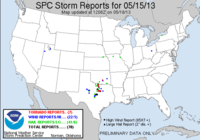
The outbreak was caused by an upper-level shortwave trough that moved northeastward from Mexico into the Southern Plains states during the nighttime the morning of May 15. The Storm Prediction Center (SPC) in Norman, Oklahoma, a division of the National Weather Service, initially issued a slight risk of severe thunderstorms early that morning over northwestern Texas, for a threat of large hail and damaging winds.[4] A low-pressure area associated with the trough moved over Oklahoma that day, producing light to moderate rainfall and non-severe thunderstorms across that state into parts of North Texas. Later forecasts expanded the slight risk further into northern and central Texas, and later into far southern Oklahoma, and indicated an enhanced risk of a few isolated tornadoes in north Texas.[5]
The atmosphere began to destabilize due to a decrease in cloud cover over western and central Texas; the sunshine and heating, combined with sufficient wind shear and abundant low-level moisture, combined to produce a very unstable air mass. The SPC issued a severe thunderstorm watch from southern Oklahoma to central Texas that afternoon around 3:00 p.m. CDT.[6] Supercells broke out in parts of northwestern Texas during the late afternoon hours, one of which developed the first tornado of the day at 5:38 p.m., near Belcherville in Montague County. A second tornado spawned by the same storm, rated as an EF1, touched down near Lake Amon G. Carter, damaging four homes and destroying one. As forecasters realized that conditions now favored tornadic activity, the SPC issued a tornado watch from far southern Oklahoma into central Texas at 6 p.m. CDT, replacing parts of the original severe thunderstorm watch.[6]
At 7:13 p.m. CDT, storm spotters reported a large tornado on the ground near Millsap in Parker County, which caused roof damage to several homes in the town. This tornado remained on the ground as another tornado began to intensify near Mile Marker 409 on Interstate 20 southeast of Weatherford, Texas at 7:19 p.m. NWS doppler radar briefly detected both tornadoes, indicating the storm was a cyclical supercell (a type of supercell that can produce successive tornadoes), before the Millsap tornado finally dissipated.[6]

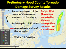
An EF4 tornado hit the town of Granbury, Texas in Hood County around 8 p.m. CDT, damaging or destroying around 100 homes and killing at least six people, with the most severe damage occurring in the Rancho Brazos neighborhood; the Granbury storm was the first violent tornado to hit North Texas since an F4 twister that killed three people in Lancaster in Dallas County on April 25, 1994.[7] The supercell that produced the Granbury tornado later spawned an EF3 tornado that hit the Fort Worth suburb of Cleburne in Johnson County around 9:30 p.m. CDT, producing its most significant damage just east of Lake Pat Cleburne.[7][8] The last twister of the outbreak touched down at 12:19 a.m., producing EF1 damage in the Ellis County town of Ennis, Texas, south-southeast of Dallas.[6] In total, the system produced at least 16 tornadoes that afternoon and evening across north and central Texas, from Montague to Coryell counties.[7][9]
The system continued to spin up tornadoes on May 16 and 17, though not of the same severity as the storms that occurred on the 15th, each causing only minor to moderate damage of EF0 and EF1 intensity. Four additional tornadoes occurred near the Shreveport metropolitan area on May 16, two of which touched down near Waskom, Texas, and two in Caddo Parish near the towns of Greenwood and Stonewall, Louisiana.[10] Two short-lived tornadoes touched down in Limestone County, Alabama on May 17, causing scattered damage to trees, roofs and a barn.[11]
Confirmed tornadoes
| EFU | EF0 | EF1 | EF2 | EF3 | EF4 | EF5 | Total |
|---|---|---|---|---|---|---|---|
| 0 | 15 | 9 | 0 | 1 | 1 | 0 | 26 |
May 15 event
| List of reported tornadoes – Wednesday, May 15, 2013 | |||||||
|---|---|---|---|---|---|---|---|
| Texas | |||||||
| EF0 | WNW of Belcherville | Montague | 33.81°N 97.88°W | 2233 – 2236 | 1.1 miles (1.8 km) | 110 yd (100 m) | Brief tornado caused damage to a ranch.[12][13][14] |
| EF0 | SW of Priddy | Mills | 33.66°N 97.58°W | 2314 – 2318 | 3.4 miles (5,500 m) | 50 yd (46 m) | Tornado remained over open fields and downed several trees.[12][13][15] |
| EF0 | SSE of Mineral Wells | Palo Pinto | 32.77°N 98.07°W | 2341 – 2342 | 0.5 miles (0.80 km) | 50 yd (46 m) | Brief tornado with no damage.[12][13][16] |
| EF1 | NE of Nocona | Montague | 33.84°N 97.68°W | 2350 – 2355 | 1 mile (1.6 km) | 200 yd (180 m) | A mobile home slid off of its foundation, a few site-built homes were damaged, and several trees were downed near Lake Nocona.[12][13][17] |
| EF1 | WSW of Sunset | Montague | 33.45°N 97.77°W | 2351 – 2358 | 3.6 miles (5.8 km) | 240 yd (220 m) | Five homes were damaged, one of which was destroyed, a golf course clubhouse was destroyed, and many trees were downed south of Lake Amon G. Carter. One person was injured.[12][13][18] |
| EF1 | Southern Millsap | Parker | 32.75°N 98.03°W | 0003 – 0019 | 1.95 miles (3.14 km) | 400 yd (370 m) | Tornado moved across the south side of town. Several homes and barns were damaged and power lines were downed.[12][13][19] |
| EF0 | WSW of Illinois Bend | Montague | 33.84°N 97.59°W | 0018 – 0020 | 0.9 miles (1.4 km) | 150 yd (140 m) | Brief tornado damaged a home and downed several trees northwest of St. Jo.[12][13][20] |
| EF0 | E of Millsap | Parker | 32.72°N 97.94°W | 0022 – 0025 | 0.5 miles (0.80 km) | 70 yd (64 m) | Brief tornado north of Brock remained over open fields and caused no damage.[12][13][21] |
| EF0 | NNW of Bridgeport | Wise | 33.41°N 97.67°W | 0035 – 0037 | 0.7 miles (1.1 km) | 25 yd (23 m) | Brief tornado north of Alvord stayed mostly over open land and only downed a few trees.[12][13][22] |
| EF0 | E of Dennis | Parker | 32.64°N 97.81°W | 0053 – 0056 | 1.5 miles (2.4 km) | 200 yd (180 m) | Numerous barns and mobile homes were damaged or destroyed and numerous trees were downed south of Weatherford and southwest of Annetta.[12][13][23] |
| EF4 | Southeastern Granbury | Hood | 32.41°N 97.75°W | 0058 – 0111 | 2.5 miles (4.0 km) | 400 yd (370 m) | 6 deaths – This slow-moving, violent tornado touched down on the west bank of the Brazos River. It then crossed the river moving eastward, before downing several trees and power lines and hitting the American Legion hall. The tornado then turned northward and damaged 97 out of 110 homes in the Rancho Brazos subdivision in Granbury, several of which were completely destroyed, and a few were wiped clean from their foundations.[24] Trees were debarked and vehicles were tossed as well.[25][26] The tornado continued north and quickly dissipated. 54 additional people were injured. All six deaths occurred in mobile homes.[12][13][27] |
| EF0 | SSW of Aledo | Parker | 32.57°N 97.67°W | 0105 – 0107 | 0.15 miles (240 m) | 25 yd (23 m) | Brief tornado with no known damage.[12][13][28] |
| EF1 | Pecan Plantation | Hood, Johnson | 32.36°N 97.63°W | 0109 – 0121 | 2.45 miles (3.94 km) | 300 yd (270 m) | Tornado produced mostly minor damage in the Pecan Plantation community before crossing the Brazos River and dissipating.[12][13][29][30] |
| EF0 | NW of Cresson | Johnson | 32.55°N 97.66°W | 0119 – 0122 | 0.2 miles (320 m) | 30 yd (27 m) | Brief tornado damaged a billboard and a few farm buildings.[12][13][31] |
| EF0 | NNE of Evant (1st tornado) | Hamilton | 31.51°N 98.14°W | 0134 – 0136 | 0.2 miles (320 m) | 30 yd (27 m) | First of two brief tornadoes occurring simultaneously with no damage.[12][13][32] |
| EF0 | NNE of Evant (2nd tornado) | Hamilton | 31.50°N 98.14°W | 0135 – 0137 | 1 mile (1.6 km) | 40 yd (37 m) | Second of two brief tornadoes occurring simultaneously with no damage.[12][13][33] |
| EF3 | Southern Cleburne | Johnson | 32.26°N 97.50°W | 0212 – 0223 | 7.8 miles (12.6 km) | 1 mi (1.6 km) | Large wedge tornado began to the southwest of town near Lake Pat Cleburne, and moved along an erratic path (northeastward, then almost due east, then northeast in a wide turn into the city), damaging multiple homes near the lake, four of which sustained EF3-strength damage. Trees were snapped and uprooted, farm buildings were destroyed, and vehicles were flipped. A mobile home park in this area sustained some damage as well. The tornado caused lesser damage to homes in residential areas of southern Cleburne before dissipating. Seven people were injured.[12][13][34][35] |
| EF0 | ESE of Cleburne | Johnson | 32.31°N 97.30°W | 0245 – 0249 | 1.3 miles (2.1 km) | 400 yd (370 m) | Five manufactured homes suffered roof damage and several trees were downed.[12][13][36] |
| EF1 | Ennis | Ellis | 32.33°N 96.63°W | 0505 – 0512 | 6.2 miles (10.0 km) | 400 yd (370 m) | Tornado struck downtown Ennis, causing considerable damage. 17 homes were damaged, four of which were left uninhabitable. 55 commercial properties were damaged, with 20 suffering severe damage. One person was injured.[12][13][37] |
| Oklahoma | |||||||
| EF0 | WNW of Ada | Pontotoc | 34.78°N 96.71°W | 2334 – 2335 | 0.5 miles (0.80 km) | 50 yd (46 m) | A mobile home was damaged and several trees were downed.[12][38][39] |
May 16 event
| List of reported tornadoes – Thursday, May 16, 2013 | |||||||
|---|---|---|---|---|---|---|---|
| Texas | |||||||
| EF1 | W of Waskom | Harrison | 32.4911°N 94.1534°W | 1920 – 1924 | 1.5 miles (2.4 km) | 500 yd (460 m) | Several metal buildings were damaged and trees were downed. One person was injured.[40][41][42] |
| EF1 | SSE of Waskom | Harrison | 32.4636°N 94.0565°W | 1934 – 1936 | 0.5 miles (0.80 km) | 200 yd (180 m) | Tornado caused minor damage to metal buildings, construction equipment, and a few houses. Several trees were downed as well.[40][41][43] |
| Louisiana | |||||||
| EF1 | ESE of Greenwood | Caddo | 32.4468°N 93.9625°W | 1939 – 1950 | 5.2 miles (8.4 km) | 1,400 yd (1,300 m) | Many trees were downed, several of which caused damage to mobile homes and site-built homes. One person was injured.[40][41][44] |
| EF1 | NNE of Stonewall | Caddo, DeSoto | 32.3345°N 93.8128°W | 2005 – 2009 | 2.5 miles (4,000 m) | 350 yd (320 m) | Brief tornado near a broad area of straight-line winds downed several trees.[40][41][45][46] |
May 17 event
| List of reported tornadoes – Friday, May 17, 2013 | |||||||
|---|---|---|---|---|---|---|---|
| Alabama | |||||||
| EF0 | S of Athens | Limestone | 34.7599°N 86.9748°W | 1900 – 1907 | 2 miles (3.2 km) | 50 yards (46 m) | Intermittent tornado downed trees and shifted wooden front porch pillars at a house. It then skipped northeast, where it ripped metal signs and siding off of a metal pole before dissipating.[47][48][49] |
| EF0 | SW of Ardmore | Limestone | 34.9546°N 86.8794°W | 1945 – 1946 | 0.15 miles (240 m) | 50 yards (46 m) | Very brief tornado caused roof damage to several houses and a barn. One brick house sustained structural damage to its bricks and foundation and several trees were downed.[47][48][50] |
See also
References
- "NWS Damage Survey Completed For The May 16th Storm That Occurred In Extreme East Texas And Northwest Louisiana". National Weather Service Shreveport, Louisiana. May 17, 2013. Retrieved May 18, 2013.
- "Severe Weather Event on May 17, 2013". National Weather Service Huntsville, Alabama. May 18, 2013. Retrieved May 18, 2013.
- "Tornadoes Across North Texas May 15, 2013". National Weather Service Fort Worth, Texas. May 16, 2013. Retrieved May 16, 2013.
- Severe Weather Outlook at 12:53 p.m. CDT on May 15, 2013
- Severe Weather Outlook at 11:38 a.m. CDT on May 15, 2013
- Texas Tornadoes: As They Happened Archived 2013-05-17 at the Wayback Machine, The Weather Channel, May 17, 2013.
- Hood County twister one of the deadliest tornadoes in the last 50 years, Fort Worth Star-Telegram, May 17, 2013.
- Cleburne mayor: Three EF-3 tornadoes damage or destroy 600 homes Archived 2013-06-10 at the Wayback Machine, WFAA, May 16, 2013.
- The 16 tornadoes that occurred Wednesday defied predictions, The Dallas Morning News, May 16, 2013.
- Thursday's storms brought 4 tornadoes to ArkLaTex, KSLA-TV, May 17, 2013. Retrieved May 18, 2013.
- Friday storms across Alabama cause small tornadoes, heavy rains; wet weather expected to continue Saturday, AL.com, May 18, 2013.
- "20130515's Storm Reports (1200 UTC − 1159 UTC)". Storm Prediction Center. National Oceanic and Atmospheric Administration. May 15, 2013. Retrieved May 29, 2013.
- "Tornadoes Across North Texas May 15th, 2013". National Weather Service Office in Fort Worth, Texas. National Oceanic and Atmospheric Administration. May 16, 2013. Retrieved May 29, 2013.
- http://www.ncdc.noaa.gov/stormevents/eventdetails.jsp?id=443198
- http://www.ncdc.noaa.gov/stormevents/eventdetails.jsp?id=443091
- http://www.ncdc.noaa.gov/stormevents/eventdetails.jsp?id=443199
- http://www.ncdc.noaa.gov/stormevents/eventdetails.jsp?id=443200
- http://www.ncdc.noaa.gov/stormevents/eventdetails.jsp?id=443201
- http://www.ncdc.noaa.gov/stormevents/eventdetails.jsp?id=443203
- http://www.ncdc.noaa.gov/stormevents/eventdetails.jsp?id=444349
- http://www.ncdc.noaa.gov/stormevents/eventdetails.jsp?id=443340
- http://www.ncdc.noaa.gov/stormevents/eventdetails.jsp?id=443342
- http://www.ncdc.noaa.gov/stormevents/eventdetails.jsp?id=443345
- "Tornadoes Across North Texas May, 15-2013". NWS Dallas/Ft.Worth. May 15, 2013. Retrieved 13 October 2013.
- "Tornado-Ripped Granbury Continues to Recover". NBCDFW. Dallas. NBCDFW. 13 October 2013.
- "Tornado leaves 6 dead, many homeless in town of Granbury". KTBC. Austin, Texas. KTBC. 13 October 2013.
- http://www.ncdc.noaa.gov/stormevents/eventdetails.jsp?id=443090
- http://www.ncdc.noaa.gov/stormevents/eventdetails.jsp?id=443349
- http://www.ncdc.noaa.gov/stormevents/eventdetails.jsp?id=443350
- http://www.ncdc.noaa.gov/stormevents/eventdetails.jsp?id=443351
- http://www.ncdc.noaa.gov/stormevents/eventdetails.jsp?id=443352
- http://www.ncdc.noaa.gov/stormevents/eventdetails.jsp?id=443354
- http://www.ncdc.noaa.gov/stormevents/eventdetails.jsp?id=443355
- http://www.ncdc.noaa.gov/stormevents/eventdetails.jsp?id=443356
- "Aerial views of Cleburne, Tx tornado damage". WWLTV. New Orleans, Louisiana. WWLTV. 13 October 2013.
- http://www.ncdc.noaa.gov/stormevents/eventdetails.jsp?id=443357
- http://www.ncdc.noaa.gov/stormevents/eventdetails.jsp?id=443358
- "Preliminary Local Storm Report". National Weather Service Office in Norman, Oklahoma. National Oceanic and Atmospheric Administration. May 17, 2013. Retrieved May 29, 2013.
- http://www.ncdc.noaa.gov/stormevents/eventdetails.jsp?id=446638
- "20130516's Storm Reports (1200 UTC − 1159 UTC)". Storm Prediction Center. National Oceanic and Atmospheric Administration. May 16, 2013. Retrieved September 9, 2013.
- "NWS Damage Survey Completed For The May 16th Severe Thunderstorms That Affected Extreme East Texas And Northwest Louisiana". National Weather Service Office in Shreveport, Louisiana. National Oceanic and Atmospheric Administration. May 18, 2013. Retrieved September 9, 2013.
- http://www.ncdc.noaa.gov/stormevents/eventdetails.jsp?id=440393
- http://www.ncdc.noaa.gov/stormevents/eventdetails.jsp?id=440394
- http://www.ncdc.noaa.gov/stormevents/eventdetails.jsp?id=440396
- http://www.ncdc.noaa.gov/stormevents/eventdetails.jsp?id=444290
- http://www.ncdc.noaa.gov/stormevents/eventdetails.jsp?id=444291
- "20130517's Storm Reports (1200 UTC − 1159 UTC)". Storm Prediction Center. National Oceanic and Atmospheric Administration. May 17, 2013. Retrieved September 9, 2013.
- "Severe Weather Event on May 17, 2013". National Weather Service Office in Huntsville, Alabama. National Oceanic and Atmospheric Administration. May 20, 2013. Retrieved September 9, 2013.
- http://www.ncdc.noaa.gov/stormevents/eventdetails.jsp?id=443675
- http://www.ncdc.noaa.gov/stormevents/eventdetails.jsp?id=443676