183rd Street station (IRT Jerome Avenue Line)
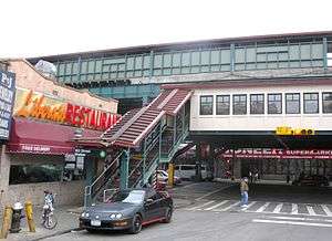
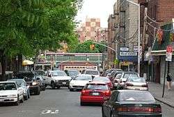
183rd Street is a local station on the elevated IRT Jerome Avenue Line of the New York City Subway. Located at the intersection of 183rd Street and Jerome Avenue in the Bronx, it is served by the 4 train at all times.
183 Street | |||||||
|---|---|---|---|---|---|---|---|
 Eastern side | |||||||
| Station statistics | |||||||
| Address | 183rd Street & Jerome Avenue Bronx, NY 10453 | ||||||
| Borough | The Bronx | ||||||
| Locale | University Heights, Fordham | ||||||
| Coordinates | 40.858324°N 73.903999°W | ||||||
| Division | A (IRT) | ||||||
| Line | IRT Jerome Avenue Line | ||||||
| Services | 4 | ||||||
| Transit connections | |||||||
| Structure | Elevated | ||||||
| Platforms | 2 side platforms | ||||||
| Tracks | 3 (2 in regular service) | ||||||
| Other information | |||||||
| Opened | June 2, 1917 | ||||||
| Station code | 383[1] | ||||||
| Opposite-direction transfer available | Yes | ||||||
| Traffic | |||||||
| Passengers (2019) | 1,779,224[2] | ||||||
| Rank | 261 out of 424[2] | ||||||
| Station succession | |||||||
| Next north | Fordham Road: 4 | ||||||
| Next south | Burnside Avenue: 4 | ||||||
| |||||||
| |||||||
| |||||||

%26groups%3D_70fdd7409628de3ca1164ef367793fcc43af887c.svg)
History
This station opened with the first part of the Jerome Avenue Line on June 2, 1917, as a shuttle service between Kingsbridge Road and 149th Street.[3][4] This was in advance of through service to the IRT Lexington Avenue Line, which began on July 17, 1918.[5]
In 1995, as a result of service reductions, the MTA was considering permanently closing the 183rd Street station, as well as two or three other stations citywide, due to its proximity to other stations.[6]
Beginning on March 5, 2007, 183rd Street and Kingsbridge Road were closed for renovation as part of a $55 million contract to renovate five stops on the IRT Jerome Avenue Line. The other three stops in the contract (Burnside Avenue, Mosholu Parkway, and Bedford Park Boulevard) were already renovated before then. This work was completed in twelve weeks on May 21, about eight weeks ahead of schedule.[7]
Station layout
| P Platform level |
Side platform | |
| Northbound local | ← | |
| Peak-direction express | No regular service | |
| Southbound local | | |
| Side platform | ||
| M | Mezzanine | Fare control, station agent, MetroCard machines |
| G | Street level | Entrances/exits |
The station has three tracks and two side platforms. The middle track is generally not used in revenue service.[8] There are old style signs painted over and covered up with new style signs, and a crossunder exists within fare control.
The 2008 artwork here is called Many Trails by Jose Ortiz. It features laminated glass windows in the mezzanine of the western station house, depicting the cultural history of University Heights.[9]
Exits
The station has a wooden mezzanine under the tracks. Outside of fare control, exits go to the northwest, southwest, and southeast corner of the staggered intersection of Jerome Avenue and 183rd Street.[10]
References
- "Station Developers' Information". Metropolitan Transportation Authority. Retrieved June 13, 2017.
- "Facts and Figures: Annual Subway Ridership 2014–2019". Metropolitan Transportation Authority. 2020. Retrieved May 26, 2020.
- "Service Begun on the Jerome Avenue Line (1917)". www.nycsubway.org. Retrieved September 6, 2016.
- "Annual report. 1916-1917". HathiTrust. Interborough Rapid Transit Company. 2013-12-12. Retrieved 2016-09-05.
- Brooklyn Daily Eagle Almanac. Brooklyn Daily Eagle. 1922. p. 372.
- Perez-Pena, Richard (February 25, 1995). "Board Votes Cuts For City Transit". The New York Times. p. 1. Archived from the original on May 18, 2020. Retrieved May 16, 2018.
- "Kingsbridge Road and 183rd Street Stations 4 Will Close for Four and One-Half Months While Under Rehabilitation". www.mta.info (Press release). Metropolitan Transportation Authority. March 5, 2007. Archived from the original on January 22, 2019. Retrieved March 9, 2017.
- Dougherty, Peter (2020). Tracks of the New York City Subway 2020 (16th ed.). Dougherty. OCLC 1056711733.
- "183rd Street - Jose Ortiz - Many Trails, 2008". web.mta.info. Metropolitan Transportation Authority. Archived from the original on August 7, 2020. Retrieved August 7, 2020.
- "183rd Street Neighborhood Map" (PDF). new.mta.info. Metropolitan Transportation Authority. April 2018. Retrieved February 28, 2019.
External links

- nycsubway.org – IRT Woodlawn Line: 183rd Street
- nycsubway.org — Many Trails Artwork by José Ortiz (2006)
- Station Reporter — 4 Train
- The Subway Nut — 183rd Street Pictures
- MTA's Arts For Transit — 183rd Street (IRT Jerome Avenue Line)\
- 183rd Street entrance from Google Maps Street View
- Platforms from Google Maps Street View
| Jerome Ave. Line |
|
|---|---|
| |