Laurel, Mississippi
Laurel is a city in and the second county seat of Jones County, Mississippi, United States. As of the 2010 census, the city had a population of 18,540.[3] It is located northeast of Ellisville, the first county seat, which contains the first county courthouse. Laurel has the second county courthouse as there are two judicial districts in Jones County. Laurel is the headquarters of the Jones County Sheriff's Department, which administers in the county.
Laurel, Mississippi | |
|---|---|
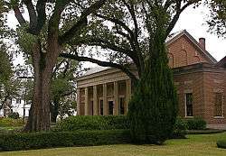 Lauren Rogers Museum of Art in Laurel | |
City logo | |
| Nickname(s): "The City Beautiful" | |
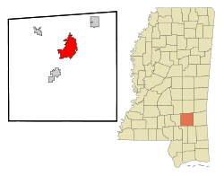 Location of Laurel in Mississippi | |
 Laurel, Mississippi Location in the contiguous United States | |
| Coordinates: 31°41′51″N 89°8′22″W | |
| Country | United States of America |
| State | Mississippi |
| County | Jones |
| Incorporated | 1882 |
| Government | |
| • Type | Mayor-Council |
| • Mayor | Johnny Magee |
| Area | |
| • Total | 16.54 sq mi (42.83 km2) |
| • Land | 16.24 sq mi (42.05 km2) |
| • Water | 0.30 sq mi (0.78 km2) |
| Elevation | 269 ft (82 m) |
| Population (2010) | |
| • Total | 18,540 |
| • Estimate (2019)[2] | 18,338 |
| • Density | 1,129.47/sq mi (436.09/km2) |
| Time zone | UTC−6 (CST) |
| • Summer (DST) | UTC−5 (CDT) |
| ZIP codes | 39440–39443 |
| Area code(s) | 601 |
| FIPS code | 28-39640 |
| GNIS feature ID | 0672321 |
| Website | www |
Laurel is the principal city of a micropolitan statistical area named for it. Major employers include Howard Industries, Sanderson Farms, Masonite International, Family Health Center, Howse Implement, Thermo-Kool, and South Central Regional Medical Center. Laurel is home to the Lauren Rogers Museum of Art, Mississippi's oldest art museum, established by the family of Lauren Eastman Rogers.
History
.jpg)
Following the 1881 construction of the New Orleans and Northeastern Railroad through the area,[4] economic development occurred rapidly. The city of Laurel was incorporated in 1882, with timber as the impetus.[5] Yellow pine forests in the region fueled the industry. The city was named for laurel thickets near the original town site.[6]
John Kamper built Laurel's first mill, which was small and primitive. On the verge of bankruptcy in 1891, Kamper sold the mill and extensive land holdings, totaling 15,000+ acres, to Clinton, Iowa, lumber barons Lauren Chase Eastman and George and Silas Gardiner. In 1893, the Eastman-Gardiner mill opened and employed the best technology and labor-saving devices of the day. This mill was followed by the Gilchrist-Fordney mill from Alpena, Michigan, in 1906, the Wausau-Southern milll from Wausau, Wisconsin, in 1911, and the Marathon mill from Memphis, Tennessee, in 1914. Following World War I, Laurel shipped more yellow pine than any other location in the entire world. The peak of lumber prosperity was reached in the 1920s, when the area's four mills were producing a total of one million board feet of lumber per day – enough laid end to end to stretch 189 miles.[7]
The economic prosperity of Laurel's timber era (1893–1937) and "timber families" created the famed Laurel Central Historic District as a byproduct.[8] The area is conisdered the largest, finest, and most intact collection of the early 20th century architecture in Mississippi and has been listed on the National Register of Historic Places since September 4, 1987,[9] for both its history and wide variety of architectural styles. Many of the homes and buildings of the district are feautred on the HGTV series Home Town (TV series). In addition to influencing a diverse architectural district, the "timber families" influenced the building of broad avenues, the design public parks, and the development of strong schools[10].
The city population grew markedly during the early 20th century because rural people were attracted to manufacturing jobs and the economic takeoff of Masonite International. Mechanization of agriculture reduced the number of farming jobs. In 1942, Howard Wash, a 45-year-old African-American man who had been convicted of murder, was dragged from jail and lynched by a mob.[11] The city reached its peak of population in 1960, and has declined about one third since then.
Geography
Laurel is in north-central Jones County, 8 miles (13 km) northeast of Ellisville, the first county seat. Interstate 59 and U.S. Route 11 pass through Laurel, both highways leading southwest 30 miles (48 km) to Hattiesburg and northeast 57 miles (92 km) to Meridian. U.S. Route 84 passes through the south side of the city, leading east 30 miles (48 km) to Waynesboro and west 27 miles (43 km) to Collins. Mississippi Highway 15 passes through the south and west sides of the city, leading northwest 24 miles (39 km) to Bay Springs and southeast 28 miles (45 km) to Richton.
According to the United States Census Bureau, Laurel has a total area of 16.5 square miles (42.8 km2), of which 15.8 square miles (40.8 km2) are land and 0.3 square miles (0.8 km2), or 1.81%, are water.[3] The city lies on a low ridge between Tallahala Creek to the east and Tallahoma Creek to the west. Tallahoma Creek joins Tallahala Creek south of Laurel, and Tallahala Creek continues south to join the Leaf River, part of the Pascagoula River watershed.
Climate
The climate in this area is characterized by hot, humid summers and generally mild to cool winters. According to the Köppen Climate Classification system, Laurel has a humid subtropical climate, abbreviated "Cfa" on climate maps.[12] The area is also prone to tornadoes. On December 28, 1954, an F3 tornado tore directly through the city, injuring 25 people.[13]
Demographics
| Historical population | |||
|---|---|---|---|
| Census | Pop. | %± | |
| 1900 | 3,193 | — | |
| 1910 | 8,465 | 165.1% | |
| 1920 | 13,037 | 54.0% | |
| 1930 | 18,017 | 38.2% | |
| 1940 | 20,598 | 14.3% | |
| 1950 | 25,038 | 21.6% | |
| 1960 | 27,889 | 11.4% | |
| 1970 | 24,145 | −13.4% | |
| 1980 | 21,897 | −9.3% | |
| 1990 | 18,827 | −14.0% | |
| 2000 | 18,393 | −2.3% | |
| 2010 | 18,540 | 0.8% | |
| Est. 2019 | 18,338 | [2] | −1.1% |
| U.S. Decennial Census[14] | |||
As of the 2010 census, Laurel had a population of 18,540. The racial and ethnic composition of the population was 61.3% African-American, 29.8% non-Hispanic white, 7.7% Hispanic or Latino, 0.7% Asian, 0.1% Native American, and 1.0% reporting two or more races.[15]
As of the census[16] of 2000, there were 18,393 people, 6,925 households, and 4,542 families residing in the city. The population density was 1,192.3 people per square mile (460.2/km2). There were 7,804 housing units at an average density of 505.9 per square mile (195.3/km2). The racial makeup of the city was 55.08% African American, 40.64% White, 0.33% Asian, 0.11% Native American, 0.01% Pacific Islander, 3.17% from other races, and 0.67% from two or more races. Hispanic or Latino of any race were 3.87% of the population.
There were 6,925 households, out of which 29.7% had children under the age of 18 living with them, 37.2% were married couples living together, 23.5% had a female householder with no husband present, and 34.4% were non-families. 30.1% of all households were made up of individuals, and 14.4% had someone living alone who was 65 years of age or older. The average household size was 2.61, and the average family size was 3.21.
In the city, the population was spread out, with 27.9% under the age of 18, 10.1% from 18 to 24, 25.4% from 25 to 44, 19.4% from 45 to 64, and 17.2% who were 65 years of age or older. The median age was 35 years. For every 100 females, there were 85.8 males. For every 100 females age 18 and over, there were 80.5 males.
The median income for a household in the city was $25,988, and the median income for a family was $30,185. Males had a median income of $27,077 versus $17,336 for females. The per capita income for the city was $15,561. 28.9% of the population and 21.4% of families were below the poverty line. 37.5% of those under the age of 18 and 19.3% of those 65 and older were living below the poverty line.
Government
City government consists of a mayor-council form. The mayor is elected at-large. Council members are elected from single-member districts.
- City officials
- Johnny Magee – Mayor
- Jason Capers – Ward 1 Councilman
- Tony Wheat – Ward 2 Councilman
- Tony Thaxton – Ward 3 Councilman
- George Carmichael – Ward 4 Councilman
- Stacy Comegys – Ward 5 Councilman
- Grace Amos – Ward 6 Councilman
- Anthony Page – Ward 7 Councilman
The United States Postal Service operates the Laurel Post Office and the Choctaw Post Office, both located in Laurel.[17][18]
The Mississippi Department of Mental Health South Mississippi State Hospital Crisis Intervention Center is in Laurel.[19]
Education
Public schools
Private schools
- Immaculate Conception School (now closed)
- Laurel Christian School
- Laurel Christian High School
- St. John's Day School (affiliated with the Episcopal Church)
Media
Infrastructure
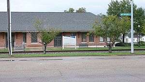
Amtrak's Crescent train connects Laurel with the cities of New York City; Philadelphia; Baltimore; Washington, D.C.; Charlotte, North Carolina; Atlanta; Birmingham, Alabama; and New Orleans. The Laurel Amtrak station is situated at 230 North Maple Street.
Hattiesburg–Laurel Regional Airport is located in an unincorporated area in Jones County near Moselle,[22] 21 miles (34 km) southwest of Laurel.
- Major highways
Notable people
- Jake Allen, professional football player
- Lance Bass, musician
- Marsha Blackburn, U.S Senator, former congresswoman from Tennessee
- Ralph Boston, Olympic champion athlete
- Lee Calhoun, Olympic champion athlete
- Jason Campbell, professional football player
- David and the Giants, Christian rock band
- Akeem Davis, professional football player
- Mary Elizabeth Ellis, actress
- Carroll Gartin, former lieutenant governor
- Ed Hinton, sportswriter
- Tess Holliday, model
- Robert Hyatt, computer scientist
- Diane Ladd, actress, raised in Meridian[23]
- Mark A. Landis, painter
- Tom Lester, television actor
- Mundell Lowe, jazz musician
- Doug Marlette, Pulitzer Prize-winning cartoonist
- Chris McDaniel, attorney and politician
- Mary Mills, professional golfer
- Kenny Payne, former professional basketball player
- Charles W. Pickering, politician and judge
- Chip Pickering, former congressman
- Stacey Pickering, State Auditor of Mississippi
- Clinton Portis, former professional football player
- Parker Posey, actress[24]
- Leontyne Price, opera singer
- Omeria McDonald Scott, state representative
- Ray Walston, actor
- Lloyd Wells, musician
In popular culture
Laurel residents Erin and Ben Napier are featured in the HGTV series Home Town, which premiered on March 21, 2017.[25] The show portrays local homes in and near Laurel as these are renovated.
In Tennessee Williams' play A Streetcar Named Desire, fictional Laurel native Blanche DuBois is known here as a "woman of loose morals" who frequents the Hotel Flamingo as told to Stanley by the merchant Kiefaber. In an argument, Blanche tells Harold Mitchell she's brought many victims into her web, and calls the hotel the Tarantula Arms rather than the Hotel Flamingo.
See also
References
- "2019 U.S. Gazetteer Files". United States Census Bureau. Retrieved July 26, 2020.
- "Population and Housing Unit Estimates". United States Census Bureau. May 24, 2020. Retrieved May 27, 2020.
- "Geographic Identifiers: 2010 Census Summary File 1 (G001): Laurel city, Mississippi". American Factfinder. U.S. Census Bureau. Archived from the original on February 13, 2020. Retrieved August 15, 2018.
- "Mississippi Railroads".
- Thames, Bill. Walking Tour of Historic Laurel Homes. Laurel, MS: Lauren Rogers Museum of Art. p. 6.
- Gannett, Henry (1905). The Origin of Certain Place Names in the United States. U.S. Government Printing Office. p. 182.
- [LRMA.org LRMA.org] Check
|url=value (help). Missing or empty|title=(help) - "A Story of Growth".
- "National Register of Historic Places".
- Lauren Rogers Museum of Art. The University Press of Mississippi. 2003. pp. ix. ISBN 1-57806-557-7.
- "Mississippi Mob Lynches a Slayer". New York Times. October 18, 1942. Retrieved October 31, 2019.
- Climate Summary for Laurel, Mississippi
- "Mississippi F3". Tornado History Projects. Storm Prediction Center. Retrieved 12 July 2020.
- United States Census Bureau. "Census of Population and Housing". Retrieved September 2, 2013.
- "U.S. Census website". Retrieved 2017-11-02.
- "U.S. Census website". United States Census Bureau. Retrieved 2008-01-31.
- "Post Office Location – LAUREL Archived 2012-08-21 at the Wayback Machine." United States Postal Service. Retrieved on November 1, 2010.
- "Post Office Location - CHOCTAW Archived 2012-08-21 at the Wayback Machine." United States Postal Service. Retrieved on November 1, 2010.
- "Contact Us Archived 2012-03-14 at the Wayback Machine." South Mississippi State Hospital. Retrieved on November 1, 2010. "SMSH Crisis Intervention Center 934 West Drive Laurel, MS 39440."
- "The Chronicle". Retrieved June 6, 2016.
- "IMPACT". Retrieved June 6, 2016.
- "Contact." Hattiesburg-Laurel Regional Airport. Retrieved on July 15, 2011. "Our Address Airport Director, 1002 Terminal Dr. Moselle, MS 39459"
- Davis Davidson, June; Putnam, Richelle (2013). Legendary Locals of Meridian. Charleston, South Carolina: Arcadia Publishing. p. 10. ISBN 146710079X.
- Schulman, Michael (July 2, 2015). "Parker Posey's Offbeat Glamour". The New York Times. Retrieved June 7, 2020.
- Shinners, Rebecca (March 10, 2017). "9 Reasons You Should Be Watching HGTV's Newest Show 'Home Town'". Country Living. Retrieved March 20, 2017.
Further reading
- Victoria E. Bynum, The Free State of Jones: Mississippi's Longest Civil War (Chapel Hill: The University of North Carolina Press, 2001, 2016)
- Alex Heard, The Eyes of Willie McGee: A Tragedy of Race, Sex and Secrets in the Jim Crow South (New York: Harper, 2011)
- Nollie W. Hickman, Mississippi Harvest: Lumbering in the Longleaf Pine Belt, 1840-1915 (Jackson: University Press of Mississippi, new edition, 2009)
- Gilbert H. Hoffman and Tony Howe, Yellow Pine Capital: The Laurel, Mississippi Story (Toot Toot Publishing Company, 2010)
- Charles Marsh, The Last Days: A Son's Story of Sin and Segregation at the Dawn of a New South (New York: Basic Books, 2000)
- Cleveland Payne, The Oak Park Story: A Cultural History, 1928-1970 (National Oak Park High School Alumni Association, 1988)
- Cleveland Payne, Laurel: A History of the Black Community, 1882-1962 (Cleveland Payne, 1990)
External links
| Wikimedia Commons has media related to Laurel, Mississippi. |
- City of Laurel official website
- Scrapbook re: Laurel, Mississippi (MUM00404), owned by the University of Mississippi.
Municipalities and communities of Jones County, Mississippi, United States | ||
|---|---|---|
| Cities | 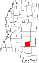 Map of Mississippi highlighting Jones County | |
| Towns | ||
| CDP | ||
| Other unincorporated communities | ||
| Indian reservation | ||
| Footnotes | ‡This populated place also has portions in an adjacent county or counties | |
| Authority control |
|
|---|