Canton, Mississippi
Canton is a city in Madison County, Mississippi, United States. The population was 13,189 at the 2010 census. It is the county seat of Madison County,[3] and situated in the northern part of the metropolitan area surrounding the state capital, Jackson.
Canton, Mississippi | |
|---|---|
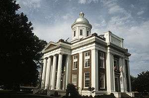 Madison County Courthouse in Canton | |
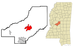 Location of Canton, Mississippi | |
 Canton, Mississippi Location in the United States | |
| Coordinates: 32°36′43″N 90°1′54″W | |
| Country | United States |
| State | Mississippi |
| County | Madison |
| Area | |
| • Total | 21.57 sq mi (55.87 km2) |
| • Land | 21.29 sq mi (55.13 km2) |
| • Water | 0.28 sq mi (0.74 km2) |
| Elevation | 233 ft (71 m) |
| Population (2010) | |
| • Total | 13,189 |
| • Estimate (2019)[2] | 12,094 |
| • Density | 568.14/sq mi (219.36/km2) |
| Time zone | UTC−6 (Central (CST)) |
| • Summer (DST) | UTC−5 (CDT) |
| ZIP code | 39046 |
| Area code(s) | 601 |
| FIPS code | 28-11100 |
| GNIS feature ID | 0691133 |
| Website | cityofcantonms |
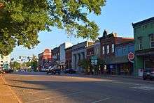
Much of Canton is on the National Register of Historic Places. The courthouse square is a historic shopping district and host to the Canton Flea Market. The picturesque Georgian courthouse is particularly notable and often appears in photographic exhibits of the South. The east side of town is a large part of the historic district with many homes.
Although not a major battle site during the Civil War, Canton was important as a rail and logistics center. Many wounded soldiers were treated in or transported through the city, and as a consequence it has a large Confederate cemetery.
The city is home to a large auto manufacturing facility owned by Nissan.
Geography
Canton is located at 32°36′43″N 90°1′54″W (32.612015, -90.031638).[4]
According to the United States Census Bureau, the city has a total area of 18.7 square miles (48 km2), of which 18.6 square miles (48 km2) is land and 0.1 square miles (0.26 km2) (0.69%) is water.
Demographics
| Historical population | |||
|---|---|---|---|
| Census | Pop. | %± | |
| 1870 | 1,963 | — | |
| 1880 | 2,131 | 8.6% | |
| 1890 | 3,404 | 59.7% | |
| 1900 | 3,464 | 1.8% | |
| 1910 | 3,929 | 13.4% | |
| 1920 | 3,252 | −17.2% | |
| 1930 | 4,725 | 45.3% | |
| 1940 | 6,011 | 27.2% | |
| 1950 | 7,048 | 17.3% | |
| 1960 | 9,707 | 37.7% | |
| 1970 | 10,503 | 8.2% | |
| 1980 | 11,116 | 5.8% | |
| 1990 | 10,062 | −9.5% | |
| 2000 | 12,911 | 28.3% | |
| 2010 | 13,189 | 2.2% | |
| Est. 2019 | 12,094 | [2] | −8.3% |
| U.S. Decennial Census[5] | |||
As of the census[6] of 2010, there were 13,189 people and 4,494 households in the city with an average household size of 2.99. The population density was 621.1 people per square mile (239.8/km2). There were 4,933 housing units. The racial makeup of the city was 19.5% White, 74.7% African American, 0.2% Native American, 0.6% Asian, 0.1% Native Hawaiian and Other Pacific Islander, and 0.8% from two or more races. Hispanic or Latino of any race were 5.5% of the population.
The age distribution was 27.5% under the age of 18 and 10.8% 65 or older. 50.8% of the population were female.
The median household income was $33,350. The per capita income for the city was $15,192. About 31.4% of the population were below the poverty line.
At the 2000 census, there were 12,911 people in 4,093 households, including 2,991 families, in the city. The population density was 694.1 people per square mile (268.0/km2). There were 4,333 housing units at an average density of 232.9 per square mile (89.9/km2). The racial makeup of the city was 18.64% White, 80.30% African American, 0.15% Native American, 0.20% Asian, 0.14% from other races, and 0.57% from two or more races. Hispanic or Latino of any race were 0.43% of the population.
Of the 4,093 households 37.1% had children under the age of 18 living with them, 32.4% were married couples living together, 34.9% had a female householder with no husband present, and 26.9% were non-families. 23.8% of households were one person and 10.9% were one person aged 65 or older. The average household size was 2.99 and the average family size was 3.55.
The age distribution was 32.3% under the age of 18, 11.2% from 18 to 24, 26.1% from 25 to 44, 18.5% from 45 to 64, and 11.9% 65 or older. The median age was 30 years. For every 100 females, there were 85.7 males. For every 100 females age 18 and over, there were 79.7 males.
The median household income was $24,237 and the median family income was $27,782. Males had a median income of $25,179 versus $20,815 for females. The per capita income for the city was $12,643. About 27.7% of families and 34.8% of the population were below the poverty line, including 49.8% of those under age 18 and 25.5% of those age 65 or over.
Notable people
- Thea Bowman (1937–1990), Catholic sister, Franciscan Sisters of Perpetual Adoration
- The Canton Spirituals, gospel recording group
- Homer Casteel (1879-1958), lieutenant governor from 1920 to 1924
- Annie Bell Robinson Devine (1912–2000), civil rights activist
- George Doherty (1920–1987), football player, Buffalo Bills
- Scott Field (1847–1931), United States Congressman from Texas
- Rowland Garrett (1950-), professional basketball player[7]
- L. C. Greenwood (1946-2013), NFL player with Pittsburgh Steelers, playing in Super Bowl IX, Super Bowl X, Super Bowl XIII and Super Bowl XIV
- Caroline Herring, folk singer
- Jim Herring (born 1938), lawyer and politician
- Elmore James (1918–1963), blues singer, slide guitarist
- Sonny Landreth (1951-), blues guitar player
- Ronnie Lester (1959-), University of Iowa basketball All-American, NBA player for Chicago Bulls and Los Angeles Lakers
- Samuel Mockbee (1944–2001), architect
- George Raymond (1943–1973), civil rights activist
- Anne Moody (1940-2015), civil rights activist, author of Coming of Age in Mississippi, based on her work with CORE
- Earl B. Dickerson (1891–1986), World War I veteran, first black graduate from University of Chicago Law School, civil rights attorney, argued Hansberry v. Lee before the United States Supreme Court, founding member of the American Legion
- Rev. Cleophus Robinson (1932-1998), gospel singer
- John Henry Rogers (1845–1911), United States Congressman from Arkansas and a federal judge, who grew up near Madison and practiced law in Canton
- William M. Walton (1832–1915), Texas Attorney General
Mississippi Blues Trail
Canton is officially on the Mississippi Blues Trail. Elmore James, a blues singer and a familiar figure in Canton, learned electronics by working in a radio repair shop on Hickory Street. Canton is rich in blues history centered on the juke joints of Hickory Street, known to locals as "The Hollow", as well as other places in Canton. A Mississippi Blues Trail historic marker was placed in Canton on Hickory Street to honor the contribution of James to the development of the blues in Mississippi. Other noted blues performers associated with Canton include Grady Champion, Little Brother Montgomery, William “Do-Boy” Diamond, Boyd Rivers and Johnny Temple. Musicians include studio guitarist Bucky Barrett and the slide guitarist Sonny Landreth. Gospel singers include the Canton Spirituals and Reverend Cleophus Robinson.[8]
In his dedication of Hickory Street, Governor Haley Barbour said,
With his innovative contributions to the electric slide guitar style, legendary Elmore
James is among the many reasons Mississippi is truly the birthplace of America’s music. Like so many others, Elmore’s work was greatly influenced by his childhood home in Canton, where he joined the ranks of musicians like B.B. King and Little Milton to play the blues on Hickory Street. Today’s blues trail marker not only recognizes the achievements of the talented Elmore James but also pays tribute
to Canton’s colorful blues heritage.[8]
Education
The city of Canton is served by the Canton Public School District. The city of Canton and Madison County are served by Canton Academy.
In popular culture
- 1974 Thieves Like Us
- 1988 Mississippi Burning
- 1996 A Time to Kill
- 1998 Walking in Mississippi
- 2000 My Dog Skip
- 2000 O Brother, Where Art Thou?
- 2001 The Ponder Heart
- 2001 Biker Zombies from Detroit
- 2008 Ballast
- 2013 As I Lay Dying
Climate
The climate in this area is characterized by hot, humid summers and generally mild to cool winters. According to the Köppen Climate Classification system, Canton has a humid subtropical climate, abbreviated "Cfa" on climate maps.[9]
| January | February | March | April | May | June | |
|---|---|---|---|---|---|---|
| Average High in °F: | 55 | 60 | 68 | 76 | 83 | 89 |
| Average Low in °F: | 33 | 36 | 43 | 50 | 59 | 67 |
| Average Precipitation in Inch: | 5.16 | 5 | 4.92 | 5.2 | 5.43 | 3.7 |
| July | August | September | October | November | December | |
|---|---|---|---|---|---|---|
| Average High in °F: | 92 | 92 | 87 | 78 | 67 | 58 |
| Average Low in °F: | 69 | 69 | 62 | 50 | 41 | 34 |
| Average Precipitation in Inch: | 3.82 | 3.58 | 3.46 | 4.02 | 4.72 | 5.59 |
References
- "2019 U.S. Gazetteer Files". United States Census Bureau. Retrieved July 26, 2020.
- "Population and Housing Unit Estimates". United States Census Bureau. May 24, 2020. Retrieved May 27, 2020.
- "Find a County". National Association of Counties. Archived from the original on 2011-05-31. Retrieved 2011-06-07.
- "US Gazetteer files: 2010, 2000, and 1990". United States Census Bureau. 2011-02-12. Retrieved 2011-04-23.
- United States Census Bureau. "Census of Population and Housing". Archived from the original on April 26, 2015. Retrieved February 5, 2014.
- "Canton (city) QuickFacts from the US Census Bureau". Quickfacts.census.gov. Archived from the original on 2015-09-05. Retrieved 2015-07-27.
- Career statistics. basketball-reference.com. Retrieved on 5 December 2015.
- "Canton To Honor Blues Legend with Mississippi Blues Trail Marker" (PDF). 209.85.215.104. Archived from the original (PDF) on 2007-10-04. Retrieved 2008-05-28.
- "Canton, Mississippi Köppen Climate Classification". Weatherbase. Retrieved 2015-07-27.
External links
- Canton Chamber of Commerce official website
- City-data.com Canton profile
- Confederate cemetery page
- History of Canton's Jewish community (from the Institute of Southern Jewish Life)
- Canton, Ms Flea Market
Municipalities and communities of Madison County, Mississippi, United States | ||
|---|---|---|
| Cities | 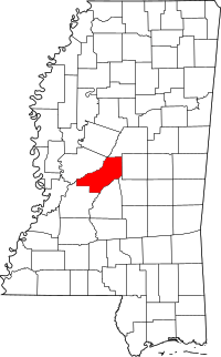 Map of Mississippi highlighting Madison County | |
| Towns | ||
| CDP | ||
| Other unincorporated communities | ||
| Ghost town | ||
| Footnotes | ‡This populated place also has portions in an adjacent county or counties | |
| Authority control |
|
|---|