Shire of Mukinbudin
The Shire of Mukinbudin is a local government area in the Wheatbelt region of Western Australia, about 80 kilometres (50 mi) north of Merredin and about 300 kilometres (186 mi) east of the state capital, Perth. The Shire covers an area of 3,437 square kilometres (1,327 sq mi), and its seat of government is the town of Mukinbudin.
| Shire of Mukinbudin Western Australia | |||||||||||||||
|---|---|---|---|---|---|---|---|---|---|---|---|---|---|---|---|
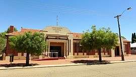 Mukinbudin Memorial Hall, 2014 | |||||||||||||||
 Location in Western Australia | |||||||||||||||
| Population | 555 (2016 census)[1] | ||||||||||||||
| • Density | 0.16147/km2 (0.4182/sq mi) | ||||||||||||||
| Postcode(s) | 6479 | ||||||||||||||
| Area | 3,437.1 km2 (1,327.1 sq mi) | ||||||||||||||
| Mayor | Gary Shadbolt | ||||||||||||||
| Council seat | Mukinbudin | ||||||||||||||
| Region | Wheatbelt | ||||||||||||||
| State electorate(s) | Central Wheatbelt | ||||||||||||||
| Federal Division(s) | Durack | ||||||||||||||
| Website | Shire of Mukinbudin | ||||||||||||||
| |||||||||||||||
History
Initially, Mukinbudin was governed by the Merredin Road District, and then from 1921 the Nungarin Road District.
The Shire of Mukinbudin originated as the Mukinbudin Road District, established with effect from 1 November 1933, having separated from Nungarin due to a growing population.[2][3] Its first election was held on 18 November 1933, and Thomas Basil Conway was elected its inaugural chairman at its first meeting.
On 1 July 1961, it became a Shire following the passage of the Local Government Act 1960, which reformed all remaining road districts into shires.[2]
Towns and localities
- Mukinbudin
- Barbalin
- Bonnie Rock
- Dandanning
- Elachbutting Rock
- Lake Brown
- Wattoning
- Wilgoyne
Population
| Year | Population |
|---|---|
| 1933 | 350 |
| 1947 | 470 |
| 1954 | 589 |
| 1961 | 707 |
| 1966 | 869 |
| 1971 | 872 |
| 1976 | 995 |
| 1981 | 884 |
| 1986 | 855 |
| 1991 | 678 |
| 1996 | 691 |
| 2001 | 648 |
| 2006 | 575 |
| 2011 | 490 |
References
- Australian Bureau of Statistics (27 June 2017). "Mukinbudin (S)". 2016 Census QuickStats. Retrieved 28 October 2019.

- "Municipality Boundary Amendments Register" (PDF). Western Australian Electoral Distribution Commission. Retrieved 11 January 2020.
- "Road Districts Act 1919-32. Nungarin Road District. Alteration of boundaries with Mount Marshall Road District and formation of Mukinbudin Road District. Order in Council (per PW 1952/26)" (PDF). Western Australia Government Gazette. 1 September 1933. p. 1933:1260.