City of South Perth
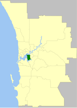
The City of South Perth is a local government area in the inner southern suburbs of the Western Australian capital city of Perth about 4 kilometres (2.5 mi) south of Perth's central business district. The City covers an area of 19.9 square kilometres (7.7 sq mi), maintains 203 kilometres (126 mi) of roads and a little over 4.3 km2 of parks and gardens, and had a population of about 42,000 at the 2016 Census. The City is the entirety of the state electoral district of South Perth. An area of Kensington joined into South Perth after the 2013 redistribution, although dwindling population growth in Victoria Park may mean that part of the City will move back.
| City of South Perth Western Australia | |||||||||||||||
|---|---|---|---|---|---|---|---|---|---|---|---|---|---|---|---|
 | |||||||||||||||
| Population |
| ||||||||||||||
| • Density | 2,121/km2 (5,492/sq mi) | ||||||||||||||
| Established | 1892 | ||||||||||||||
| Area | 19.8 km2 (7.6 sq mi) | ||||||||||||||
| Mayor | Greg Milner | ||||||||||||||
| Council seat | South Perth | ||||||||||||||
| Region | South Metropolitan Perth | ||||||||||||||
| State electorate(s) | South Perth | ||||||||||||||
| Federal Division(s) | Swan | ||||||||||||||
 | |||||||||||||||
| Website | City of South Perth | ||||||||||||||
| |||||||||||||||

The area broadly forms a peninsula, being bounded on three sides by the waters of the Swan and Canning rivers.
History
The South Perth Road District was formed on 9 June 1892 and the district became a municipality as the Municipality of South Perth on 21 February 1902. It then reverted to a road district on 1 March 1922,[3][4] but regained municipality status on 1 March 1956.[5] It was granted city status on 1 July 1959.[6]
In 2014, the WA State Government mounted a proposal for local government reform; the City of South Perth was proposed to be amalgamated with the Town of Victoria Park, together with a sizable portion of the City of Canning. A poll took place during January–February 2015, with the question: "Should the City of South Perth and the Town of Victoria Park be abolished and amalgamated to form a new local government?". The informally (non-binding) suggested name for the new entity was 'City of South Park'.
In order for the poll to prevent the amalgamation from proceeding, at least 50% of electors from either local government were required to vote, and of those, more than half needed to vote against the proposal. At the conclusion of the poll at 6.00pm on 7 February 2015, the outcome was that for South Perth, 50.83% of the City's 26,789 electors voted, with 77.75% voting against the proposal. Although only 38.02% of the Town of Victoria Park's 20,136 electors voted, of those, a clear majority (61.58%) voted against the proposal. However, with more than 50% poll returns, the City of South Perth response was sufficient to cancel the amalgamation of these local governments, and they remained as separate entities.
Wards
The City of South Perth is divided into four wards, each of whom directly elect two councillors, elected in four year cycles, in a first-past-the-post methodology. The mayor is directly elected.
- Mill Point- Ken Manolas, Mary Choy
- Moresby- Stephen Russell, Samantha Bradder
- Como- Carl Celedin, Glenn Cridland
- Manning- Blake D'Souza (deputy Mayor), Andre Brender-A-Brandis
All of these councillors are independent/unaligned. Blake D'Souza was 21 when elected in 2017.
Suburbs
The suburbs of the City of South Perth are known for being very affluent due to their proximity to the river, private schools and the CBD, all are well above the state's average. The following table contains the suburbs and their median house price, bar Karawara. House prices have dramatically increased in Como and Kensington, while being stagnant in South Perth, Manning and Salter Point, and dramatically falling in Waterford and Karawara.
| Suburb | Median house price |
|---|---|
| Como | $970,000 |
| Karawara | $599,000 |
| Kensington | $965,000 |
| Manning | $825,000 |
| Salter Point | $1,117,500 |
| South Perth | $1,252,000 |
| Waterford | $875,000 |
Education
The City of South Perth is home to numerous primary schools, and five major secondary schools.
Secondary
Primary
- Como Primary School
- Collier Primary School
- Kensington Primary School
- Manning Primary School
- St Columba's Catholic Primary School
- Saint Pius X Primary School
- South Perth Primary School
Library
The City of South Perth has two libraries with branches in Manning and South Perth.[7]
The two libraries have in excess of 70,000 items over both locations. The collection contains digital and traditional items including new and popular titles across an extensive range of books, DVDs, talking books and magazines for the whole family.
A regular events program run throughout the year is designed to educate and entertain all ages.
The City of South Perth Local History Collection is a source of knowledge, ideas, stories and memories. It is developed and managed as a community resource to inspire, educate and inform the community and visitors and to contribute to the conservation of the history and heritage of the City of South Perth.
The collection provides and preserves information about the suburbs of South Perth, Como, Kensington, Manning, Karawara and Salter Point.
Picture South Perth is an online collection of historic images dating back to the 1870s that showcases the people, places and events that have shaped the City of South Perth. It contains images from the City of South Perth's Local History Collection which have been scanned and catalogued by dedicated library staff.[8]
Population
| Year | Population |
|---|---|
| 1903 | 947 |
| 1911 | 1,197 |
| 1921 | 2,960 |
| 1933 | 8,731 |
| 1947 | 15,266 |
| 1954 | 21,214 |
| 1961 | 29,941 |
| 1966 | 32,042 |
| 1971 | 31,702 |
| 1976 | 30,388 |
| 1981 | 31,524 |
| 1986 | 32,626 |
| 1991 | 34,007 |
| 1996 | 34,819 |
| 2001 | 35,228 |
| 2006 | 38,361 |
| 2011 | 40,739 |
| 2016 | 41,989 |
Heritage listed places
As of 2020, 166 places are heritage-listed in the City of South Perth,[9] of which 20 are on the State Register of Heritage Places, among them the Old Mill, the Clontarf Aboriginal College and the Cygnet Cinema.[10]
Notes
- Australian Bureau of Statistics (27 June 2017). "South Perth (C)". 2016 Census QuickStats. Retrieved 26 November 2017.

- "3218.0 – Regional Population Growth, Australia, 2017-18". Australian Bureau of Statistics. 27 March 2019. Retrieved 31 December 2019. Estimated resident population (ERP) at 30 June 2018.
- "Road Districts Act 1919. South Perth Municipality. Proposed conversion into a road district. Notice of intention (per PW 1268/21)". Western Australia Government Gazette. 5 January 1922. p. 1922:22.
- "Road Districts Act 1919. Order in Council (per PW 1268/21)". Western Australia Government Gazette. 15 February 1922. p. 1922:421.
- "Road Districts Act 1919. South Perth Road District. Constitution as Municipality of South Perth. Order in Council (per LG 524/55)". Western Australia Government Gazette. 9 February 1956. p. 1956:567.
- "Municipality Boundary Amendments Register" (PDF). Western Australian Electoral Distribution Commission. Retrieved 11 January 2020.
- "Welcome to the City of South Perth Libraries". City of South Perth. Retrieved 17 March 2020.
- "Picture South Perth". Retrieved 17 March 2020.
- "City of South Perth Heritage Places". inherit.stateheritage.wa.gov.au. Heritage Council of Western Australia. Retrieved 19 April 2020.
- "City of South Perth State Register of Heritage Places". inherit.stateheritage.wa.gov.au. Heritage Council of Western Australia. Retrieved 19 April 2020.
References
- The History of South Perth, by F K Crowley. Rigby Limited 1962
- Peninsula City, by Cecil Florey. City of South Perth 1995