Yibin
Yibin (simplified Chinese: 宜宾; traditional Chinese: 宜賓; pinyin: Yíbīn; Wade–Giles: I-pin; Sichuanese Pinyin: nyi2bin1; Sichuanese pronunciation: [ɲi˨˩pin˥]) is a prefecture-level city in the southeastern part of Sichuan province, China, located at the junction of the Min and Yangtze Rivers. Its population was 4,471,840 inhabitants according to the 2010 census of whom 836,340 lived in the built-up area made of Cuiping District.
Yibin 宜宾市 | |
|---|---|
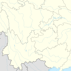
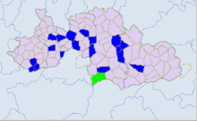
 Location of Yibin City (jurisdiction) in Sichuan | |
 Yibin Location in Southwest China 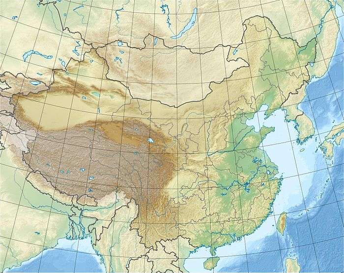 Yibin Yibin (China) | |
| Coordinates (Yibin municipal government): 28°45′07″N 104°38′35″E | |
| Country | People's Republic of China |
| Province | Sichuan |
| Municipal seat | Xuzhou District |
| Area | |
| • Prefecture-level city | 13,293.89 km2 (5,132.80 sq mi) |
| • Urban | 80 km2 (30 sq mi) |
| • Metro | 1,131 km2 (437 sq mi) |
| Elevation | 321 m (1,053 ft) |
| Population (2010 census)[2] | |
| • Prefecture-level city | 4,471,896 |
| • Density | 340/km2 (870/sq mi) |
| • Urban (2018)[3] | 595,000 |
| • Urban density | 7,400/km2 (19,000/sq mi) |
| • Metro | 836,340 |
| • Metro density | 740/km2 (1,900/sq mi) |
| Time zone | UTC+8 (China Standard) |
| Postal code | 644000 |
| Area code(s) | 0831 |
| ISO 3166 code | CN-SC-15 |
| Licence Plate Prefix | 川Q |
| Website | yibin |
History
Human habitation of Yibin dates back at least 4,000 years. Yibin was established as a county in the Han dynasty (206 BC − AD 220). Under the Ming and Qing, the town and its hinterland was known as Xuzhou Commandery (t 敘州府, s 叙州府, p Xùzhōufǔ), which was variously romanized as Suifu, Suifoo, and Suchow.[4] Its population around 1907 was estimated at 50,000.[5]
Geography and climate
Yibin is located in the southeast portion of Sichuan at the southern end of the Sichuan Basin, bordering Zhaotong (Yunnan) to the south, Luzhou to the east, Liangshan Yi Autonomous Prefecture and Leshan to the west, and Zigong to the north, and has a total area is 13,283 square kilometres (5,129 sq mi). The city ranges in latitude from 27° 50'−29° 16' N, and in longitude from 103° 36'−105° 20' E, stretching 153 km (95 mi) east-west and 150 km (93 mi) north-south.
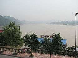
The city is located at the confluence of the Min and Yangtze Rivers. Above Yibin, the Yangtze is also known as the Jinsha River. Below Yibin, the Yangtze is known in Chinese as the Chang Jiang or "Long River."
As with the rest of the Sichuan Basin, Yibin has a monsoon-influenced humid subtropical climate (Köppen Cwa) with high humidity year-round; winters are short and mild while summers long, hot, and humid. The monthly 24-hour average temperature ranges from 7.9 °C (46.2 °F) in January to 26.9 °C (80.4 °F) in July and August; the annual mean is 18.03 °C (64.5 °F). Despite its location in the Yangtze River valley, it is still 1.5 to 2.0 °C (2.7 to 3.6 °F) cooler than Chongqing, located further downstream, in its warmest months. Frost is uncommon and the frost-free period lasts 347 days.[6] Rainfall is common year-round but is the greatest in July and August, with very little of it in the cooler months. With monthly percent possible sunshine ranging from 10% in December and January to 42% in August, the city receives only 1,018 hours of bright sunshine annually; Yibin has one of the lowest annual sunshine totals nationally, lower than even nearby Chengdu and Chongqing. Spring (March–April) tends to be sunnier and warmer in the day than autumn (October–November).
| Climate data for Yibin (1981−2010 normals) | |||||||||||||
|---|---|---|---|---|---|---|---|---|---|---|---|---|---|
| Month | Jan | Feb | Mar | Apr | May | Jun | Jul | Aug | Sep | Oct | Nov | Dec | Year |
| Record high °C (°F) | 19.6 (67.3) |
25.2 (77.4) |
32.0 (89.6) |
34.5 (94.1) |
37.1 (98.8) |
37.2 (99.0) |
38.0 (100.4) |
40.0 (104.0) |
38.3 (100.9) |
31.0 (87.8) |
26.4 (79.5) |
19.5 (67.1) |
40.0 (104.0) |
| Average high °C (°F) | 10.5 (50.9) |
13.1 (55.6) |
17.8 (64.0) |
23.4 (74.1) |
27.4 (81.3) |
29.0 (84.2) |
31.5 (88.7) |
31.3 (88.3) |
27.0 (80.6) |
21.6 (70.9) |
17.3 (63.1) |
11.8 (53.2) |
21.8 (71.2) |
| Daily mean °C (°F) | 7.9 (46.2) |
9.9 (49.8) |
13.8 (56.8) |
18.8 (65.8) |
22.7 (72.9) |
24.7 (76.5) |
26.9 (80.4) |
26.6 (79.9) |
23.1 (73.6) |
18.4 (65.1) |
14.2 (57.6) |
9.3 (48.7) |
18.0 (64.4) |
| Average low °C (°F) | 6.0 (42.8) |
7.8 (46.0) |
11.1 (52.0) |
15.5 (59.9) |
19.3 (66.7) |
21.7 (71.1) |
23.7 (74.7) |
23.4 (74.1) |
20.5 (68.9) |
16.4 (61.5) |
12.3 (54.1) |
7.5 (45.5) |
15.4 (59.8) |
| Record low °C (°F) | −1.0 (30.2) |
0.4 (32.7) |
1.1 (34.0) |
7.1 (44.8) |
10.3 (50.5) |
16.0 (60.8) |
18.5 (65.3) |
17.8 (64.0) |
14.5 (58.1) |
5.9 (42.6) |
3.4 (38.1) |
−1.4 (29.5) |
−1.4 (29.5) |
| Average precipitation mm (inches) | 17.1 (0.67) |
24.6 (0.97) |
34.2 (1.35) |
62.0 (2.44) |
101.6 (4.00) |
154.4 (6.08) |
228.7 (9.00) |
177.5 (6.99) |
107.9 (4.25) |
58.5 (2.30) |
33.5 (1.32) |
17.5 (0.69) |
1,017.5 (40.06) |
| Average precipitation days (≥ 0.1 mm) | 11.2 | 12.5 | 13.2 | 14.1 | 16.3 | 17.1 | 14.7 | 13.4 | 16.3 | 16.6 | 12.0 | 10.5 | 167.9 |
| Average relative humidity (%) | 85 | 82 | 78 | 75 | 74 | 80 | 81 | 80 | 82 | 84 | 83 | 84 | 81 |
| Mean monthly sunshine hours | 32.1 | 39.6 | 78.5 | 116.0 | 116.9 | 107.7 | 147.2 | 169.0 | 81.6 | 53.1 | 45.8 | 30.7 | 1,018.2 |
| Percent possible sunshine | 10 | 13 | 21 | 30 | 28 | 26 | 35 | 42 | 22 | 15 | 14 | 10 | 23 |
| Source 1: China Meteorological Administration (sunshine 1971–2000)[7][8] | |||||||||||||
| Source 2: Weather China (precipitation days 1971–2000)[6] | |||||||||||||
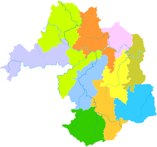
Administrative divisions
| Map | |||||
|---|---|---|---|---|---|
| Name | Hanzi | Hanyu Pinyin | Population (2010) | Area (km²) | Density (/km²) |
| Cuiping District | 翠屏区 | Cuìpíng Qū | 836,383 | 1,123 | 745 |
| Nanxi District | 南溪区 | Nánxī Qū | 335,805 | 704 | 477 |
| Xuzhou District | 叙州区 | Xùzhōu Qū | 813,057 | 3,034 | 268 |
| Jiang'an County | 江安县 | Jiāng'ān Xiàn | 399,829 | 910 | 439 |
| Changning County | 长宁县 | Chángníng Xiàn | 340,016 | 975 | 349 |
| Gao County | 高县 | Gāo Xiàn | 411,118 | 1,323 | 310 |
| Junlian County | 筠连县 | Jūnlián Xiàn | 329,056 | 1,254 | 262 |
| Gong County | 珙县 | Gǒng Xiàn | 379,798 | 1,150 | 330 |
| Xingwen County | 兴文县 | Xīngwén Xiàn | 377,162 | 1,373 | 275 |
| Pingshan County | 屏山县 | Píngshān Xiàn | 249,777 | 1,437 | 174 |
Economy
The city's industry focuses on electronics, food products, and power generation. It also produces paper, silk, and leather products. The surrounding region is rich in agricultural resources, growing rice, barley, oil seeds, sesame, and tea.
The largest employer in Yibin is Wuliangye, a company best known for Wuliangye, a brand of sorghum-based distilled spirits known as baijiu. The Wuliangye Group grew from a small company employing just 300 people in 1977 into a large company employing over 20,000 on a seven square kilometer plant. According to an August 2005 article in a securities weekly, the Wuliangye Group is 72% state owned and provides 70% of the revenues of Yibin City, a major regional center at the head of the Yangtze in southeastern Sichuan. In 2004 6,225 retired military worked for the company, out of a total work force of over 20,000. One third of top management positions are held by retired members of the military.[9] Unsuccessful efforts to diversify its business, poor transparency and a murky ownership pictures are among the company's problems today.[10] However, liquor is not the sole product of the WuLiangye Group. It also provides the specialized high-tech anti-counterfeit packaging and printing business and engineering services. Wuliangye now contributes about 60% of Yibin's GDP.
Transportation
The region's natural waterways provide transportation links with the surrounding area, and Yibin is also connected to Chongqing and Chengdu by rail and express highway. Yibin's proximity to the Yunnan and Guizhou borders also means that transportation to the provinces is available by rail and by bus.
Yibin has three bridges over the Chang Jiang section of the Yangtze and ten bridges over the Jinsha.
Yibin Airport offers flights to Beijing, Guangzhou, Guiyang, Hangzhou, Kunming, Lhasa, Sanya, Shanghai, Shenzhen, Xi'an, and Yichang.
Tourism
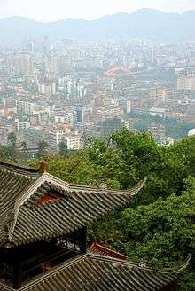
There are several hot springs near Yibin, plus many other tourist attractions. Such attractions include the Bamboo Sea in Changning County and the Xingwen Stone Forest. Yibin is also the confluence of the Min and Jinsha Rivers, which together form the Chang Jiang as the Yangtze River is known in Chinese, from Yibin to Shanghai. Cuiping Mountain Park (翠屏山公园; Cuìpíng Shān Gōngyuán), located west of the confluence of those two rivers, provides views of downtown Yibin,
Yibin in Literature
- Dragonfly Eyes by Cao Wenxuan[11]
Notes
- Cox, W (2018). Demographia World Urban Areas. 14th Annual Edition (PDF). St. Louis: Demographia. p. 22.
- "China: Administrative Division of Sìchuān / 四川省". citypopulation.de.
- Cox, W (2018). Demographia World Urban Areas. 14th Annual Edition (PDF). St. Louis: Demographia. p. 22.
- EB (1887).
- EB (1911).
- 宜宾 - 气象数据 -中国天气网. Weather China.
- 中国气象数据网 - WeatherBk Data (in Chinese). China Meteorological Administration. Retrieved 2020-04-15.
- 中国地面国际交换站气候标准值月值数据集(1971-2000年). China Meteorological Administration. Archived from the original on 2013-09-21. Retrieved 2010-05-25.
- "An Army of Production Out of Uniform: Retired Soldiers at Wuliangye", PLA Daily July 29, 2004
- "Stockholder Interests Poorly Represented, This is How Profits Slip Away," Bond Market Weekly, August 22, 2005
- Mei Jia (27 July 2016). "Readers relishing Cao Wenxuan's latest novel". China Daily. Retrieved 2018-10-07.
References

- Chisholm, Hugh, ed. (1911), , Encyclopædia Britannica, 26 (11th ed.), Cambridge University Press, p. 7.
External links
- Official city website
- Unofficial city briefing of Yibin
- Yibin City on bashu.net
- Yibin on chinaculture.org
| Authority control |
|
|---|