Yajiang County
Nyagqu or Nyachukha County (Tibetan: ཉག་ཆུ་རྫོང་།, Wylie: nyag chu rdzong, ZYPY: Nyagqu Zong , Nyagchukha, Nyagquka) or Yajiang County (Chinese: 雅江县; pinyin: Yǎjiāng Xiàn), named after Nyagchukha in Tibetan, is a county of the traditional Kham Region of eastern Tibet. It is currently under the administration of the Garzê Tibetan Autonomous Prefecture, in the west of Sichuan Province, China.

Nyagchukha County 雅江县 · ཉག་ཆུ་རྫོང་། | |
|---|---|
County | |
.png) Location of Yajiang County (red) within Garzê Prefecture (yellow) and Sichuan | |
| Coordinates: 30°01′55″N 101°00′50″E | |
| Country | People's Republic of China |
| Province | Sichuan |
| Autonomous prefecture | Garzê |
| Area | |
| • Total | 7,558 km2 (2,918 sq mi) |
| Time zone | UTC+8 (China Standard) |
Climate
| Climate data for Yajiang (1981−2010) | |||||||||||||
|---|---|---|---|---|---|---|---|---|---|---|---|---|---|
| Month | Jan | Feb | Mar | Apr | May | Jun | Jul | Aug | Sep | Oct | Nov | Dec | Year |
| Record high °C (°F) | 26.6 (79.9) |
28.1 (82.6) |
33.5 (92.3) |
32.6 (90.7) |
35.8 (96.4) |
35.7 (96.3) |
35.4 (95.7) |
35.4 (95.7) |
33.3 (91.9) |
29.6 (85.3) |
26.1 (79.0) |
23.3 (73.9) |
35.8 (96.4) |
| Average high °C (°F) | 13.6 (56.5) |
16.4 (61.5) |
19.2 (66.6) |
21.8 (71.2) |
25.2 (77.4) |
26.3 (79.3) |
26.5 (79.7) |
26.1 (79.0) |
23.9 (75.0) |
21.1 (70.0) |
16.3 (61.3) |
12.8 (55.0) |
20.8 (69.4) |
| Daily mean °C (°F) | 2.1 (35.8) |
5.8 (42.4) |
9.3 (48.7) |
12.3 (54.1) |
15.6 (60.1) |
17.4 (63.3) |
17.8 (64.0) |
17.4 (63.3) |
15.0 (59.0) |
11.3 (52.3) |
5.6 (42.1) |
1.3 (34.3) |
10.9 (51.6) |
| Average low °C (°F) | −5.5 (22.1) |
−2.5 (27.5) |
1.5 (34.7) |
5.0 (41.0) |
8.7 (47.7) |
11.9 (53.4) |
13.0 (55.4) |
12.6 (54.7) |
10.3 (50.5) |
5.5 (41.9) |
−1.0 (30.2) |
−5.4 (22.3) |
4.5 (40.1) |
| Record low °C (°F) | −13.4 (7.9) |
−9.8 (14.4) |
−6.7 (19.9) |
−1.5 (29.3) |
1.1 (34.0) |
5.1 (41.2) |
6.1 (43.0) |
5.3 (41.5) |
2.4 (36.3) |
−2.4 (27.7) |
−7.6 (18.3) |
−13.9 (7.0) |
−13.9 (7.0) |
| Average precipitation mm (inches) | 0.3 (0.01) |
1.6 (0.06) |
11.6 (0.46) |
35.0 (1.38) |
68.5 (2.70) |
165.8 (6.53) |
166.4 (6.55) |
145.7 (5.74) |
136.2 (5.36) |
42.5 (1.67) |
7.8 (0.31) |
1.7 (0.07) |
783.1 (30.84) |
| Average relative humidity (%) | 36 | 34 | 40 | 48 | 54 | 68 | 74 | 73 | 75 | 68 | 56 | 46 | 56 |
| Source: China Meteorological Data Service Center[1] | |||||||||||||
gollark: Oxford is a big historic place. Their authoritative DNS probably predates much of the commercial internet.
gollark: There are plenty of managed authoritative DNS services which I think most people use.
gollark: You seem to be confusing different kinds of DNS server.
gollark: Most registrars will give you authoritative DNS with a domain you buy from them anyway.
gollark: But presumably <@336962240848855040> means DNS servers for users, not authoritative DNS.
References
- 中国地面气候标准值月值(1981-2010) (in Chinese). China Meteorological Data Service Center. Retrieved 20 October 2018.
| County-level divisions |  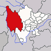 | |
|---|---|---|
| Towns and villages |
| |
| Geography |
| |
| Landmarks | ||
| Authority control |
|
|---|
This article is issued from Wikipedia. The text is licensed under Creative Commons - Attribution - Sharealike. Additional terms may apply for the media files.