U.S. Route 56
U.S. Route 56 (US 56) is an east–west United States highway that runs for approximately 640 miles (1,030 km) in the Midwestern United States. US 56's western terminus is at Interstate 25 Business (I-25 Bus.), US 412 and New Mexico State Road 21 (NM 21) in Springer, New Mexico and the highway's eastern terminus is at US 71 in Kansas City, Missouri. Much of it follows the Santa Fe Trail.
| ||||||||||
|---|---|---|---|---|---|---|---|---|---|---|
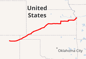
US 56 highlighted in red | ||||||||||
| Route information | ||||||||||
| Length | 640.250 mi (1,030.382 km) | |||||||||
| Existed | 1957[1]–present | |||||||||
| Major junctions | ||||||||||
| West end | ||||||||||
| ||||||||||
| East end | ||||||||||
| Location | ||||||||||
| States | New Mexico, Oklahoma, Kansas, Missouri | |||||||||
| Highway system | ||||||||||
Oklahoma State Highway System
| ||||||||||
Route description
The highway passes through New Mexico, Oklahoma, Kansas, and Missouri. The eastbound shoulder also touches a corner of Texas at a small road junction near the New Mexico/Oklahoma border.
New Mexico
US 56 runs concurrent with US 412 for its entire length in New Mexico, and are signed as such through the state. The two routes begin in Springer and head east towards Abbot, where they serve as the northern terminus of State Road 39. Continuing east, US 56/412 meet the southern terminus of NM 193 south of Farley, the northern terminus of NM 120 east of Gladstone, and the southern terminus of NM 453. US 56/412 intersect US 64 and US 87 in Clayton, New Mexico, and US 64 joins with US 56/412 in their trek northeast. The three routes serve as the southern terminus of NM 406 as they enter the Kiowa National Grassland. The three routes then cross into Oklahoma together.
Oklahoma
US-56's short path through Oklahoma consists of a diagonal slice across the western part of the Oklahoma Panhandle. US-56/64/412 enter Oklahoma near the southwest corner of the Panhandle, where they also enter Rita Blanca National Grassland. They leave the grassland near Felt. Three miles[2] (4.8 km) southwest of Boise City, US-385 joins the concurrency. The routes then enter Boise City, where they enter a traffic circle around the Cimarron County Courthouse that involves US-56, US-64, US-385, US-412, State Highway 3, and SH-325. After leaving the traffic circle, US-56 overlaps US-64, US-412, and SH-3. 1.7 miles (2.7 km) east of the courthouse, US-56 meets US-287 at an interchange. US-56/64/412/SH-3 continue northeast for 6 miles (9.7 km),[2] where US-56 splits to travel northeast on its own.
The route parallels the Cimarron Valley Railroad for the remainder of its time in Oklahoma. Keyes is the next town on US-56, and it also serves as the northern terminus of SH-171 where the two highways intersect. US-56 crosses into Texas County east of Sturgis. Just before crossing the Kansas line, US-56 meets the north end of SH-95. US-56 then enters Kansas on the east edge of Elkhart.
Kansas
US-56 enters the state at the Kansas/Oklahoma border near Elkhart. It weaves its way across the state from southwest to northeast, passing through such towns as Dodge City, Great Bend, McPherson, Council Grove, and Baldwin City. It joins with I-35/US-50 east of Gardner, and goes northeast with I-35 into the Kansas City Metro Area. It exits the state as part of Shawnee Mission Parkway in Merriam.
Missouri
For one mile (1.6 km) in Kansas City's Country Club Plaza, Route 56 follows the noted boulevard Ward Parkway along with 47th St through the Country Club Plaza. The route ends at an intersection with U.S. Route 71. It also includes Blue Parkway and Swope Parkway at certain points.
History
In the early 1950s, towns along what was then the K-45 corridor, connecting Ellsworth, Kansas to the Oklahoma state line at Elkhart, formed the Mid-Continent Diagonal Highway Association[3] to push for a new highway from Springer, New Mexico (on US 85) northeast across the Oklahoma Panhandle, along K-45, and continuing to Manitowoc, Wisconsin on Lake Michigan.[4] By mid-1954, it was being promoted as U.S. Route 55 between the Great Lakes and the Southwestern United States.[5] The first submissions to the American Association of State Highway Officials (AASHO) to establish the route were made in 1954; all placed the northeast end at Manitowoc, Wisconsin (absorbing US 151 from Cedar Rapids, Iowa), while they varied on whether the southwest end was to be at Albuquerque, New Mexico or Nogales, Arizona.[6] The first route considered in northeast Kansas was via US 40 from Ellsworth to Topeka and K-4 and US 59 via Atchison to St. Joseph, Missouri.[7] A revised route adopted in March 1955, due to AASHO objections to the original route, which traveled concurrently with other U.S. Highways for over half of its length, followed K-14, K-18, US 24, K-63, K-16, and US 59 via Lincoln and Manhattan.[8][9] In July, the US 50-N Association proposed a plan that would have eliminated US 50N by routing US 55 along most of its length, from Larned east to Baldwin Junction, and then along US 59 to Lawrence and K-10 to Kansas City; towns on US 50N west of Larned, which would have been bypassed, led a successful fight against this.[10][11]
However, in September of that year, the Kansas Highway Commission accepted that plan, taking US 55 east to Kansas City.[12] On June 27, 1956, the AASHO Route Numbering Committee considered this refined plan for US 55, between Springer, New Mexico and Kansas City, Missouri, with a short US 155 along the remaining portion of US 50N from Larned west to Garden City. The committee approved the request, but since the proposed route was more east–west than north–south, it changed it to an even number – US 56 – and the spur to US 156.[6]
US 56 originally took a different route between Boise City, Oklahoma and Elkhart, Kansas. The original route followed US 64 east to an intersection south of Eva. It then split off to the north towards Elkhart.[13] By 1961, the section north of US 64 had been overlaid with SH-95.[14] The following year, US 56 was rerouted over SH-114, bringing it to its current diagonal path across the Oklahoma Panhandle.[15] The old alignment is still on the Oklahoma highway system as the north half of SH-95.
Major intersections
| State | County | Location | mi | km | Destinations | Notes | ||
|---|---|---|---|---|---|---|---|---|
| New Mexico | Colfax | Springer | 0.000 | 0.000 | Western termini of US 56/US 412; western end of US 412 overlap; highway continues as NM 21 | |||
| Abbott | 19.719 | 31.735 | ||||||
| | 31.690 | 51.000 | ||||||
| Union | | 46.688 | 75.137 | |||||
| | 54.040 | 86.969 | ||||||
| Clayton | 82.400 | 132.610 | ||||||
| 82.530 | 132.819 | Western end of US 64 overlap | ||||||
| | 85.890 | 138.227 | ||||||
| 94.172 0.00 | 151.555 0.00 | New Mexico–Oklahoma line | ||||||
| Oklahoma | Cimarron | | 28.49 | 45.85 | Western end of US-385 overlap | |||
| Boise City | 32.31 | 52.00 | Traffic circle, eastern end of US-385 overlap, western end of SH-3 overlap, eastern terminus of SH-325 | |||||
| | 34.03 | 54.77 | Interchange; US-287 exit 21 | |||||
| | 40.09 | 64.52 | Eastern end of US-64/US-412/SH-3 overlap | |||||
| Keyes | 48.54 | 78.12 | ||||||
| Texas | | 71.46 | 115.00 | |||||
| 71.68 0.000 | 115.36 0.000 | Oklahoma–Kansas line | ||||||
| Kansas | Morton | Elkhart | 2.366 | 3.808 | ||||
| Rolla | 17.746 | 28.559 | Western end of K-51 overlap | |||||
| Stevens | | 25.994 | 41.833 | Western end of K-25 overlap | ||||
| Hugoton | 33.629 | 54.121 | Eastern end of K-51 overlap | |||||
| 35.775 | 57.574 | Eastern end of K-25 overlap | ||||||
| Seward |
No major junctions | |||||||
| Haskell | Satanta | 61.813 | 99.478 | Western end of K-190 overlap | ||||
| 62.893 | 101.216 | Eastern end of K-190 overlap | ||||||
| Sublette | 69.316 | 111.553 | ||||||
| Gray | | 87.201 | 140.336 | |||||
| | 100.191 | 161.242 | ||||||
| Ford | Dodge City | 116.209 | 187.020 | Western end of US-400 overlap | ||||
| 119.752 | 192.722 | Western end of US-283 overlap | ||||||
| 123.182 | 198.242 | Eastern end of US-400 overlap | ||||||
| 126.894 | 204.216 | Western end of US-50 overlap | ||||||
| Wright | 128.630 | 207.010 | Eastern end of US-283 overlap | |||||
| Edwards | Kinsley | 156.790 | 252.329 | Eastern end of US-50 overlap | ||||
| 116.838 | 188.033 | Western end of US-183 overlap | ||||||
| Pawnee | | 165.995 | 267.143 | Eastern end of US-183 overlap | ||||
| Larned | 182.397 | 293.540 | ||||||
| 183.810 | 295.814 | Western end of K-156 overlap; former US-156 west | ||||||
| Barton | Great Bend | 204.229 | 328.675 | Western end of K-96 overlap | ||||
| 206.006 | 331.535 | |||||||
| | 209.801 | 337.642 | Eastern end of K-156 overlap; former US-156 east | |||||
| Rice | Lyons | 236.876 | 381.215 | Eastern end of K-96 overlap | ||||
| McPherson | McPherson | 265.669 | 427.553 | Former US-81 | ||||
| 266.667 | 429.159 | Western end of US-81 Bus. overlap | ||||||
| 269.185 | 433.211 | Eastern end of US-81 Bus. overlap; I-135 exit 60 | ||||||
| Marion | | 285.158 | 458.917 | Western end of K-15 overlap | ||||
| Lehigh | 286.642 | 461.306 | ||||||
| Hillsboro | 291.156 | 468.570 | Eastern end of K-15 overlap | |||||
| Marion | 301.399 | 485.055 | ||||||
| | 305.390 | 491.478 | Western end of US-77 overlap | |||||
| Dickinson | Herington | 324.997 | 523.032 | |||||
| 327.060 | 526.352 | Eastern end of US-77 overlap | ||||||
| Morris | | 337.304 | 542.838 | |||||
| Council Grove | 351.155– 351.323 | 565.129– 565.400 | ||||||
| Lyon | Admire | 372.731 | 599.852 | |||||
| | 376.162 | 605.374 | Tolls at entrance to, and exit from, Kansas Turnpike; Kansas Tpke. exit 147 | |||||
| Miller | 378.469 | 609.087 | ||||||
| Osage | | 386.959 | 622.750 | Wye intersection; western end of K-31 overlap | ||||
| Burlingame | 393.732 | 633.650 | Eastern end of K-31 overlap | |||||
| | 383.775 | 617.626 | ||||||
| Douglas | Baldwin City | 426.126 | 685.783 | |||||
| | 436.919 | 703.153 | ||||||
| Johnson | Gardner | New Century AirCenter | Interchange | |||||
| 448.458 | 721.723 | Western end of I-35 and US-50 overlaps; I-35 exit 210 | ||||||
| Overlap with I-35 | ||||||||
| Merriam | 466.340 | 750.501 | Eastern end of I-35 overlap; I-35 exit 228B | |||||
| Overland Park–Shawnee line | 467.710 | 752.706 | Eastern end of US-69 overlap; interchange | |||||
| Mission–Fairway line | Roe Avenue / Johnson Drive | Interchange; westbound exit and eastbound entrance | ||||||
| Westwood–Mission Woods line | 471.201 | 758.325 | Eastern end of US-169 overlap | |||||
| 471.450 0.000 | 758.725 0.000 | Kansas–Missouri line | ||||||
| Missouri | Jackson | Kansas City | 2.948 | 4.744 | Interchange; eastern terminus; road continues as Swope Parkway | |||
1.000 mi = 1.609 km; 1.000 km = 0.621 mi
| ||||||||
See also
Related U.S. Routes
- U.S. Route 156 (decommissioned)
References
- Official Road Map of New Mexico (ZIP File) (Map). 1:1,267,200. Cartography by Louis Hesch. Santa Fe: New Mexico State Highway Department. 1957. §§ 9B,8B. Retrieved August 3, 2019 – via University of New Mexico RGIS.
- Official State Map (PDF) (Map) (Centennial ed.). Oklahoma Department of Transportation. 2007.
- Atchison Daily Globe, December 17, 1953
- Great Bend Daily Tribune, October 1, 1953
- Great Bend Daily Tribune, New Mexico Okays US-55 Road Proposal, June 2, 1954
- Oklahoma Department of Transportation, Chronological History Documentation: US 56 (correspondence between ODOT, AASHO, and other DOTs)
- Great Bend Daily Tribune, January 6, 1955
- Great Bend Daily Tribune, New US-55 Route Approved Here, March 20, 1955
- Atchison Daily Globe, March 20, 1955
- Great Bend Daily Tribune, July 26, 1955
- Great Bend Daily Tribune, July 29, 1955
- Great Bend Daily Tribune, Highway Boosters Here Oppose New US-55 Plan, September 16, 1955
- Oklahoma's Highways 1957 (PDF) (Map). Oklahoma Department of Highways. Retrieved January 19, 2008.
- Oklahoma 1961 Road Map (PDF) (Map). Oklahoma Department of Highways. Retrieved January 19, 2008.
- Oklahoma 1962 (PDF) (Map). Oklahoma Department of Highways. Retrieved January 19, 2008.
External links
- Endpoints of U.S. Highway 56
- Kansas Highway Maps: Current, Historic, KDOT
Routes in italics are no longer a part of the system. Highlighted routes are considered main routes of the system. |
| Browse numbered routes | ||||
|---|---|---|---|---|
| ← | NM | NM 56 | ||
| ← | OK | SH-56 | ||
| ← | KS | K-57 | ||
| ← | MO | I-57 | ||