K-177 (Kansas highway)
K-177 is a 102.871-mile-long (165.555 km) south–north state highway in central Kansas. It runs from U.S. Route 54 (US-54) near El Dorado northward to US-24 in Manhattan, passing through the Flint Hills. It is part of the Flint Hills Scenic Byway and the Prairie Parkway.[2]
| ||||
|---|---|---|---|---|
%26groups%3D_3ab05f3757aabe0aa4ef3bc4075f2c875e836bdf.svg)
K-177 highlighted in red | ||||
| Route information | ||||
| Maintained by KDOT | ||||
| Length | 102.871 mi[1] (165.555 km) | |||
| Tourist routes | ||||
| Major junctions | ||||
| South end | ||||
| North end | ||||
| Location | ||||
| Counties | Butler, Chase, Morris, Wabaunsee, Geary, Riley | |||
| Highway system | ||||
| ||||

Route description
.jpg)
From its beginnings east of El Dorado, K-177 heads northward to provide access to El Dorado Lake. It then approaches the Kansas Turnpike and runs parallel to it before having a junction with it (exit 92). It then passes through Matfield Green and Bazaar before reaching Cottonwood Falls, Strong City, and US-50.
Flint Hills Scenic Byway is a portion of K-177 located in the Flint Hills region of the state, stretching from Interstate 35 at Cassoday in the south to US-56 at Council Grove in the north. Along the byway there are rolling hills and some of the only tallgrass prairie left in North America. It is a National Scenic Byway.
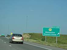
North of Strong City, K-177 passes through the Tallgrass Prairie National Preserve. In Council Grove, it meets US-56. It has a brief concurrency with K-4 near Alta Vista before having an interchange (exit 313) with Interstate 70. Nine miles north of I-70, it ends at US-24 in Manhattan.
From I-70 to US-24, K-177 is named the Coach Bill Snyder Highway, in honor of the long-time Kansas State University football coach.[3]
K-177 is two lanes from US-54 to I-70 and a four-lane expressway from I-70 to US-24.
History
K-177 was signed as K-13 until 1965.[4] It previously ended at US-77 before El Dorado Lake was completed.[4]
Approved in early 2019, it was approved to reconstruct 24 miles (39 km) of K-177, from four miles (6.4 km) north of Council Grove to I-70. The project will increase the width of the roadway from 26 feet (7.9 m) to 40 feet (12 m) and will move certain sections to new alignments. The $25 million project is expected to be completed in 2020.[5]
In September 2019, KDOT approved several projects along K-177 in Chase County. Three bridges will be replaced, including a $2.3 million bridge connecting K-177 to US-50 just west of Strong City, a $1.9 million bridge over Fox Creek, a $1.3 million bridge over a Fox Creek drainage area and a $436,000 bridge over Bloody Creek southeast of Cottonwood Falls.[6]
Junction list
| County | Location | mi[1] | km | Destinations | Notes |
|---|---|---|---|---|---|
| Butler | | 0.000 | 0.000 | Southern terminus | |
| Cassoday | 18.753 | 30.180 | I-35/KTA exit 92 | ||
| Chase | Strong City | 46.423 | 74.711 | Interchange | |
| Morris | Council Grove | 65.662 | 105.673 | Western end of US-56 concurrency | |
| 65.830 | 105.943 | Eastern end of US-56 concurrency | |||
| Morris–Wabaunsee county line | | 78.275 | 125.971 | Southern end of K-4 concurrency | |
| | 79.275 | 127.581 | Northern end of K-4 concurrency | ||
| Geary | | 94.249 | 151.679 | I-70 exit 313 | |
| Riley | | 101.979 | 164.119 | Southern end of K-18 concurrency | |
| Manhattan | 102.559 | 165.053 | Pierre Street west | Interchange; northbound left exit and southbound left entrance | |
| Northern end of K-18 concurrency | |||||
| 102.871 | 165.555 | Northern terminus; road continues as US 24 west (Tuttle Creek Boulevard) | |||
1.000 mi = 1.609 km; 1.000 km = 0.621 mi
| |||||
References
- Kansas Department of Transportation. "Pavement Management Information System". Retrieved 2010-05-13.
- Kennedy, Richie. "Kansas Highways Routelog". Archived from the original on 2007-08-11. Retrieved 2007-03-14.
- Oct 2006 KDOT employee newsletter
- Kansas Department of Transportation: Historic State Maps
- "Kansas State Legislature - Delayed T-WORKS Modernization & Expansion Projects". Kansas State Legislature. 2019. Retrieved 20 April 2020.
- Chuck Samples (September 9, 2019). "K-177 to have three significant bridge replacement projects in Chase County, including one at US-50 junction". kvoe.com. Retrieved 20 April 2020.