Typhoon Nesat (2017)
Typhoon Nesat, known in the Philippines as Typhoon Gorio, was a strong tropical cyclone that impacted Taiwan and Fujian, China. It was the ninth named storm and the second typhoon of the annual typhoon season. After consolidating slowly for several days, Tropical Storm Nesat developed east of the Philippines on July 25. While experiencing favorable environmental conditions such as very warm sea surface temperatures, Nesat strengthened into a typhoon and reached its peak intensity on July 28. On July 29, the typhoon made landfall near the Taiwanese city of Yilan, before weakening to a severe tropical storm and making landfall again near Fuqing on China's east coast late the same day. Moving into July 30, Nesat continued to weaken under the effects of land interaction.
| Typhoon (JMA scale) | |
|---|---|
| Category 2 typhoon (SSHWS) | |
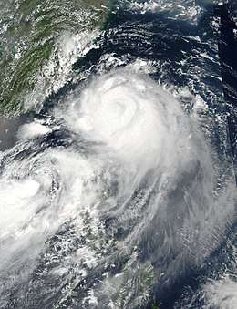
 Typhoon Nesat approaching Taiwan at peak intensity on July 29, with Tropical Storm Haitang to its southwest | |
| Formed | July 25, 2017 |
| Dissipated | July 30, 2017 |
| Highest winds | 10-minute sustained: 150 km/h (90 mph) 1-minute sustained: 155 km/h (100 mph) |
| Lowest pressure | 960 hPa (mbar); 28.35 inHg |
| Fatalities | 3 total |
| Damage | $282.3 million (2017 USD) |
| Areas affected | Philippines, Ryukyu Islands, Taiwan, East China, Thailand |
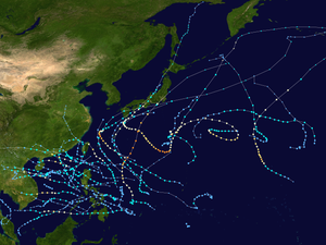
| Part of the 2017 Pacific typhoon season | |
Meteorological history

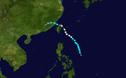
A tropical disturbance accompanied by a broad low-pressure area formed near Palau on July 21; its circulation and associated convection remained elongated and disorganized for the next few days.[1][2] However, on July 25, the system began to consolidate, with formative convective banding wrapping into its low-level circulation center. As such, the Japan Meteorological Agency (JMA) upgraded it to a tropical depression, and the Joint Typhoon Warning Center (JTWC) issued a Tropical Cyclone Formation Alert shortly after.[3] Meanwhile, PAGASA also stated that the system had intensified into Tropical Depression Gorio.[4] Despite having a partially exposed LLCC, the JTWC also upgraded the system to a tropical depression early on July 26, after scatterometer data and the Dvorak technique revealed sufficient organization.[5] Soon after that, the JMA upgraded the system to a tropical storm and assigned it the international name Nesat while it was located about 600 km (375 mi) east-northeast to Naga, Philippines.[6] Later on July 26, JTWC followed suit and upgraded it to a tropical storm.[7]
Tropical Storm Nesat began to intensify slowly as it tracked generally northwestward along the western edge of an extension of the subtropical ridge centered to the east, aided by a weak anticyclone over the system and a vigorous equatorward outflow channel. By the morning on July 27, the JMA upgraded Nesat to a severe tropical storm.[8][9] Amid favorable conditions with weakening vertical wind shear and sea surface temperatures of over 31 °C (88 °F) in the area southeast of Taiwan, Nesat intensified into a typhoon at around 06:00 UTC on July 28.[10] Despite a new tropical depression to the west of the typhoon restricting outflow to the west,[11] Nesat strengthened further to reach its peak intensity at around 18:00 UTC, with the central pressure at 960 hPa (28.35 inHg) and ten-minute maximum sustained winds at 150 km/h (90 mph). As Nesat continued to approach Taiwan, animated radar imageries from the Central Weather Bureau (CWB) of Taiwan and microwave imagery depicted a developing eye with strong spiral banding.[12][13]
Maintaining its peak intensity, Typhoon Nesat made its first landfall over Su'ao, Yilan County in Taiwan at 11:10 UTC and re-emerged over the Taiwan Strait from Zhunan, Miaoli County at 14:30 UTC.[14][15] The mountainous terrain of Taiwan caused Nesat's convective structure to rapidly decay while cloud tops quickly warmed. At around 21:00 UTC, the JMA downgraded it to a severe tropical storm, and the JTWC downgraded it to a tropical storm.[16][17] At around 22:00 UTC on July 29, Nesat made its second landfall over Fuqing, Fujian, China.[18] About five hours later, the JTWC issued their final warning on Nesat.[19]
Preparations and impact
Philippines
Even though Typhoon Nesat (Gorio) remained well away from the country, the system enhanced the southwest monsoon which resulted in torrential rains and extreme flooding. Damages reportedly reached ₱247.58 million (US$4.9 million).[20]
Taiwan
Before Nesat made landfall, more than 10,000 people, largely from the southern parts of Taiwan, were evacuated and 1,612 were moved into shelters. A total of 145 international flights were cancelled. As Nesat moved inland, it produced strong winds that downed power lines, leaving nearly half a million households without electricity. A total of 111 people were injured when the typhoon hit.[21][22] Agricultural losses across the country were estimated at $176 million NT (US$5.83 million). Nearly 200 schools across Taiwan were damaged, accounting for about $17.8 million NT (US$588,000) of losses.[23] Together with Tropical Storm Haitang a few days later, a total of $280.5 million NT (US$9.26 million) worth of damage was inflicted on the country.[24]
China
Some 70,000 people have been evacuated and dozens of trains and flights suspended in Fuzhou, according to Fujian's water resources department.
See also
References
- "Significant Tropical Weather Advisory for the Western and South Pacific Oceans/220600Z-230600Z Jul 2017". Joint Typhoon Warning Center. July 22, 2017. Archived from the original on July 26, 2017. Retrieved July 30, 2017.
- "Marine Weather Warning for GMDSS Metarea XI 2017-07-21T00:00:00Z". WIS Portal – GISC Tokyo. Japan Meteorological Agency. July 21, 2017. Retrieved July 30, 2017.
- "Marine Weather Warning for GMDSS Metarea XI 2017-07-25T06:00:00Z". WIS Portal – GISC Tokyo. Japan Meteorological Agency. July 25, 2017. Retrieved July 30, 2017.
- "Severe Weather Bulletin No. 01 re Tropical Depression "Gorio"" (PDF). National Disaster Risk Reduction and Management Council. July 25, 2017. Archived from the original (PDF) on July 29, 2017. Retrieved July 30, 2017.
- "Prognostic Reasoning for Tropical Depression 11W (Eleven) Warning Nr 01". Joint Typhoon Warning Center. July 26, 2017. Archived from the original on July 30, 2017. Retrieved July 30, 2017.
- "WTPQ23 RJTD 260300 RSMC Tropical Cyclone Advisory". Japan Meteorological Agency. July 26, 2017. Archived from the original on July 26, 2017. Retrieved July 30, 2017.
- "Prognostic Reasoning for Tropical Depression 11W (Eleven) Warning Nr 02". Joint Typhoon Warning Center. July 26, 2017. Archived from the original on July 30, 2017. Retrieved July 30, 2017.
- "WTPQ23 RJTD 270000 RSMC Tropical Cyclone Advisory". Japan Meteorological Agency. July 27, 2017. Archived from the original on July 28, 2017. Retrieved July 30, 2017.
- "Prognostic Reasoning for Tropical Storm 11W (Nesat) Warning Nr 05". Joint Typhoon Warning Center. July 27, 2017. Archived from the original on July 30, 2017. Retrieved July 30, 2017.
- "WTPQ23 RJTD 280600 RSMC Tropical Cyclone Advisory". Japan Meteorological Agency. July 28, 2017. Archived from the original on July 28, 2017. Retrieved July 30, 2017.
- "Prognostic Reasoning for Typhoon 11W (Nesat) Warning Nr 10". Joint Typhoon Warning Center. July 28, 2017. Archived from the original on July 30, 2017. Retrieved July 30, 2017.
- "WTPQ23 RJTD 281800 RSMC Tropical Cyclone Advisory". Japan Meteorological Agency. July 28, 2017. Archived from the original on July 29, 2017. Retrieved July 30, 2017.
- "Prognostic Reasoning for Typhoon 11W (Nesat) Warning Nr 13". Joint Typhoon Warning Center. July 29, 2017. Archived from the original on July 30, 2017. Retrieved July 30, 2017.
- "中度颱風,編號第9號(國際命名:NESAT,中文譯名:尼莎)海上陸上颱風警報第13報" (in Chinese). Central Weather Bureau. July 29, 2017. Archived from the original on July 29, 2017. Retrieved July 30, 2017.
- "中度颱風,編號第9號(國際命名:NESAT,中文譯名:尼莎)海上陸上颱風警報第14報" (in Chinese). Central Weather Bureau. July 29, 2017. Archived from the original on July 29, 2017. Retrieved July 30, 2017.
- "WTPQ23 RJTD 292100 RSMC Tropical Cyclone Advisory". Japan Meteorological Agency. July 29, 2017. Archived from the original on July 30, 2017. Retrieved July 30, 2017.
- "Prognostic Reasoning for Tropical Storm 11W (Nesat) Warning Nr 16". Joint Typhoon Warning Center. July 29, 2017. Archived from the original on July 30, 2017. Retrieved July 30, 2017.
- "台风"纳沙"和"海棠"将影响江南华南等地福建浙江江西等地有强降水" (in Chinese). National Meteorological Center of CMA. July 30, 2017. Archived from the original on July 30, 2017. Retrieved July 30, 2017.
- "Tropical Storm 11W (Nesat) Warning Nr 017". Joint Typhoon Warning Center. July 30, 2017. Archived from the original on July 30, 2017. Retrieved July 30, 2017.
- "Sitrep No.10 re Southwest Monsoon Enhanced by TY "GORIO"" (pdf). NDRRMC. August 3, 2017. Retrieved August 3, 2017.
- "Typhoon injures 111 in Taiwan as another storm approaches". ABC News. July 30, 2017.
- "Storms deal damage, injure 111". The Taipei Times. July 31, 2017.
- http://focustaiwan.tw/news/asoc/201707280020.aspx
- "Agricultural losses from typhoon creep up to NT$300 million". Focus Taiwan News Channel. August 1, 2017.
External links
| Wikimedia Commons has media related to Typhoon Nesat (2017). |
- JMA General Information of Typhoon Nesat (1709) from Digital Typhoon
- JMA Tropical Cyclone Information of Typhoon Nesat (1709)
- 11W.NESAT from the U.S. Naval Research Laboratory
