Tropical Storm Pakhar (2017)
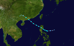
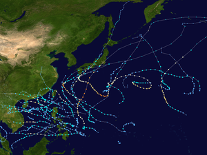
Tropical Storm Pakhar, known in the Philippines as Tropical Storm Jolina, was a strong tropical storm that impacted South China during late August 2017. This storm followed Typhoon Hato which affected the area a few days prior. Pakhar was the fourteenth named storm of the Pacific typhoon season. Pakhar developed from a tropical depression to the east of Luzon during August 24, and intensified into a tropical storm later that day. Pakhar made landfall over in Aurora on August 25. Pakhar gradually intensified and peaked as a severe tropical storm by August 27, making landfall over Taishan, Jiangmen in Southern China.
| Severe tropical storm (JMA scale) | |
|---|---|
| Tropical storm (SSHWS) | |
.png) Tropical Storm Pakhar making landfall on August 27 | |
| Formed | August 24, 2017 |
| Dissipated | August 28, 2017 |
| Highest winds | 10-minute sustained: 100 km/h (65 mph) 1-minute sustained: 110 km/h (70 mph) |
| Lowest pressure | 985 hPa (mbar); 29.09 inHg |
| Fatalities | 13 total |
| Damage | $115.3 million (2017 USD) |
| Areas affected | Philippines, South China, Vietnam, Thailand |
| Part of the 2017 Pacific typhoon season | |
Meteorological history

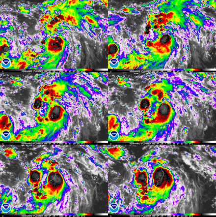
On August 23, the Joint Typhoon Warning Center (JTWC) started to monitor a tropical disturbance that had developed about 895 km (556 mi) to the north of the island of Palau.[1] The next day, the Japan Meteorological Agency (JMA) classified the system as a weak tropical depression,[2] while the JTWC issued a Tropical Cyclone Formation Alert (TCFA).[3] Six hours after the TCFA, the JMA began issuing advisories on the depression after they have determined that the system contained winds of 55 km/h (35 mph).[4] By 15:00 UTC of the same day, the JTWC had upgraded the system to a tropical depression, assigning the numerical designation 16W.[5] Three hours later, the JMA tracked that 16W had already strengthened into a tropical storm, giving 16W the name Pakhar.[6] Around the same time, the PAGASA began issuing advisories under the local name Jolina.[7] After it was depicted by satellite imagery that there were deep convection obscuring its low-level circulation center (LLCC), the JTWC had upgraded the system to a tropical storm.[8]
By August 25, Pakhar slightly intensified after convective banding wrapping to its LLCC was depicted by imagery. Pakhar was also located in a very favorable environment such as low wind shear along with warm sea-surface temperatures of 31 °C (87.8 °F).[9] Pakhar slightly intensified after a burst of deep convection developed just prior of making landfall over in Luzon in the province of Aurora.[10][11] However, due to land reaction from the archipelago and the inclusion of a weakened convective structure, Pakhar weakened to minimal tropical storm intensity.[12]
After emerging to the South China Sea on August 26, Pakhar began to re-intensify as the storm entered in an area of a much lower amount of wind shear.[13] However six hours later, Pakhar maintained its intensity after its LLCC became exposed and its deep convective banding became fragmented.[14] By 18:00 UTC of the same day, the JMA upgraded Pakhar's intensity as a severe tropical storm,[15] despite its central convection remaining disorganized.[16] The PAGASA also stated that the storm had already exited their area of responsibility, issuing its final bulletin on Pakhar.[17] By 00:00 UTC of August 27, Pakhar reached its maximum intensity of 100 km/h (65 mph) with a minimum barometric pressure of 985 hPa while making landfall over in South China in the city of Taishan.[18] The JTWC assessed Pakhar's maximum intensity slightly higher with winds of 110 km/h (70 mph), however.[1] Three hours later, the JTWC issued their final advisory.[19] By 06:00 UTC, Pakhar began to rapidly weaken as the JMA downgraded Pakhar to a tropical storm.[20] The JMA tracked the system until 18:00 UTC of the same day when it fully dissipated.[21]
Preparations and Impact
Philippines

Tropical Storm Pakhar was locally named as Jolina within the country by PAGASA. As soon as the PAGASA began issuing advisories on the storm, Tropical Cyclone Warning Signal#1 was raised over most of Cagayan Valley and northern Aurora during August 24.[22] Tropical Cyclone Warning Signal #2 was also raised in the same areas with the inclusion of the Cordillera Administrative Region while Signal #1 was extended to the Ilocos Region and Bicol Region.[23] By August 25, a total of 16 provinces were placed in a warning as they were located within a 100 km (60 mi) radius of the storm.[24] Classes were suspended for all levels over in Albay, Bicol due to possible threats of flooding and landslides on August 25.[25] The government also announced the suspension of classes for August 26 over in Metro Manila and some parts of Central Luzon and Calabarzon.[26] The province of Ilocos Sur declared the suspension of work in all public and private services that same day.[27]
The Office of the Civil Defense warned Cagayan Valley residents of severe flooding in the low-lying areas in Isabela and Cagayan provinces.[28] Kennon Road in Benguet were closed due to the threat of landslides. Hiking, trekking, and caving were suspended over in mountainous areas in the Mountain Province.[29] Heavy rainfall from Pakhar caused the Magat Dam to overflow, which also submerged several bridges over in Isabela.[30] A total of 11 flights to Hong Kong and South China from Ninoy Aquino International Airport were canceled due to the storm.[31] Eight domestic flights were canceled throughout August 25.[27]
According to the National Disaster Risk Reduction and Management Council, 3,397 people were affected by the storm with 17 reports of flooding.[27] The cities of Balatan, San Fernando and Ifugao suffered power outages throughout the storm. Overall, no casualties have been reported ad damages were relatively minor.[27] Recorded damages in Aurora province have reached PH₱41.27 million (US$808 thousand).[32]
Hong Kong, Macau and South China
Still recovering from the aftermath of Typhoon Hato which impacted the area four days earlier, the Macao Meteorological and Geophysical Bureau issued a Tropical cyclone signal No. 8 for Macau late on August 26, as the storm approached.[33] An orange typhoon warning was also raised over in the provinces of Shenzhen and Guangzhou while red warning was raised in Zhuhai.[34][35] A total of 206 flights were cancelled and another 471 delayed while 44 flights had to divert,[36] including roughly 300 flights in total in Hong Kong were either cancelled or delayed, with 30 others diverted.[37] A total of 206 flights were cancelled and another 471 delayed while 44 flights had to divert,[38] including roughly 300 flights in total in Hong Kong were either cancelled or delayed, with 30 others diverted.[37] There were 13 reports of flooding and 159 fallen trees over in Hong Kong.[39] Two people were stranded in Kowloon Peak and moreover, the Government Flying Service deployed a Challenger 604 fixed-wing plane to locate 11 crew members waiting in the control room of a sinking Hong Tai 176 vessel.[40]
While making landfall, Pakhar brought winds of about 90 km/h (55 mph) with gusts of up to 150 km/h (93 mph) over in Hong Kong, along with nearly 150 mm (6 in) of rainfall.[41] A total of 9,000 emergency repairers, 97 emergency generator vehicles and 1,691 generators are in place in Guangxi and the Yangtze River flood control headquarters dispatched personnel for the provinces of Sichuan and Yunnan.[42]
Around 1:00 p.m local time, both the Macau and Hong Kong Observatory lowered their signal to a Tropical cyclone signal No. 3, but it wasn't until 10:10 p.m local time when all signals were down. The Home Affairs Department of Hong Kong opened 27 temporary shelters while the China Ferry Terminal in Tsim Sha Tsui was closed temporarily. Ferry services across the Pearl River Delta were also suspended.[43] Part of the Stonecutters Bridge was closed due to strong winds which made vehicles taller than 1.5 metres and motorcycles barred from using the bridge.[43] Moreover, 51 people sought medical treatment in public hospitals and 231 people have sought refuge in shelters.[37]
An orange typhoon warning was also raised over in the provinces of Shenzhen and Guangzhou while red warning was raised in Zhuhai.[44][45] Furthermore, Hainan had a total of 24,124 fishing boats put into harbor.[46] All of the water bus service was paused in Pearl River Delta.[47] The city of Taishan had recorded gusts of 119 km/h (74 mph). Pakhar drenched the Pearl River Delta region with the city of Shenzhen having total rainfall of 162 mm (6.4 in). The National Meteorological Center of China had forecast torrential rain over in the South China provinces from August 27–28, especially Guangdong and Guangxi could reach up to 1800 mm (71 in) of rain.[48] A total of 9,000 emergency repairers, 97 emergency generator vehicles and 1,691 generators are in place in Guangxi and the Yangtze River flood control headquarters dispatched personnel for the provinces of Sichuan and Yunnan.[49]
A total of 83,000 people were affected by the storm, along with 14,000 people in which were evacuated over in the four main affected regions of Guandong, Guangxi, Guizhou and Yunnan.[50] One person died from a traffic incident while 62 were injured,[43] while an additional two were confirmed hours later.[51] Overall, 12 people were killed by Pakhar,[50] and damages have reached CN¥760 million (US$114.4 million).[52]
Elsewhere
The remnants of Pakhar caused heavy rainfall in Bắc Kạn Province, Vietnam. It cost 2 billion₫ (US$88,000) in damage.[53] Pakhar brought extreme rainfall over in some parts of Thailand despite it not having any direct impact. Due to the torrential rain, a major reservoir in Sakon Nakhon had to be discharged, leading to a flood watch being issued in the northern parts of the country on August 28. The Nam Pung Dam also carried about 170 million cubic meters of water, about 3% over its usual holding capacity.[54]
See also
References
- "Tropical Disturbance". noaa.gov. Retrieved 14 September 2017.
- "Tropical Depression". webcitation.org. Archived from the original on 24 August 2017. Retrieved 14 September 2017.CS1 maint: BOT: original-url status unknown (link)
- "TCFA". webcitation.org. Archived from the original on 24 August 2017. Retrieved 14 September 2017.CS1 maint: BOT: original-url status unknown (link)
- "RSMC Tropical Cyclone Advisory TD". Japan Meteorological Agency. 24 August 2017. Archived from the original on 25 August 2017.CS1 maint: BOT: original-url status unknown (link)
- "Tropical Depression 16W (Sixteen) Warning Nr 001". Joint Typhoon Warning Center. 24 August 2017. Archived from the original on 24 August 2017.CS1 maint: BOT: original-url status unknown (link)
- "RSMC Tropical Cyclone Advisory TS 1714 PAKHAR (1714) UPGRADED FROM TD". Japan Meteorological Agency. 24 August 2017. Archived from the original on 25 August 2017.CS1 maint: BOT: original-url status unknown (link)
- "3 Luzon areas under Signal No. 1 due to 'Jolina'". Sun Star. 24 August 2017.
- "Tropical Storm 16W (Pakhar) Warning Nr 002". Joint Typhoon Warning Center. 24 August 2017. Archived from the original on 25 August 2017.CS1 maint: BOT: original-url status unknown (link)
- "Prognostic Reasoning for Tropical Storm 16W (Pakhar) Warning Nr 003". Joint Typhoon Warning Center. 25 August 2017. Archived from the original on 25 August 2017.CS1 maint: BOT: original-url status unknown (link)
- "Tropical Storm Jolina makes landfall in Aurora". Rappler. 25 August 2017.
- "Prognostic Reasoning for Tropical Storm 16W (Pakhar) Warning Nr 005". Joint Typhoon Warning Center. 25 August 2017. Archived from the original on 25 August 2017.CS1 maint: BOT: original-url status unknown (link)
- "Prognostic Reasoning for Tropical Storm 16W (Pakhar) Warning Nr 006". Joint Typhoon Warning Center. 25 August 2017. Archived from the original on 26 August 2017.CS1 maint: BOT: original-url status unknown (link)
- "Prognostic Reasoning for Tropical Storm 16W (Pakhar) Warning Nr 007". Joint Typhoon Warning Center. 26 August 2017. Archived from the original on 26 August 2017.CS1 maint: BOT: original-url status unknown (link)
- "Prognostic Reasoning for Tropical Storm 16W (Pakhar) Warning Nr 008". Joint Typhoon Warning Center. 26 August 2017. Archived from the original on 26 August 2017.CS1 maint: BOT: original-url status unknown (link)
- "RSMC Tropical Cyclone Advisory STS 1714 PAKHAR (1714) UPGRADED FROM TS". Japan Meteorological Agency. 26 August 2017. Archived from the original on 27 August 2017.CS1 maint: BOT: original-url status unknown (link)
- "Prognostic Reasoning for Tropical Storm 16W (Pakhar) Warning Nr 010". Joint Typhoon Warning Center. 26 August 2017. Archived from the original on 27 August 2017.CS1 maint: BOT: original-url status unknown (link)
- "'Jolina' picks up speed, seen to exit PAR by Saturday night". Inquirer. 26 August 2017.
- "RSMC Tropical Cyclone Advisory STS 1714 PAKHAR (1714)". Japan Meteorological Agency. 27 August 2017. Archived from the original on 27 August 2017.CS1 maint: BOT: original-url status unknown (link)
- "Tropical Storm 16W (Pakhar) Warning Nr 011". Joint Typhoon Warning Center. 27 August 2017. Archived from the original on 27 August 2017.CS1 maint: BOT: original-url status unknown (link)
- "RSMC Tropical Cyclone Advisory TS 1714 PAKHAR (1714) DOWNGRADED FROM STS". Japan Meteorological Agency. 27 August 2017. Archived from the original on 27 August 2017.CS1 maint: BOT: original-url status unknown (link)
- "RSMC Tropical Cyclone Advisory TD 1714 PAKHAR (1714) DOWNGRADED FROM TS". Japan Meteorological Agency. 27 August 2017. Archived from the original on 27 August 2017.CS1 maint: BOT: original-url status unknown (link)
- "Severe Weather Bulletin No.01 re Tropical Depression JOLINA" (PDF). NDRRMC. Retrieved 24 August 2017.
- "Severe Weather Bulletin No.03 re Tropical Storm JOLINA" (PDF). NDRRMC. Retrieved 25 August 2017.
- "Provinces under red alert due to Tropical Storm Jolina". Rappler. 25 August 2017.
- "Classes suspended in 4 Albay towns as 'Jolina' dumps heavy rains". Inquirer. 25 August 2017.
- "List: Class suspensions for August 26". Philstar. 26 August 2017.
- "SitRep No.05 re Preparedness Measures for Tropical Storm JOLINA (I.N. PAKHAR)" (PDF). NDRRMC. 27 August 2017.
- "Cagayan Valley braces for tropical storm 'Jolina'". The Manila Times. 25 August 2017.
- "Kennon Road closed due to Tropical Storm Jolina". Rappler. 25 August 2017.
- "Jolina causes Magat dam overflow, swamps Isabela bridges". GMA News. 28 August 2017.
- "11 flights from Philippines to HK, China cancelled due to storm". Asia One. 28 August 2017.
- "Storm Pakhar displaces 929 families in Philippines". Anadolu Agency. 27 August 2017.
- "Macao hoists Signal No. 8 to face Typhoon Pakhar". Xinhua. 27 August 2017.
- "Typhoon Warnings Issued as South China Braces for Pakhar". Thatsmags. 27 August 2017.
- "珠海发布台风红色预警:6小时内平均风力可达12级以上". 27 August 2017.
- "Still recovering from a typhoon, Hong Kong and Macau hit by tropical cyclone Pakhar". The National. 27 August 2017.
- "Typhoon Pakhar Weakens After Making Landfall in Southern China". Bloomberg. 27 August 2017.
- "Still recovering from a typhoon, Hong Kong and Macau hit by tropical cyclone Pakhar". The National. 27 August 2017.
- "Storm Pakhar hits Hong Kong and Macau days after deadly Hato". Reuters. 27 August 2017.
- "Rescuers in Hong Kong save 11 at sea and two on mountain as Tropical Storm Pakhar batters city". South China Morning Post. 27 August 2017.
- "2nd storm in a week batters southern China". MRT. 27 August 2017.
- "Storm strikes just days after deadly typhoon hit cities". Shanghai Daily. 28 August 2017.
- "Storm warning downgraded to No 1 as Hong Kong escapes worst of Severe Tropical Storm Pakhar". SCMP. 28 August 2017.
- "Typhoon Warnings Issued as South China Braces for Pakhar". Thatsmags. 27 August 2017.
- "珠海发布台风红色预警:6小时内平均风力可达12级以上". 27 August 2017.
- "Typhoon Pakhar makes landfall in China". India Today. 27 August 2017.
- "受台风帕卡影响 广州水上巴士全部停航". 27 August 2017.
- "China issues alert for Typhoon Pakhar". Xinhua. 27 August 2017.
- "Storm strikes just days after deadly typhoon hit cities". Shanghai Daily. 28 August 2017.
- "台风"帕卡"致粤桂黔滇4省份12人死亡" (in Chinese). 中华人民共和国民政部. 31 August 2017.
- "Typhoon Pakhar kills 3 in South China". Xinhua. 29 August 2017.
- http://www.typhooncommittee.org/12IWS/docs/Members/China20171026_final.pdf
- "Effect of Rain". backantv.vn. Retrieved 15 September 2017.
- "Storm Pakhar to bring rain to North, Northeast". Bangkok Post. 28 August 2017.
External links
| Wikimedia Commons has media related to Severe Tropical Storm Pakhar (2017). |
- JMA General Information of Severe Tropical Storm Pakhar (1714) from Digital Typhoon
- 16W.PAKHAR from the U.S. Naval Research Laboratory
- South China Morning Post Topic : Typhoon Hato
