Transport in Madagascar
Paved and unpaved roadways, as well as railways, provide the main forms of transport in Madagascar. In 2010, Madagascar had approximately 7,617 km (4,730 mi) of paved roads, 854 km (530 mi) of railways and 432 km (270 mi) of navigable waterways.[1]
Railways

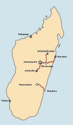
There are several rail lines and stations in Madagascar. Antananarivo is connected to Toamasina, Ambatondrazaka and Antsirabe by rail, and another rail line connects Fianarantsoa to Manakara.
The northern railway (TCE) is concessioned to Madarail. The southern line, Fianarantsoa-Côte-Est railway (FCE), is a parastatal line.
Highways
The majority of roads in Madagascar are unpaved, with many becoming impassable in the rainy season. Largely paved national routes connect the six largest regional towns to Antananarivo, with minor paved and unpaved routes providing access to other population centers in each district.[2]
Routes Nationales (National roads)
| Number | Length (km) | Runs through | Condition |
|---|---|---|---|
| N1 | 149 | Antananarivo – Analavory – Tsiroanomandidy – Belobaka | parts are paved |
| N1b | 94 | Analavory – Babetville – Tsiroanomandidy | |
| N2 | 367 | Antananarivo – Toamasina | paved, good condition |
| N3 | 91 | Antananarivo – Anjozorobe – Lake Alaotra | paved |
| N3a | 180 | Lake Alaotra – Andilamena | paved, good condition |
| N3b | 106 | Sambava – Andapa | paved, good condition |
| N4 | Antananarivo – Mahajanga | paved | |
| N5 | 402 | Toamasina – Maroantsetra | first 160 paved; remaining, unpaved in poor condition |
| N5a | 406 | Ambilobe – Antalaha | unpaved between Ambilobe – Vohemar;
remaining paved, in good condition |
| N6 | 727 | Antsiranana – Ambondromamy | paved |
| N7 | Antananarivo – Tulear | paved, good condition | |
| N8 | 198 | Morondava – Belo-sur-Tsiribihina – Bekopaka | unpaved |
| N8a | 119 | Maintirano – Antsalova | |
| N9 | 382 | Tuléar – Bevoay – Manja – Mandabe | unpaved |
| N10 | 512 | Andranovory – Beloha – Ambovombe | unpaved |
| N11 | 103 | Mananjary – Nosy Varika | unpaved, poor condition |
| N11a | 125 | junction RN2 – Vatomandry
Ilaka Atsinana – Mahanoro |
partly paved |
| N12 | 300 | Irondro – Manakara – Farafangana – Vangaindrano | paved, partly in bad condition |
| N12a | 238 | Tôlanaro (Fort Dauphin) – Manantenina – Vangaindrano | unpaved, bad condition |
| N13 | 506 | Ihosy – Ambovombe – Tôlanaro (Fort Dauphin) | unpaved between Ihosy – Ambovombe, paved but bad condition from Ambovombe – Tôlanaro (Fort Dauphin) |
| N22 | 38 | Fenoarivo Atsinanana (Fénérive) – Vavatenina | mostly paved |
| N24 | 45 | Mananjary – Vohilava, Mananjary | unpaved |
| N25 | 161 | Ambohimahasoa – Irondro – Mananjary | partly paved, partly unpaved in poor condition |
| N27 | 275 | Ihosy – Ivohibe – Farafangana | largely unpaved |
| N31 | 129 | Antsohihy – Bealanana | mostly paved |
| N32 | 200 | Antsohihy – Mandritsara | unpaved |
| N33 | 340 | Ambatondrazaka – Ambondromamy | unpaved |
| N34 | 368 | Antsirabe – Miandrivazo – Malaimbandy | Antsirabe – Miandrivazo: paved; Miandrivazo – Malaimbandy: unpaved |
| N35 | 460 | Ambositra – Malaimbandy – Morondava | paved, in poor condition |
| N41 | Ambositra – Fandriana | ||
| N43 | Analavory – Ampefy – Soavinandriana – Ambohibary – Sambaina | paved | |
| N44 | Moramanga – Ambatondrazaka – Imerimandroso | partly paved | |
| N55 | 78 | Bevoay – Morombe | unpaved |
Waterways
The relatively short rivers of Madagascar are typically of local importance only; isolated streams and small portions of Lakandranon' Ampangalana (Canal des Pangalanes) are navigated by pirogue. Coastal inter-city transport routes are found along the west coast.
Ports and harbors
The most important seaport in Madagascar is located on the east coast at Toamasina. Ports at Toliara, Mahajanga, and Antsiranana are significantly less used because of their remoteness.[2] The island's newest port at Port d'Ehola, constructed in 2008 and privately managed by Rio Tinto, will come under state control upon completion of the company's mining project near Tôlanaro around 2038.[3] The country's principal cargo port is Toamasina Autonomous Port.[4]
Airports
The main international airport in Madagascar is Ivato International Airport in Antananarivo. Air Madagascar services the island's many small regional airports, which offer the only practical means of access to many of the more remote regions during rainy season road washouts.[2] There are 29 airports with paved runways, and 104 airports with unpaved runways.
See also
Notes
- Bradt (2011), p. 2.
- Metz, Helen Chapin (1994). "Library of Congress Country Studies: Madagascar". Archived from the original on 9 November 2005. Retrieved 1 February 2011.
- "About QMM". Rio Tinto. 2009. Archived from the original on 13 February 2012. Retrieved 19 September 2012.
- Madagascar International Container Terminal Services, About us Archived 2009-01-26 at the Wayback Machine
References
- Bradt, Hilary (2011). Madagascar, 10th Ed.: The Bradt Travel Guide. London: Bradt Travel Guides. ISBN 978-1-84162-341-2.
External links
- Helicopter Antananarivo - Helicopter charter service in Antananarivo
- Madagascar Helicopter - Helicopter transfer service
- Report about Madarail and TCE (Tananarive-Côtes Est) by photojournalist Rijasolo