Route nationale 13 (Madagascar)
Route nationale 13 (RN 13) is a primary highway in Madagascar of 493 km, running from Ihosy to Tolagnaro (Fort-Dauphin). It crosses the regions of Ihorombe, Androy and Anosy.
| Route nationale 13 | |
|---|---|
| Highway system | |
| List of roads in Madagascar |
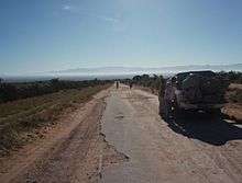
Route nationale 13 near Berenty
It is completely unpaved between Ihosy and Ambovombe, paved but in bad shape between Ambovombe and Tolagnaro.[1]
It was planned to pave the section between Ihosy and Ambovombe from 2009 on with funding by the European Union[2] but this project was stopped due to the political take over of Andry Rajoelina and the 2009 Malagasy political crisis.[3]
Selected locations on route
(north to south)
- Ihosy - intersection with Route nationale 7
- Betroka
- (crossing Mangoky River)
- Kalambatritra Reserve at 55 km east
- Ianabinda
- Beraketa
- Antanimora Atsimo
- Ambovombe - intersection with Route nationale 10
- Amboasary Sud
- Mandrare River crossing
- Berenty Reserve
- Lake Anony
- Italy Bay
- Ranopiso
- Manambaro
- Tolagnaro (Fort-Dauphin) - continues North as Route nationale 12a
gollark: <@331320482047721472> do you
gollark: ddg! "psi-7"
gollark: ddg! initiate protocol psi-44
gollark: ddg! "JHLT" "Tells you how late Joe's homework is."
gollark: ddg! jlht "joe's" homework lateness timer
See also
- List of Roads in Madagascar
- Transport in Madagascar
References
- Dilag Tours - Routes Nationales
- www?expressmada.com - Réféction de la Route nationale n° 13 - 10 July 2007
- (in French) L'Express de Madagascar - La RN 13 prend un enjeu politique Archived 1 May 2013 at the Wayback Machine - 25 April 2013
This article is issued from Wikipedia. The text is licensed under Creative Commons - Attribution - Sharealike. Additional terms may apply for the media files.