Bekopaka
Bekopaka is a town and commune (Malagasy: kaominina) in western Madagascar. It belongs to the district of Antsalova, which is a part of Melaky RegionǏ. The population of the commune was estimated to be approximately 9,000 in 2001 commune census.[2]
Bekopaka | |
|---|---|
 Bekopaka Location in Madagascar | |
| Coordinates: 19°1′S 44°51′E | |
| Country | |
| Region | Melaky |
| District | Antsalova |
| Elevation | 334 m (1,096 ft) |
| Population (2001)[2] | |
| • Total | 9,000 |
| Time zone | UTC3 (EAT) |
Bekopaka is served by a local airport, and primary and junior level secondary education are available in town. The most important crop is rice, while other important products are bananas, maize and cassava.[2]
References and notes
- Estimated based on DEM data from Shuttle Radar Topography Mission
- "ILO census data". Cornell University. 2002. Retrieved 2008-03-04.
| Antsalova | 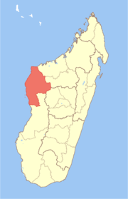 | |
|---|---|---|
| Ambatomainty |
| |
| Besalampy | ||
| Maintirano | ||
| Morafenobe | ||
gollark: Oh, GPL stuff.
gollark: Source of *what*?
gollark: SY69JL
gollark: Many, many things.
gollark: Citation: everything is root.
This article is issued from Wikipedia. The text is licensed under Creative Commons - Attribution - Sharealike. Additional terms may apply for the media files.