Miandrivazo
Miandrivazo is a town and commune (Malagasy: kaominina) in Madagascar. It is situated at the Mahajilo River and belongs to the district of Miandrivazo, which is a part of Menabe Region. The population of the commune was estimated to be approximately 108,000 in 2001 commune census.[2]
Miandrivazo | |
|---|---|
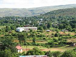 | |
 Miandrivazo Location in Madagascar | |
| Coordinates: 19°33′20″S 45°27′3″E | |
| Country | |
| Region | Menabe |
| District | Miandrivazo |
| Elevation | 100 m (300 ft) |
| Population (2001)[2] | |
| • Total | 108,000 |
| Time zone | UTC3 (EAT) |
Miandrivazo is served by a local airport. In addition to primary schooling the town offers secondary education at both junior and senior levels. The town has a permanent court and hospital.[2]
The majority 80% of the population of the commune are farmers, while an additional 5% receives their livelihood from raising livestock. The most important crop is rice, while other important products are beans and maize. Services provide employment for 10% of the population. Additionally fishing employs 5% of the population.[2]
References and notes
- Estimated based on DEM data from Shuttle Radar Topography Mission
- "ILO census data". Cornell University. 2002. Retrieved 2008-03-11.
| Belo sur Tsiribihina |  | |
|---|---|---|
| Mahabo | ||
| Manja | ||
| Miandrivazo | ||
| Morondava | ||