Thái Bình
Thái Bình City (![]()
Thái Bình (City) Thành phố Thái Bình | |
|---|---|
| Thái Bình City | |
 Thái Bình (City) Location of Thái Bình in Vietnam | |
| Coordinates: 20°26′46″N 106°20′32″E | |
| Country | |
| Province | Thái Bình |
| Established | 29 April 2004 |
| Area | |
| • Total | 67.7135 km2 (26.1443 sq mi) |
| Population (2013) | |
| • Total | 268,167 |
| • Density | 3,961/km2 (10,260/sq mi) |
History
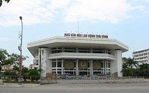
The Workers' House of Culture
In the 10th century, the area was the domain of the Tran clan, which rose in power to become the Trần Dynasty of Vietnam in the early 13th century. The town Thái Bình (Sino-Vietnamese: 太平) developed near the Keo Pagoda constructed in 1061.
Before the prime minister declared it a city in June 2004, Thai Binh was officially a town. The city is the center of economics and culture in its province. Thai Binh Medical College is considered one of the highest quality medical colleges in Vietnam.[1]
Climate
| Climate data for Thái Bình | |||||||||||||
|---|---|---|---|---|---|---|---|---|---|---|---|---|---|
| Month | Jan | Feb | Mar | Apr | May | Jun | Jul | Aug | Sep | Oct | Nov | Dec | Year |
| Record high °C (°F) | 31.7 (89.1) |
31.9 (89.4) |
35.9 (96.6) |
37.0 (98.6) |
38.0 (100.4) |
39.0 (102.2) |
39.2 (102.6) |
37.2 (99.0) |
36.3 (97.3) |
33.9 (93.0) |
32.5 (90.5) |
30.1 (86.2) |
39.2 (102.6) |
| Average high °C (°F) | 19.3 (66.7) |
19.3 (66.7) |
21.9 (71.4) |
26.2 (79.2) |
30.5 (86.9) |
32.2 (90.0) |
32.6 (90.7) |
31.6 (88.9) |
30.3 (86.5) |
28.1 (82.6) |
25.0 (77.0) |
21.6 (70.9) |
26.5 (79.7) |
| Daily mean °C (°F) | 16.3 (61.3) |
16.9 (62.4) |
19.4 (66.9) |
23.3 (73.9) |
26.9 (80.4) |
28.6 (83.5) |
29.2 (84.6) |
28.4 (83.1) |
27.0 (80.6) |
24.4 (75.9) |
21.1 (70.0) |
17.8 (64.0) |
23.3 (73.9) |
| Average low °C (°F) | 14.2 (57.6) |
15.3 (59.5) |
17.8 (64.0) |
21.4 (70.5) |
24.5 (76.1) |
26.0 (78.8) |
26.7 (80.1) |
25.9 (78.6) |
24.6 (76.3) |
21.7 (71.1) |
18.3 (64.9) |
15.0 (59.0) |
20.9 (69.6) |
| Record low °C (°F) | 4.1 (39.4) |
5.5 (41.9) |
6.7 (44.1) |
12.8 (55.0) |
16.9 (62.4) |
19.4 (66.9) |
21.9 (71.4) |
21.6 (70.9) |
16.5 (61.7) |
11.6 (52.9) |
9.1 (48.4) |
4.4 (39.9) |
4.1 (39.4) |
| Average precipitation mm (inches) | 26 (1.0) |
27 (1.1) |
49 (1.9) |
84 (3.3) |
164 (6.5) |
201 (7.9) |
207 (8.1) |
298 (11.7) |
318 (12.5) |
224 (8.8) |
65 (2.6) |
25 (1.0) |
1,686 (66.4) |
| Average precipitation days | 9.4 | 13.4 | 17.0 | 13.4 | 12.5 | 13.0 | 12.1 | 15.5 | 15.3 | 12.4 | 7.9 | 6.1 | 147.9 |
| Average relative humidity (%) | 85.4 | 88.7 | 90.7 | 90.0 | 86.1 | 83.6 | 82.4 | 86.3 | 86.8 | 84.9 | 82.3 | 82.8 | 85.8 |
| Mean monthly sunshine hours | 73 | 39 | 42 | 92 | 194 | 187 | 212 | 177 | 180 | 175 | 142 | 126 | 1,639 |
| Source: Vietnam Institute for Building Science and Technology[2] | |||||||||||||
gollark: New esolang: <;>[#']))-=\\███ℵ′′′\*\`\`\`⊆⌘☢.
gollark: I can see that people have recognized my esolang as the epitome of language design and are too dazzled by its splendor to even be able to formulate any relevant thoughts.
gollark: It's like brainf\*\*\*\*k but with `;` for "append memory cell under the pointer to string accumulator", `'` for "using value of string accumulator as target URL, send HTTP GET request", and `/` for "read one character of resulting page to memory cell under the pointer".
gollark: Announcing my new esolang, Brainet.
gollark: I'm afraid that as you are deleted you can no longer send messages.
References
- BMJ: British Medical Journal - Volume 313, Issues 7061-7072 1996- Page 1115 "Data from Thai Binh reproductive health survey, April 1992, on 347 mothers delivering for first time from April 1987 to ... We thank the participating women in this survey, our colleagues at Thai Binh Medical College, and the staff of Centre for ..."
- "Vietnam Building Code Natural Physical & Climatic Data for Construction" (PDF). Vietnam Institute for Building Science and Technology. Archived from the original (PDF) on 22 July 2018. Retrieved 31 July 2018.
External Links
| Wikimedia Commons has media related to Thai Binh City. |
| ||||||||||||||||||||||||||||||||||||||
This article is issued from Wikipedia. The text is licensed under Creative Commons - Attribution - Sharealike. Additional terms may apply for the media files.