Squankum, New Jersey
Squankum (Lenape for "place of evil ghosts" or "place where evil spirits dwell"[2]) is an unincorporated community located within Howell Township in Monmouth County, New Jersey, United States.[3][4][5][6] The name Squankum was used for a town in Gloucester County, which was changed to present day Williamstown (see note above), due to postal regulations that prohibited the two towns from having the same name.
Squankum, New Jersey | |
|---|---|
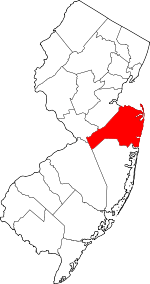
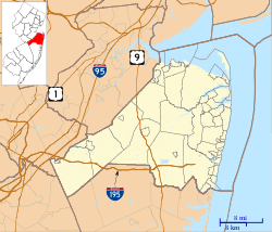 Squankum, New Jersey Location of Squankum in Monmouth County Inset: Location of county within the state of New Jersey  Squankum, New Jersey Squankum, New Jersey (New Jersey)  Squankum, New Jersey Squankum, New Jersey (the United States) | |
| Coordinates: 40°09′58″N 74°09′14″W | |
| Country | |
| State | |
| County | Monmouth |
| Township | Howell |
| Elevation | 43 ft (13 m) |
| Time zone | UTC-5 (Eastern (EST)) |
| • Summer (DST) | UTC-4 (EDT) |
| GNIS feature ID | 880830[1] |
Description
Located within Howell Township, Squankum is near Allaire State Park. Major county roads in Squankum include 524 and 547. Interstate 195 provides access to Squankum, along with its neighboring town, Farmingdale, via exit 31B.
gollark: You can already have that, on more task-specific models.
gollark: It's not a sphere.
gollark: Here's SCP-055, if anyone wanted to know.
gollark: This is waterfalls with bees, or something.
gollark: Say, how would you like to be converted into antielectron neutrinos?
References
- "Squankum". Geographic Names Information System. United States Geological Survey.
- Roncace, Kelly. "Williamstown traces name back to Lenni-Lenape", Gloucester County Times, March 4, 2012. Accessed November 25, 2017. "The Native Americans referred to the area as Squankum — meaning 'place of evil ghosts' or 'place where evil spirits dwell.' It is thought that the “evil ghosts” might refer to the many mosquitos found in the area."
- Gordon, Thomas Francis (1834). "A Gazetteer of the State of New Jersey: Comprehending a General View of Its Physical and Moral Condition, Together with a Topographical and Statistical Account of Its Counties, Towns, Villages, Canals, Rail Roads, &c., Accompanied by a Map".
- Tova Navarra, Tova Navarra (1996), Howell and Farmingdale: A Social and Cultural History, Arcadia Publishing, ISBN 9780738563763
- "NJDOT Graphic Information System Maps Middlesex" (PDF). New Jersey Department of Transportation. Retrieved March 29, 2020.
- Locality Search, State of New Jersey. Accessed March 4, 2015.
This article is issued from Wikipedia. The text is licensed under Creative Commons - Attribution - Sharealike. Additional terms may apply for the media files.