Robinsville, New Jersey
Robinsville is an unincorporated community located within Upper Freehold Township in Monmouth County, New Jersey, United States.[2] Located in the northeastern corner of the township near Millstone Township and Roosevelt, the area is located wholly in the Assunpink Wildlife Management Area, the area consists of forest and some farmland that was in existence prior to the creation of the WMA in the 1970s.[3][4]
Robinsville, New Jersey | |
|---|---|
.jpg) | |
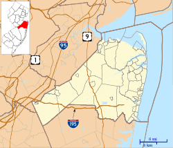 Robinsville, New Jersey Location of Robinsville in Monmouth County Inset: Location of county within the state of New Jersey  Robinsville, New Jersey Robinsville, New Jersey (New Jersey)  Robinsville, New Jersey Robinsville, New Jersey (the United States) | |
| Coordinates: 40°12′23″N 74°28′41″W | |
| Country | |
| State | |
| County | Monmouth |
| Township | Upper Freehold |
| Elevation | 190 ft (60 m) |
| Time zone | UTC-5 (Eastern (EST)) |
| • Summer (DST) | UTC-4 (EDT) |
| GNIS feature ID | 882923[1] |
References
- "Robinsville". Geographic Names Information System. United States Geological Survey.
- Locality Search, State of New Jersey. Accessed February 28, 2015.
- Google (December 30, 2015). "Aerial view of Robinsville" (Map). Google Maps. Google. Retrieved December 30, 2015.
- "Aerial view of Robinsville". Historic Aerials. 1972. Retrieved December 30, 2015.
This article is issued from Wikipedia. The text is licensed under Creative Commons - Attribution - Sharealike. Additional terms may apply for the media files.