Southard, New Jersey
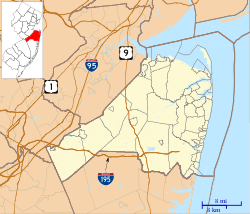
Southard is an unincorporated community located within Howell Township in Monmouth County, New Jersey, United States, centered around U.S. Route 9.[2][3] It was once known as Bethel.[4][5]
Southard, New Jersey | |
|---|---|
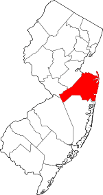
 Southard, New Jersey Location of Southard in Monmouth County Inset: Location of county within the state of New Jersey  Southard, New Jersey Southard, New Jersey (New Jersey)  Southard, New Jersey Southard, New Jersey (the United States) | |
| Coordinates: 40°08′18″N 74°13′30″W | |
| Country | |
| State | |
| County | Monmouth |
| Township | Howell |
| Elevation | 118 ft (36 m) |
| Time zone | UTC-5 (Eastern (EST)) |
| • Summer (DST) | UTC-4 (EDT) |
| GNIS feature ID | 880764[1] |
References
- "Southard". Geographic Names Information System. United States Geological Survey.
- "NJDOT Graphic Information System Maps Middlesex" (PDF). New Jersey Department of Transportation. Retrieved March 29, 2020.
- Locality Search, State of New Jersey. Accessed March 4, 2015.
- Gannett, Henry (January 28, 1895). "A Geographic Dictionary of New Jersey". U.S. Government Printing Office – via Google Books.
- "History of Howell Township". Howell Township. Retrieved April 3, 2020.
The area was later called Turkey...before becoming known as Adelphia. In addition to Adelphia, Howell has a number of other early settlement areas that later became suburban neighborhoods: Bethel (Southard), Jerseyville (originally called Green Grove), Ramtown, Squankum, Freewood Acres, and Ardena. Bethel, an area in the southwest part of Howell Township, was settled in 1865 when a lot was donated by Israel Reynolds to build a Methodist Church that was completed in 1866. A school house opened in 1870, followed by a store in 1872. A post office opened in 1882 and reflected the area’s name change from Bethel to Southard.
This article is issued from Wikipedia. The text is licensed under Creative Commons - Attribution - Sharealike. Additional terms may apply for the media files.
