Sigoyer, Hautes-Alpes
Sigoyer is a commune in the Hautes-Alpes department in southeastern France.
Sigoyer | |
|---|---|
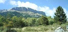 A view of the south side of the Corniche de Céûse, seen from Sigoyer | |
 Coat of arms | |
Location of Sigoyer 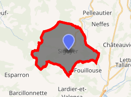
| |
 Sigoyer  Sigoyer | |
| Coordinates: 44°28′43″N 5°58′36″E | |
| Country | France |
| Region | Provence-Alpes-Côte d'Azur |
| Department | Hautes-Alpes |
| Arrondissement | Gap |
| Canton | Tallard |
| Intercommunality | Tallard-Barcillonnette |
| Government | |
| • Mayor (2008–2014) | Maurice Ricard |
| Area 1 | 24.38 km2 (9.41 sq mi) |
| Population (2017-01-01)[1] | 665 |
| • Density | 27/km2 (71/sq mi) |
| Time zone | UTC+01:00 (CET) |
| • Summer (DST) | UTC+02:00 (CEST) |
| INSEE/Postal code | 05168 /05130 |
| Elevation | 639–2,000 m (2,096–6,562 ft) (avg. 1,060 m or 3,480 ft) |
| 1 French Land Register data, which excludes lakes, ponds, glaciers > 1 km2 (0.386 sq mi or 247 acres) and river estuaries. | |
Population
| Year | Pop. | ±% |
|---|---|---|
| 1962 | 304 | — |
| 1968 | 304 | +0.0% |
| 1975 | 245 | −19.4% |
| 1982 | 306 | +24.9% |
| 1990 | 418 | +36.6% |
| 1999 | 583 | +39.5% |
| 2008 | 650 | +11.5% |
gollark: How come you can't accept that mysterious hatchling?
gollark: I... why?
gollark: Someone just put up a trade offer for a spitfire on my copper genderswap trade.
gollark: I only have CB ones growing up now.
gollark: Gaaaaah. I haven't gotten a single female copper out of 5.
References
- "Populations légales 2017". INSEE. Retrieved 6 January 2020.
| Wikimedia Commons has media related to Sigoyer, Hautes-Alpes. |
This article is issued from Wikipedia. The text is licensed under Creative Commons - Attribution - Sharealike. Additional terms may apply for the media files.