Aiguilles
Aiguilles is a commune of the Hautes-Alpes department in southeastern France.
Aiguilles | |
|---|---|
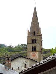
 The bell tower of the church of Saint-Jean-Baptiste | |
 Coat of arms | |
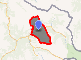
Location of Aiguilles 
| |
 Aiguilles  Aiguilles | |
| Coordinates: 44°46′57″N 6°52′11″E | |
| Country | France |
| Region | Provence-Alpes-Côte d'Azur |
| Department | Hautes-Alpes |
| Arrondissement | Briançon |
| Canton | Guillestre |
| Intercommunality | Guillestrois et Queyras |
| Government | |
| • Mayor (2014-2020) | Serge Laurens |
| Area 1 | 40.16 km2 (15.51 sq mi) |
| Population (2017-01-01)[1] | 429 |
| • Density | 11/km2 (28/sq mi) |
| Time zone | UTC+01:00 (CET) |
| • Summer (DST) | UTC+02:00 (CEST) |
| INSEE/Postal code | 05003 /05470 |
| Elevation | 1,400–3,078 m (4,593–10,098 ft) (avg. 1,471 m or 4,826 ft) |
| 1 French Land Register data, which excludes lakes, ponds, glaciers > 1 km2 (0.386 sq mi or 247 acres) and river estuaries. | |
Geography
The village lies in the middle of the commune, on the right bank of the Guil, which flows southwest through the commune.
Population
| Year | Pop. | ±% |
|---|---|---|
| 2005 | 412 | — |
| 2006 | 412 | +0.0% |
| 2007 | 412 | +0.0% |
| 2008 | 419 | +1.7% |
| 2009 | 426 | +1.7% |
| 2010 | 433 | +1.6% |
| 2011 | 394 | −9.0% |
| 2012 | 449 | +14.0% |
| 2013 | 444 | −1.1% |
| 2014 | 434 | −2.3% |
| 2015 | 425 | −2.1% |
| 2016 | 428 | +0.7% |
Politics
Presidential Elections 2nd Round [2]
| Election | Winning Candidate | Party | % | |
|---|---|---|---|---|
| 2017 | Emmanuel Macron | EM | 70.00 | |
| 2012 | Nicolas Sarkozy | UMP | 53.78 | |
| 2007 | Ségolène Royal | PS | 51.39 | |
| 2002 | Jacques Chirac | RPR | 85.02 | |
gollark: Expanding on what I previously said, you can already pay for a commercial suborbital flight these days, and space travel is cheapening, so maybe by 2030 you'll be able to travel between continents by rocket in an hour or so by commercial suborbital rocket for... a million dollars or so.People will inevitably complain about this, too.
gollark: The nuclear fuel heats the propellant which gives it exhaust velocity.
gollark: Yes they do. Not that they're actually used because nuclear.
gollark: Nuclear rockets are.
gollark: Yes, but... airships. Being in the air introduces extra challenges.
References
- "Populations légales 2017". INSEE. Retrieved 6 January 2020.
- http://www.lemonde.fr/data/france/presidentielle-2017/
| Wikimedia Commons has media related to Aiguilles. |
This article is issued from Wikipedia. The text is licensed under Creative Commons - Attribution - Sharealike. Additional terms may apply for the media files.