Chabottes
Chabottes is a commune in the Hautes-Alpes department in southeastern France.
Chabottes | |
|---|---|
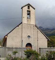 The chapel in Chabottes | |
 Coat of arms | |
Location of Chabottes 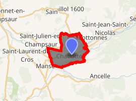
| |
 Chabottes  Chabottes | |
| Coordinates: 44°38′38″N 6°10′18″E | |
| Country | France |
| Region | Provence-Alpes-Côte d'Azur |
| Department | Hautes-Alpes |
| Arrondissement | Gap |
| Canton | Saint-Bonnet-en-Champsaur |
| Intercommunality | Champsaur |
| Government | |
| • Mayor (2014–2020) | Roland Aymeric |
| Area 1 | 9.96 km2 (3.85 sq mi) |
| Population (2017-01-01)[1] | 825 |
| • Density | 83/km2 (210/sq mi) |
| Time zone | UTC+01:00 (CET) |
| • Summer (DST) | UTC+02:00 (CEST) |
| INSEE/Postal code | 05029 /05260 |
| Elevation | 1,028–1,347 m (3,373–4,419 ft) (avg. 1,080 m or 3,540 ft) |
| 1 French Land Register data, which excludes lakes, ponds, glaciers > 1 km2 (0.386 sq mi or 247 acres) and river estuaries. | |
Population
| Year | Pop. | ±% |
|---|---|---|
| 1962 | 469 | — |
| 1968 | 430 | −8.3% |
| 1975 | 461 | +7.2% |
| 1982 | 453 | −1.7% |
| 1990 | 518 | +14.3% |
| 1999 | 610 | +17.8% |
| 2008 | 750 | +23.0% |
gollark: Probably not.
gollark: I wonder if the autobias affected it at all.
gollark: Interesting. This has been added to your psychological profile.
gollark: What if we're all in a simulation testing slightly different versions of Discord?
gollark: What if exposing the experiment screen is itself an experiment?
References
- "Populations légales 2017". INSEE. Retrieved 6 January 2020.
| Wikimedia Commons has media related to Chabottes. |
This article is issued from Wikipedia. The text is licensed under Creative Commons - Attribution - Sharealike. Additional terms may apply for the media files.